My Trail Story by Craig Fowler
Planning an adventure? Check out our popular trail guides! 4.8 stars (17K+ ratings)
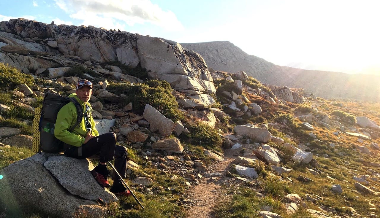
Photo by Craig Fowler
My Trail Story featuring Craig Fowler
Craig Fowler shares his story of how he became a thru-hiker and bikepacker, and how he turned his passions into a full-time project.
Natalie McMillan My Trail Story 02/13/2019
Natalie McMillan
My Trail Story
02/13/2019
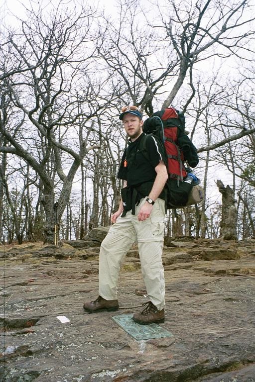
Photo by Craig Fowler
I first thru-hiked the Appalachian Trail in 2001. My journey started a few weeks shy of my 13th birthday, with a day hike up Mt. Katahdin in 1985 while on vacation in Baxter State Park. This is where the seed was planted to thru-hike the entire AT. Sixteen years later, in 2001, I took my first steps northbound on the AT. I finished 153 days later, a changed person.
I was always the one who wanted to see what was around the next corner whenever I went on walks with my late Grandfather. I was a curious child for sure. I think this is why when I got my first bicycle I fell in love. My bike allowed me to go further, see more, and simply gave me more freedom.
I was one of those people who get “hooked” as others like to say. I knew from the time I finished the AT that I would go on to do the Pacific Crest Trail (PCT). I even moved to Seattle to be closer to the PCT and then to Colorado for the Continental Divide Trail (CDT). The AT had sunk it’s claws in me. Being the geek that I am, I like to compare the AT to the Terragin Crystals in the Marvel Universe. If you have the mutant gene in you, the Terragin awakens it, giving you your powers.
I like to think exploring, wanderlust, the need to see more, or what’s around every corner was always in me, and the AT truly awoke it. It changed me and made me who I am now. I could never go back to a “normal” life. The AT gave me a small taste of a larger world, a world I wanted to explore.
By 2003 I hit the Long Trail as an Ultralighter. Next was the PCT in 2007 (which included riding my bicycle from Seattle, WA to the southern terminus of the PCT and then riding home from Manning Park to Seattle), and finally I completed my Triple Crown in 2015 by thru-hiking the CDT. 30 years later that seed had fully matured.
After completing a 30 year dream I was left pretty depressed throughout 2016. In the Fall of that year I had had enough and sat myself down and came up with a new goal. I had seen the movie “The Martian” starring Matt Damon, where he’s trapped on Mars alone. During his time there he realizes he’s the only person to ever be alone on a planet. This struck a cord deep inside me. I wondered what I could do to be the only person to have done something.
After some research I determined no one had done both the Thru-hiking and Bikepacking Triple Crowns before. Being a cyclist for 27 years, at this point it was a natural fit. I had already tried so many cycling disciplines from cross country to downhill to cyclocross to endurance racing. Bikepacking had been on my short list for a while.
Bikepacking after all is basically hiking but with your bicycle. It was then I decided to complete the Bikepacking Triple Crown, which includes the Arizona Trail Race, from the Mexico border to the Utah border, 757 miles; Tour Divide, from Banff, AB to Antelope Wells, NM, 2660.8 miles; and the Colorado Trail Race, from Durango to Denver, 538.9 miles, in the same year.
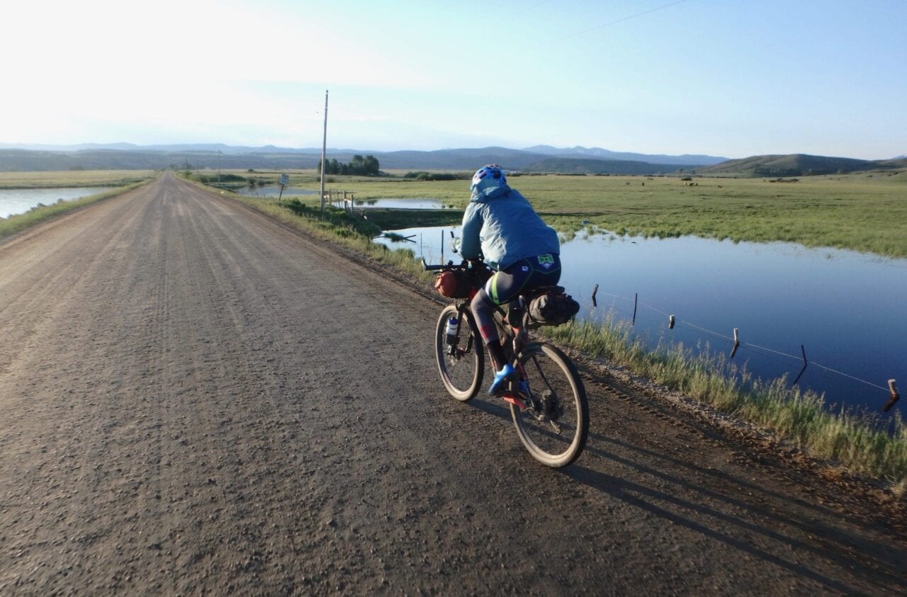
Photo by Craig Fowler
From June to October of 2017 I completed all three bikepacking races and became One of Seven Billion. This is where the name of my project came from, the One of Seven Project. When I started it, the goal was a personal one. But I always knew I wanted to grow the Project into something bigger, I just didn’t know what when I started it.
For years I had been enjoying great trails across the country, both on my bike and on foot. I always wanted to give back. The little bit of trail work I had done wasn’t enough. I wanted the Project to help others experience what I had.
As the Project unfolded many things became apparent to me. One that really stood out was we’re all born One of Seven Billion with our own DNA, but not all of us choose to celebrate that uniqueness. From this realization and others, I formed the Project’s Core Values and found the new focus of the Project.
Encourage others to truly know themselves and their passions.
Assist others in celebrating their uniqueness by following those passions that make them unique.
Humanize adventure.
Help others be the best version of themselves.
A big part of of the Project’s focus is about breaking down both mental and physical barriers keeping us all from following our passions. To help break down those barriers I created four first of a kind Bikepacking Guides:
Bikepacking is fairly new, and as a result there wasn’t the kind of guides the hiking world has in place. This was a barrier I could help remove, so I built guides with what I learned during my bikepacking triple crown. If I’m being honest I was inspired by the gang at Guthook. My goal was to make it easier for others to get out on the trail and experience the outdoors.
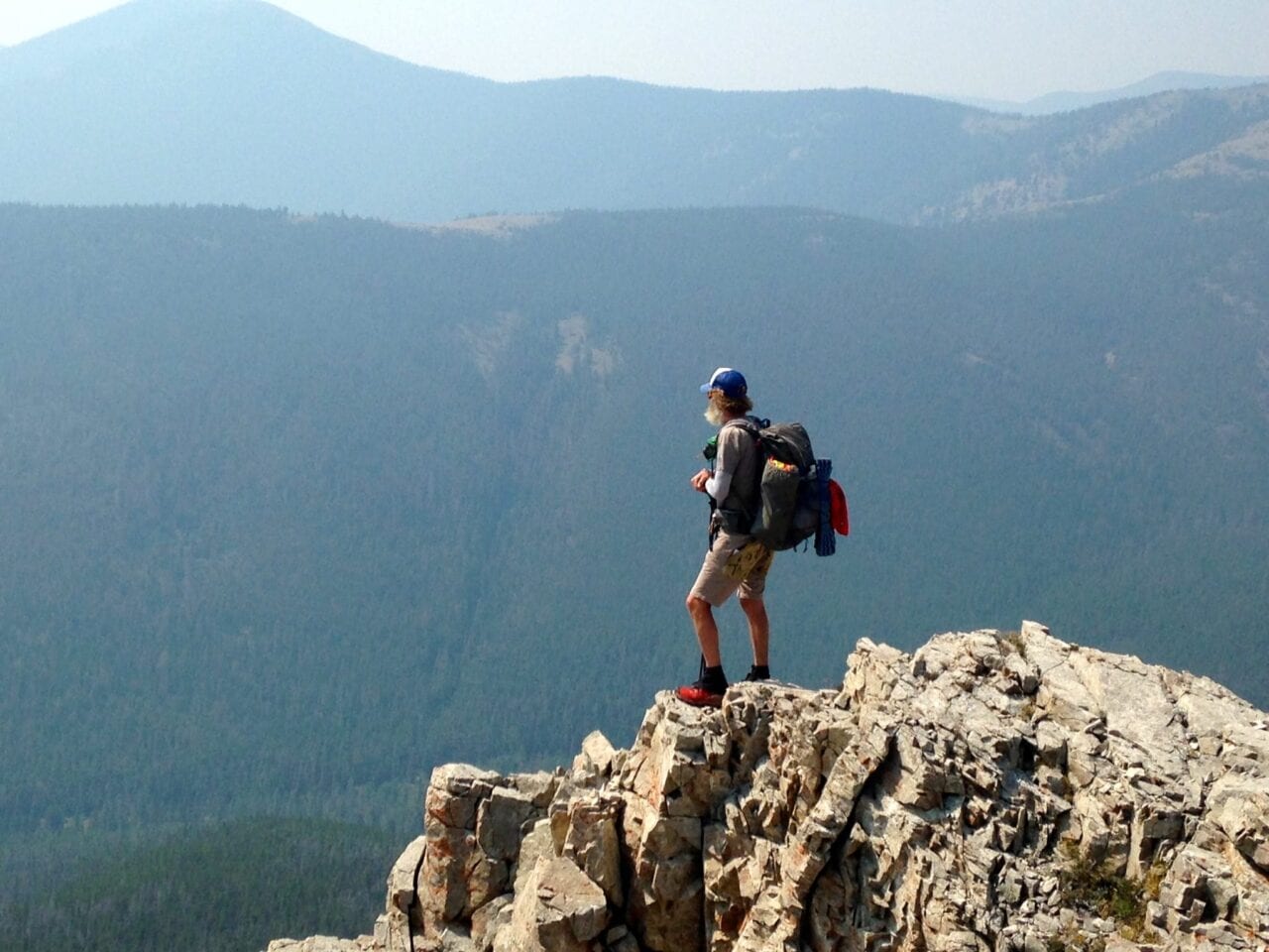
Photo by Dahn Pratt
The information out there is spread across the web, and finding it is overly time consuming. I saw no point in keeping the knowledge I gained over all those years to myself and sought to combine it with what is online. By combing it all into one location, the barrier of finding it would hopefully be removed, resulting in more people getting outside or following their passions.
In 2019 I plan to produce two more Bikepacking and six Hiking Guides to add to the four mentioned above.
- Coconino 250
- The Lake Trail (Cycling loop around Lake Tahoe)
- Long Trail
- John Muir Trail or Colorado Trail (hiking)
- Appalachian Trail
- Pacific Crest Trail
- Continental Divide Trail
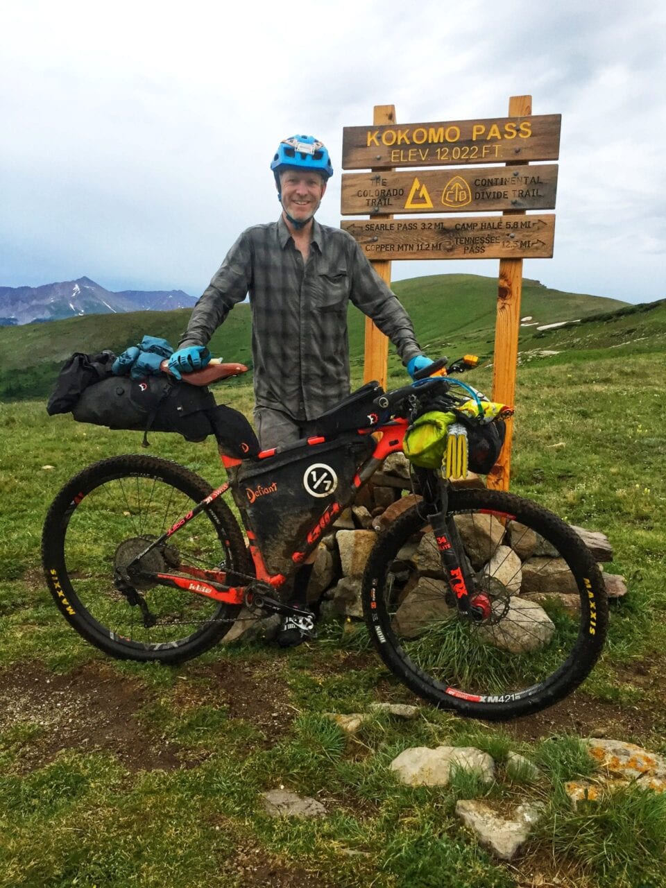
Photo by Craig Fowler
Accompanying these guides I have produced Bikepacking and Hiking Resources to further help others follow their passions.These Resources are blog posts/pages, where I share what I have learned, in hopes of making the process of following one’s passions easier. Going into the hiking forums online, I saw people asking the same questions I had when I started. It’s the Project’s goal to answer as many of those as it can.
Overall my journey is probably not that different from others but with it’s own twist. Like me, it’s unique. I might have taken my exploring further than some or less. In the end I’m just another thru-hiker who realized that the life I had before the trail wasn’t the one for me. I’ve forgotten that feeling many times but finally I’m listening.
For more inspiration checkout the Project’s Passion Profiles — a collection of short interviews meant to inspire, motivate, and to help break down barriers that might be holding you back from following your own passions.
To learn more about the One of Seven Project, its mission, and what it has to offer you, please visit the website or reach out to me at info@oneosfsevenproject.com.
Want to keep up with all that’s going on at Atlas Guides? Sign up for our newsletter!
Read more!
Check out some related blog posts!
Get our trail guide for this area!
Appalachian Trail
The Appalachian Trail is one of the oldest National Scenic Trails in the US. Its path takes you from Springer Mountain in Georgia to Mt. Katahdin in Maine.
2200 mi (3540 km) $59.99 full guide
Pennsylvania, Appalachian Trail
Photo by Zoë Symon
Pennsylvania, Appalachian Trail
Photo by Zoë Symon
Appalachian Trail
The Appalachian Trail is one of the oldest National Scenic Trails in the US. Its path takes you from Springer Mountain in Georgia to Mt. Katahdin in Maine.
2200 mi (3540 km)
$59.99 full guide
Get our trail guide for this area!
About the Author

Natalie McMillan
Natalie grew up hiking in Arizona where she fell in love with the outdoors. Her favorite hikes are to Havasu Falls in the Grand Canyon and Angel’s Landing in Zion National Park, UT. She loves taking pictures of people, places, and nature, which might explain why she has almost 47,000 photos currently residing on her phone. She takes care of all things related to social media and marketing and recently moved to Denver, CO from Flagstaff, AZ. You may find her frolicking around the trails and mountains of Colorado, or exploring the new city she gets to call home.
My Trail Story by Grizzly
Planning an adventure? Check out our popular trail guides! 4.8 stars (17K+ ratings)
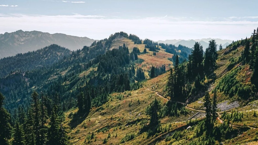
Photo by Michael Ivey
My Trail Story featuring Grizzly
Our "My Trail Story" series features thru-hikers of all ages and backgrounds sharing their personal, real-life experiences from the trail. Michael Ivey, also known as Grizzly, kicks off this series by answering some questions about his thru-hiking experience.
Natalie McMillan My Trail Story 01/31/2019
Natalie McMillan
My Trail Story
01/31/2019
What is your trail name?
Grizzly
What trail(s) did you hike?
I have hiked the John Muir Trail ’14, Pacific Crest Trail ’15, Colorado Trail ’16, Superior Hiking Trail ’18, large sections of the CDT ’16, and will be hiking the Pacific Crest Trail and Colorado Trail again in 2019
How old are you?
I am 36 years old.
What was one thing you wish you knew before you started hiking?
I wish I would have initially bought ultra light gear rather then being on a budget. In the long run I’ve spent much more money because of it.
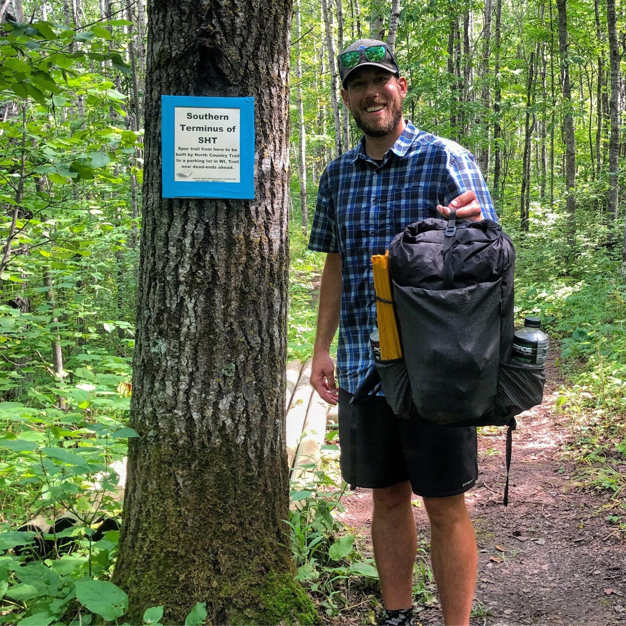
Photo by Michael Ivey
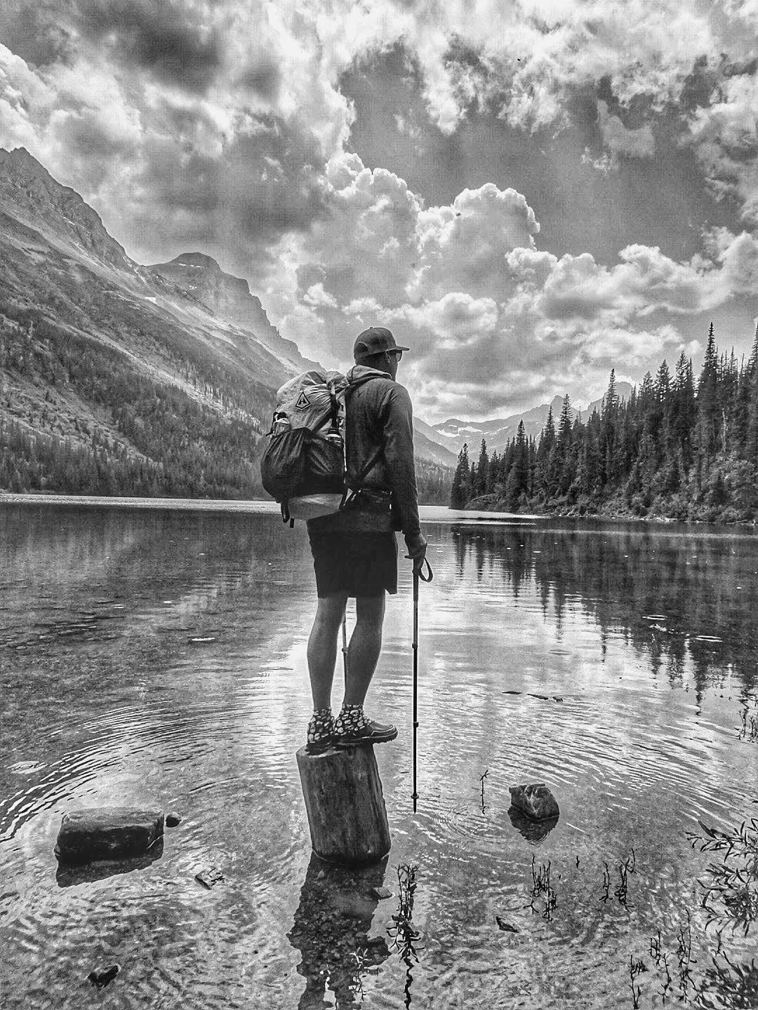
Photo by Michael Ivey
What is your favorite food on the trail?
I typically cold soak my meals so I eat a lot of ramen. That being said, peanut butter is always a favorite as well as cheese and summer sausage.
What advice would you give to someone who has never done a thru-hike before?
I’d say give it a shot if you love backpacking and the outdoors. A lot of people think it’s something unachievable and are intimidated by it before they have even tried one.
What does thru-hiking mean to you?
It means relaxing and re-centering myself. I feel more like myself on a long trail then anywhere else.
Would you do another thru-hike? If yes, which trail is next?
Absolutely, and I’ll be doing the PCT and CT again this year. It will be my second thru-hike of each. I also section hiked 200 miles of the CT in 2018.
What was the easiest/hardest part about your thru-hike?
The easiest part was enjoying my surroundings and the beauty that surrounded me. It wasn’t hard to stay motivated. The hardest part for me is slowing down at times. I have a tendency to just put my head down and do miles rather then slowing down to enjoy my surroundings.
What do you wish you had done differently?
I wish I would have thru-hiked the CDT in 2016 rather then just doing a long section hike. I kick myself all the time for not finishing the trail that year.
What do you miss the most?
The simplicity of thru hiking. It’s just wake up, walk, eat, look for water, and sleep.
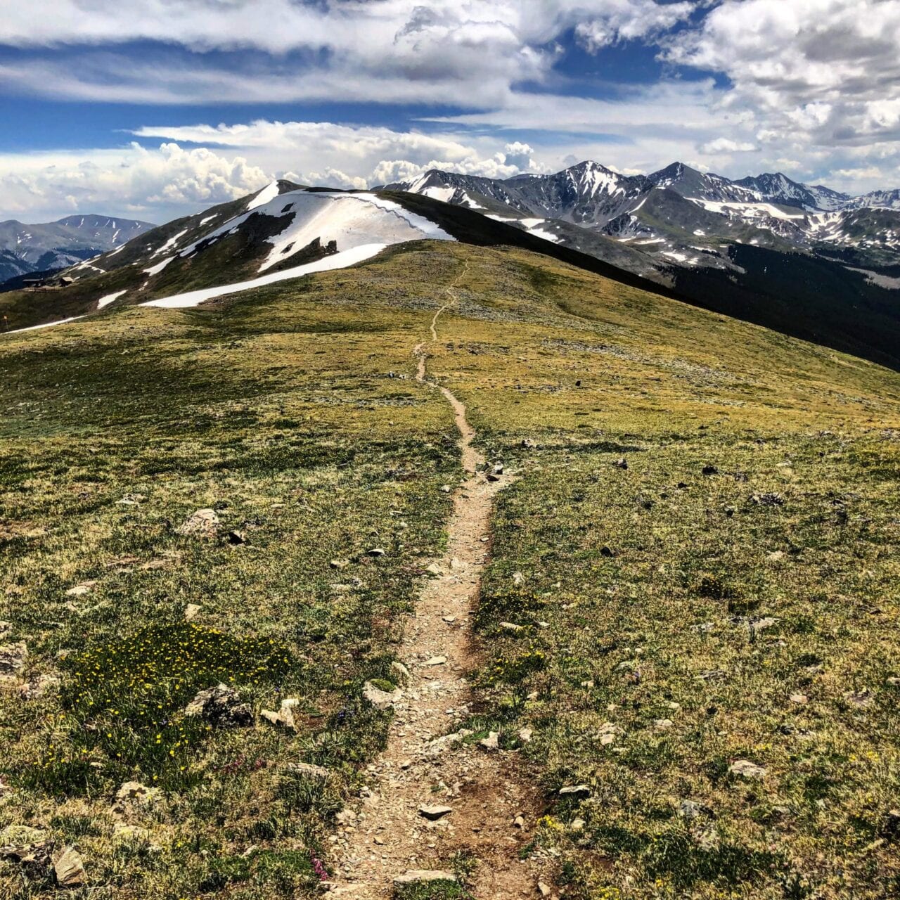
Photo by Michael Ivey
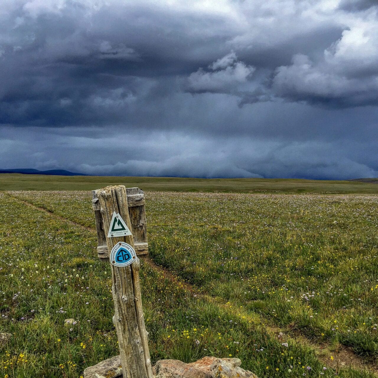
Photo by Michael Ivey
What was your favorite feature in our app?
Elevation profiles are something I love about the app. I planned my days around climbs especially in the Sierras and Colorado Rockies.
What was the one thing you had to have with you while you hiked?
I’m pretty attached to my Patagonia R1 hoodie.
Why did you decide to go on a thru-hike in the first place?
Honestly, to see more of the country and to get away from working so much.
Did you hike solo or with other people?
I hiked with other people. Most long trails are fairly crowded at this point, making it tough to ever really be alone.
What part of the trail was your most/least favorite?
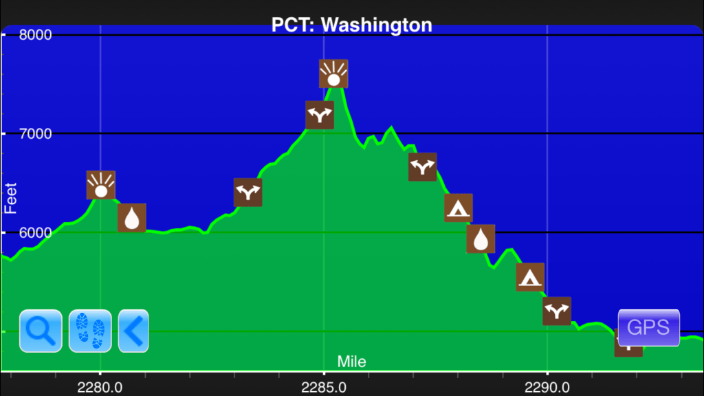
Washington on the PCT and Glacier on the CDT were my favorites. New Mexico on the CDT is pretty low on my list of places to hike through again.
How many pairs of shoes did you go through?
I average about 500 miles per pair of shoes. I exclusively hike in Altra shoes and love them.
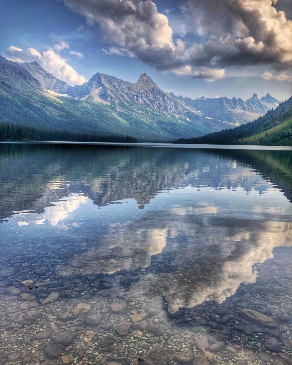
Photo by Michael Ivey
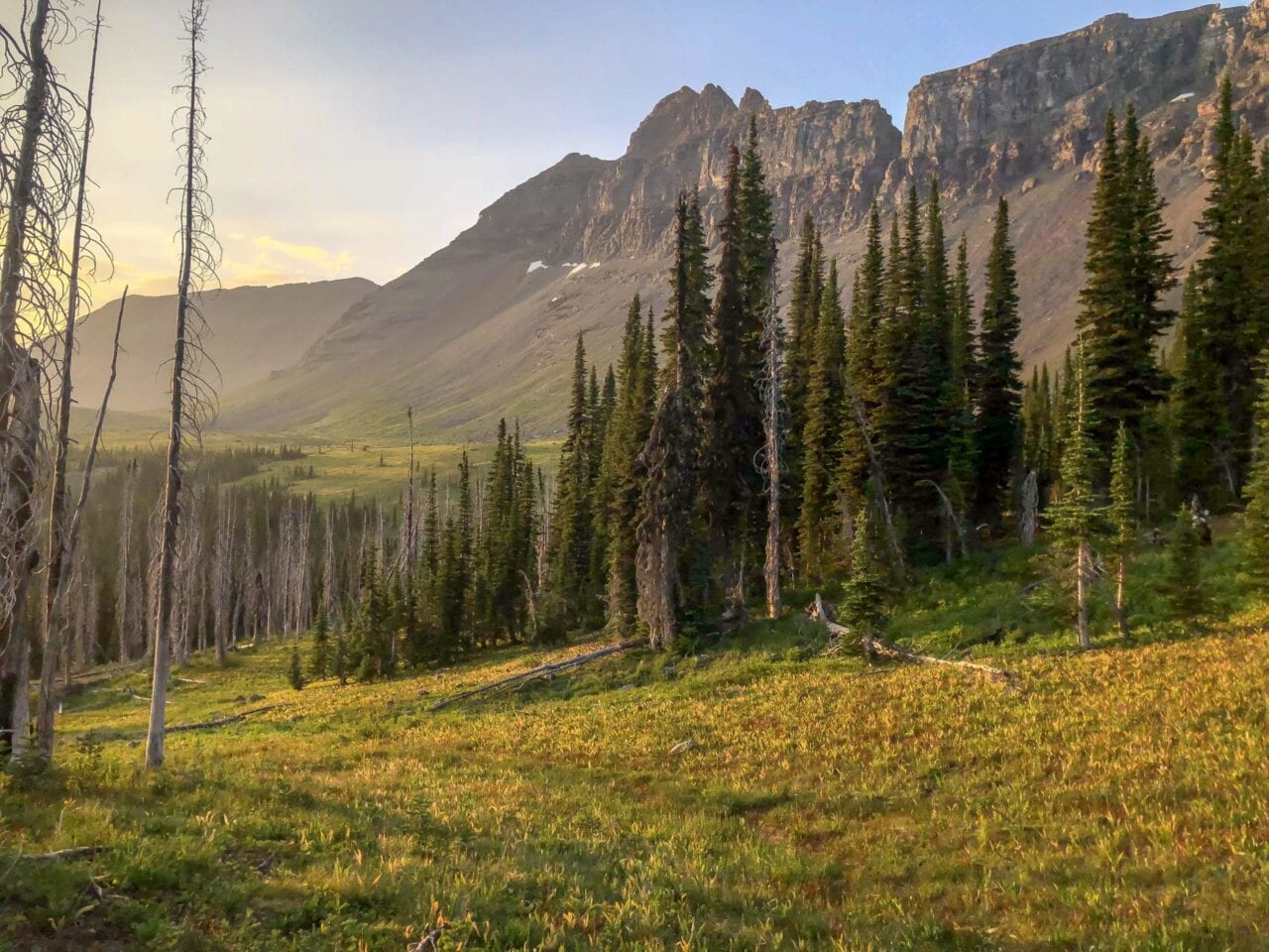
Photo by Michael Ivey
Was there a highlight of your hike?
Goat Rocks and Glacier Peak Wilderness are always a highlight.
What was the scariest part of your hike?
Scaring a grizzly bear out of camp on my first night of the CDT was a thrill.
Did you ever reach a point where you wanted to quit? How did you stay motivated to finish?
Yeah I was pretty down while hiking the CDT. I had pretty bad weather early on and a very bad sinus infection. Ultimately I got off the CDT and thru-hiked the CT before getting back on the CDT for as long as the weather would hold out.
Want to keep up with all that’s going on at Atlas Guides? Sign up for our newsletter!
Read more!
Check out some related blog posts!
Get our trail guide for this area!
Pacific Crest Trail
The Pacific Crest Trail is an epic journey of three states and over 2600 miles. Its path travels from the US border with Mexico to the northern border with Canada.
2650 mi (4260 km) $29.99 full guide
Washington, Pacific Crest Trail
Photo by Justin Helmkamp
Washington, Pacific Crest Trail
Photo by Justin Helmkamp
Pacific Crest Trail
The Pacific Crest Trail is an epic journey of three states and over 2600 miles. Its path travels from the US border with Mexico to the northern border with Canada.
2650 mi (4260 km)
$29.99 full guide
Get our trail guide for this area!
About the Author
Natalie McMillan
Natalie grew up hiking in Arizona where she fell in love with the outdoors. Her favorite hikes are to Havasu Falls in the Grand Canyon and Angel’s Landing in Zion National Park, UT. She loves taking pictures of people, places, and nature, which might explain why she has almost 47,000 photos currently residing on her phone. She takes care of all things related to social media and marketing and recently moved to Denver, CO from Flagstaff, AZ. You may find her frolicking around the trails and mountains of Colorado, or exploring the new city she gets to call home.
What Are the Steepest Climbs on the AT, PCT, and CDT?
Planning an adventure? Check out our popular trail guides! 4.8 stars (17K+ ratings)
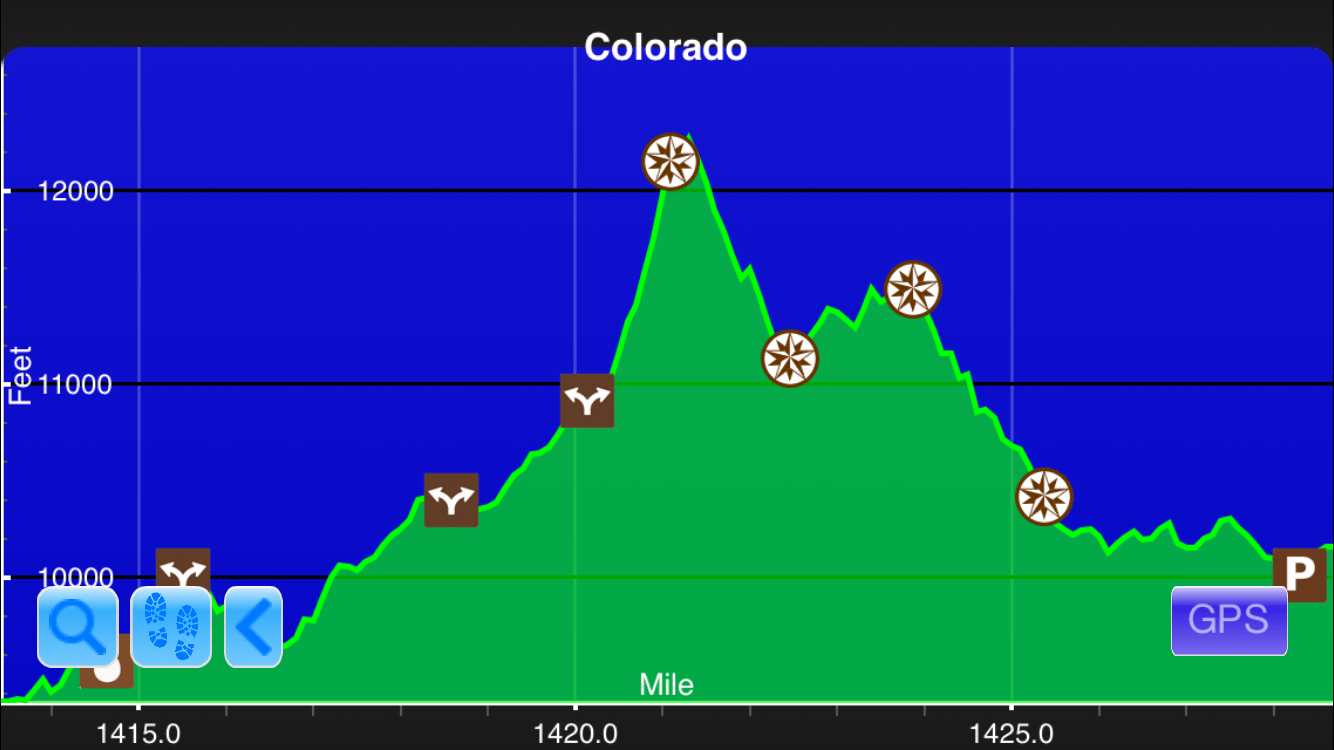
CDT #1: The climb to Parkview Mountain in CO (1400′ in 1.1 mi).
Screenshot from the Guthook Guides app
What Are the Steepest Climbs on the AT, PCT, and CDT?
I used my elevation profile data plus my programming knowledge to analyze the climbs on the AT, PCT, and CDT to come up with a good estimate of the steepest parts of the Triple Crown trails.
Ryan Linn Tech on the Trail 01/05/2015
Ryan Linn
Tech on the Trail
01/05/2015
Last year, I found a forum thread on Whiteblaze with a debate about “what is the steepest climb on the Appalachian Trail?” I thought about it for a while, then decided I might use my elevation profile data for the AT, plus my programming knowledge, to analyze the climbs of the AT to come up with a good estimate of what really is the steepest part of the Appalachian Trail.
My method for measuring the steepest climbs requires a little bit of explanation: the program broke the trail down into 0.5 mile segments (initially 1.0 miles, but I decided 0.5 would give better results), including overlapping segments (0.0 to 0.5, 0.1 to 0.6, 0.2 to 0.7, etc.). It first sorted through all segments to find the largest elevation change in any segment, then discarded any overlapping segments (if 2.0 to 2.5 was steeper than 2.2 to 2.7, the latter was discarded). Shortening the length of a measured segment might provide a more accurate measure of the absolutely steepest climbs, but I had to make a cut-off somewhere, since if we looked only at 0.1 mile segments we might just find flukes in the elevation data, like a single ladder that climbs over a boulder.
More recently, I applied the same measure to the PCT as a fun way to compare the two trails. Obviously, the steepness of the two trails doesn’t entirely reflect the challenges, but it’s fun to look at. Also, since my apps have the same vertical exaggeration for all elevation profiles, we can look at the profile of the AT and PCT and really see how they compare.
Here are the results:
Edit: Bobcat requested I run the numbers for the CDT as well, so I’ve added them as of 1/6/2015. The Overall gain/loss is calculated only with the CDT Proper, while the steepest climbs include the various alternate routes as mapped by Bear Creek Survey.
- Overall elevation gain/loss on Appalachian Trail: 917,760′ over 2185.3 mi (avg: 420’/mi)
- Overall elevation gain/loss on Pacific Crest Trail: 824,370′ over 2668.8 mi (avg: 309’/mi).
- Overall elevation gain/loss on Continental Divide Trail: 917,470′ over 3029.3 mi (avg: 303’/mi).
Fifth Steepest Climbs on the Triple Crown:
PCT #5: Mono Creek toward Silver Pass (a section of 550′ in 0.6 mi).
Screenshot from the Guthook Guides app
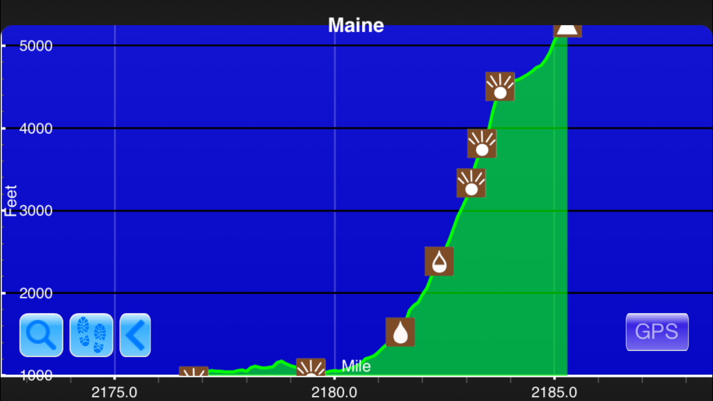
AT #5: O Joy Brook to the Tableland on Katahdin (2100′ in 1.4 mi, with a 860′ climb in 0.5 mi).
Screenshot from the Guthook Guides app
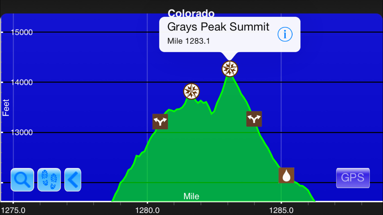
CDT #5: The climb to Grays Peak Summit in CO (about 800′ in 0.8 mi).
Screenshot from the Guthook Guides app
Fourth Steepest Climbs on the Triple Crown:
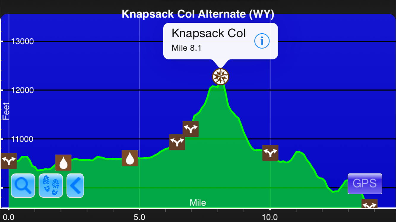
CDT #4: The descent from Knapsack Col in the Knapsack Col alternate (1400′ in 1.3 mi).
Screenshot from the Guthook Guides app
Third Steepest Climbs on the Triple Crown:
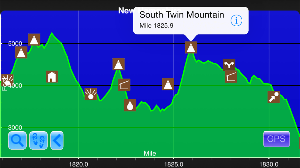
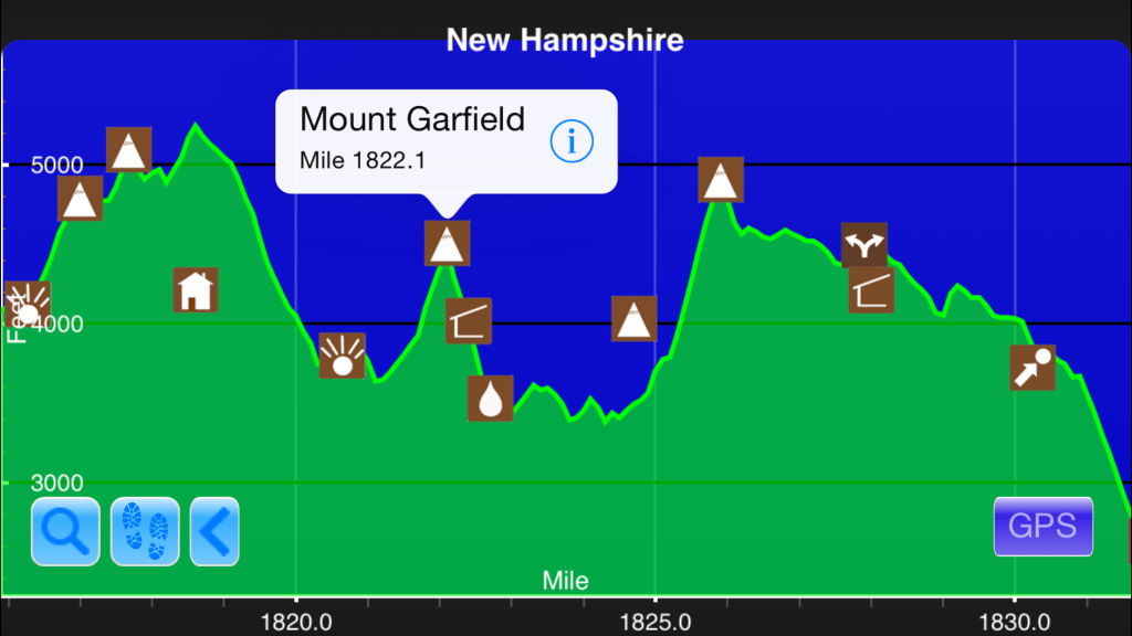
AT #3: Galehead Hut to South Twin (1130′ in 0.8 mi, with about 900′ in 0.5 mi).
Screenshot from the Guthook Guides app
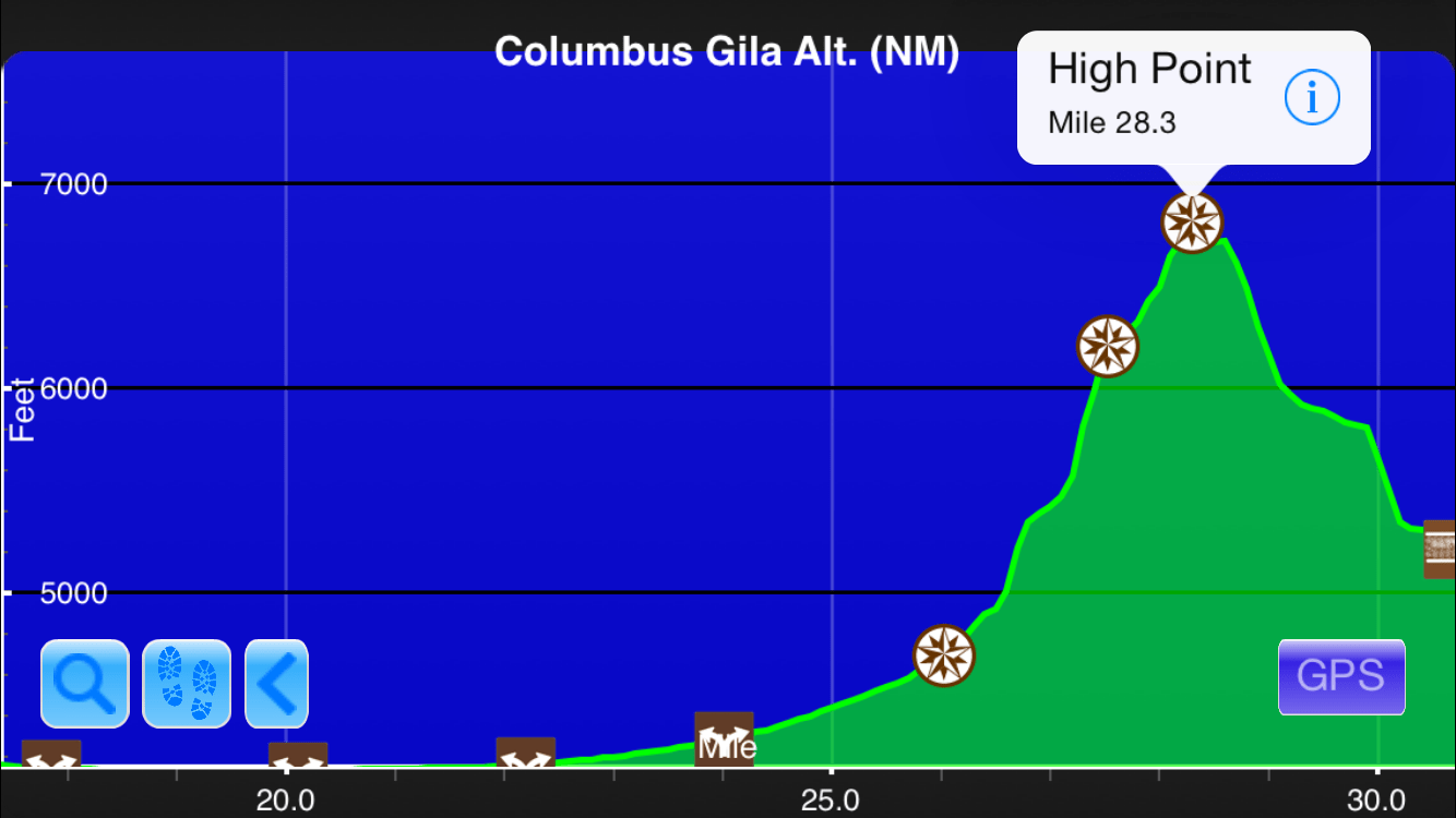
CDT #3: The climb to South Peak on Columbus Gila alternate (1900′ in 1.8 mi).
Screenshot from the Guthook Guides app
Second Steepest Climbs on the Triple Crown:

AT #2: Beaver Brook Shelter to Kinsman Notch (2200′ in 1.7 mi, with one 930′ climb in 0.5 mi).
Screenshot from the Guthook Guides app
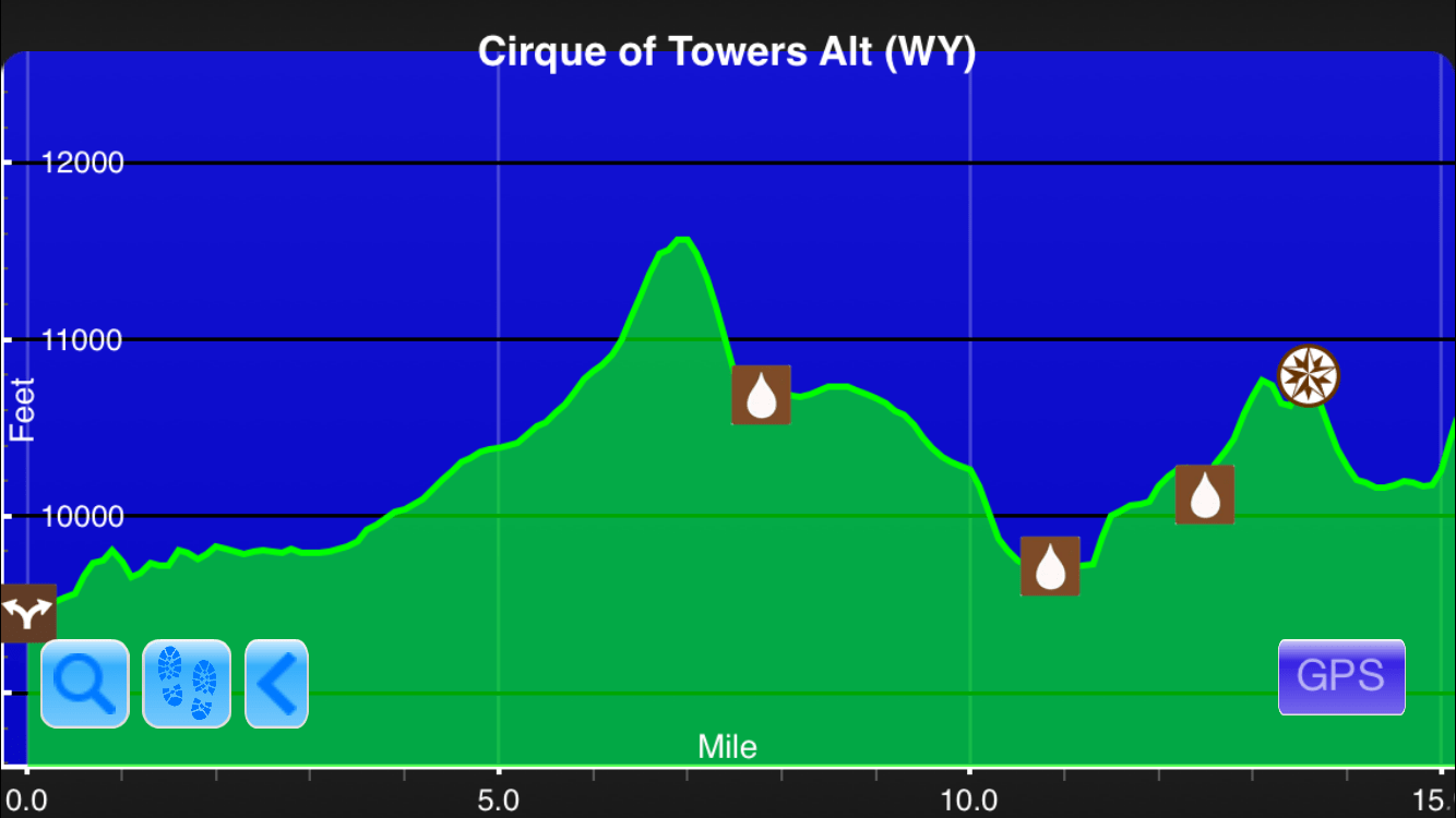
CDT #2: The descent from Temple Pass to Temple Lake on Cirque of the Towers alternate (900′ in 0.6 mi).
Screenshot from the Guthook Guides app
Steepest Climbs on the Triple Crown:
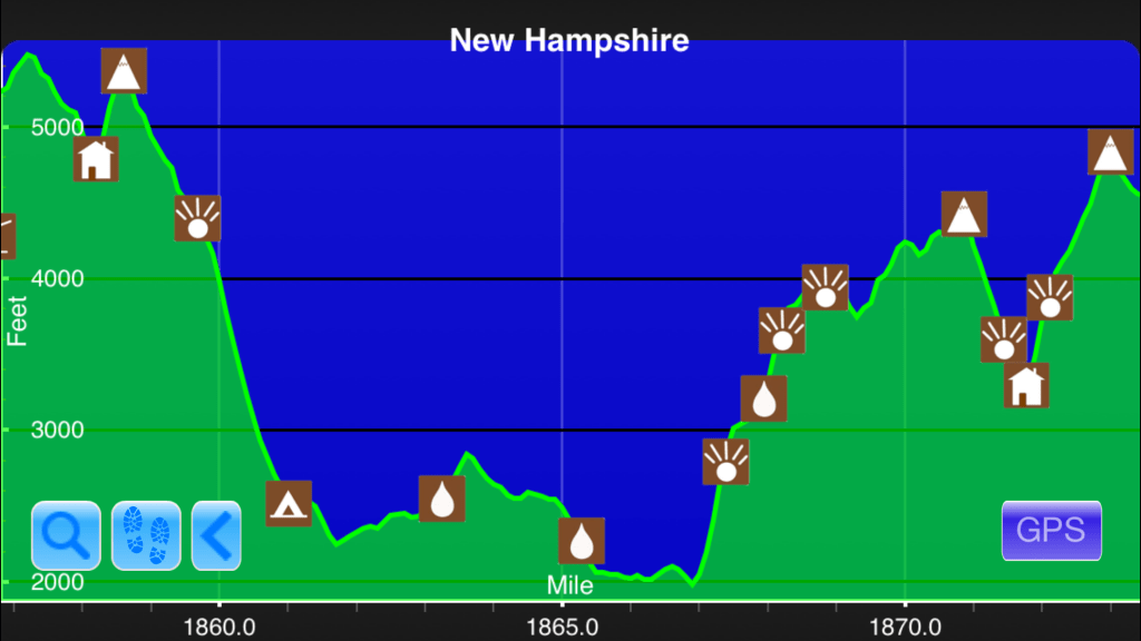
AT #1: Pinkham Notch to Wildcat E (2000′ in 1.5 miles, with one 1000′ climb in 0.5 mile).
Screenshot from the Guthook Guides app
CDT #1: The climb to Parkview Mountain in CO (1400′ in 1.1 mi).
Screenshot from the Guthook Guides app
Want to keep up with all that’s going on at Atlas Guides? Sign up for our newsletter!
Read more!
Check out some related blog posts!
Download our popular hiking and biking guides!

Trail guides that get you to places you’ve dreamed of.
As the makers of Guthook Guides, Bikepacking Guides, and Cyclewayz, we help you navigate the most popular trails around the world on your smartphone. Our hiking guides and biking guides work completely offline. Let Guthook guide your next adventure!
Showers Lake Vista, Tahoe Rim Trail
Photo courtesy of the Tahoe Rim Trail Association

Showers Lake Vista, Tahoe Rim Trail
Photo courtesy of the Tahoe Rim Trail Association
Trail guides that get you to places you’ve dreamed of.
As the makers of Guthook Guides, Bikepacking Guides, and Cyclewayz, we help you navigate the most popular trails around the world on your smartphone. Our hiking guides and biking guides work completely offline. Let Guthook guide your next adventure!
Download our popular hiking and biking guides!
About the Author

Ryan Linn
Ryan is also known as “Guthook”, which is where our apps get their name. Already an avid hiker, he hiked the Appalachian Trail, New England Trail, and Pacific Crest Trail before joining forces with Paul to create the Guthook Guides apps. Ryan handles iOS development for our apps from his office in Maine, and usually runs away to the forests and mountains throughout New England. He also volunteers with the Maine Appalachian Trail Club and the Natural Resources Council of Maine. Baxter State Park in Maine is his happy place.