Explore New Alternate Trails in the Gila Wilderness
Planning an adventure? Check out our popular trail guides! 4.8 stars (17K+ ratings)
Explore New Alternate Trails in the Gila Wilderness
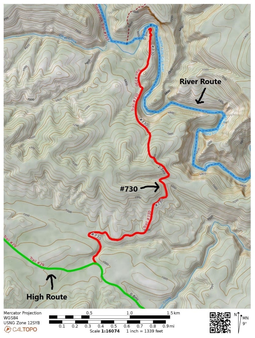
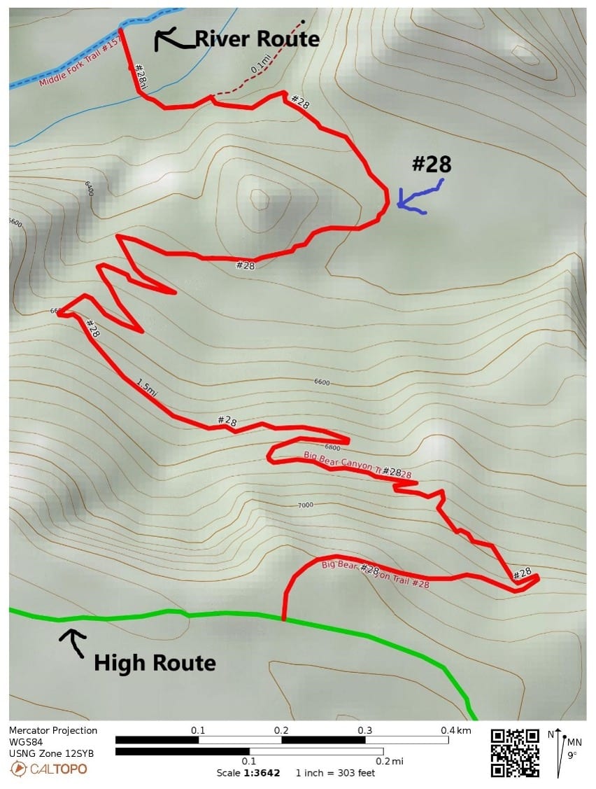
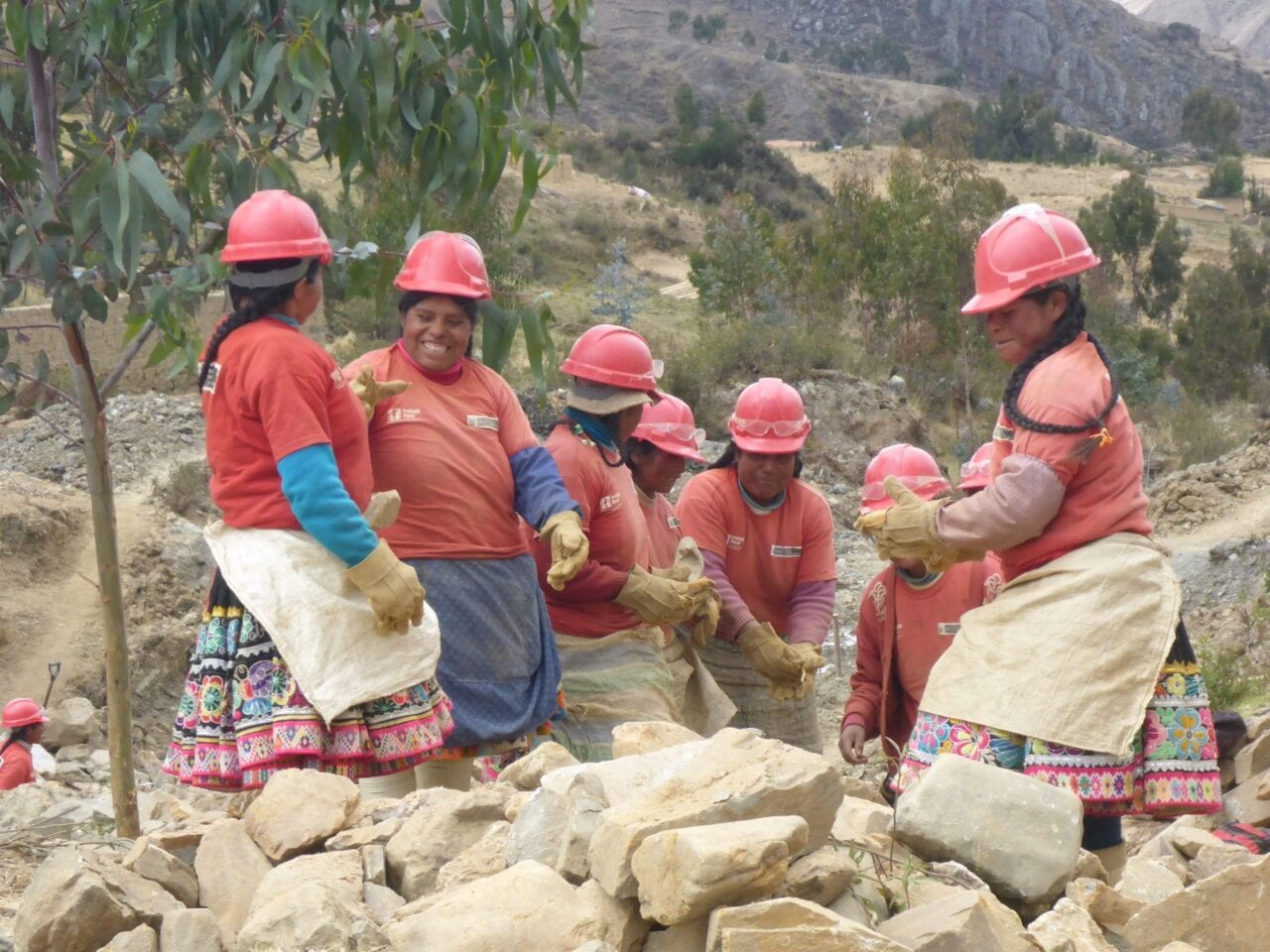
Until now, the CDT alternate in the Gila Wilderness has had two trail options: the “river route” and the “high route.” Now CDTC is adding two more trails to the Gila Wilderness alternates. They improve safety and reduce overuse. The two new trails connect the river route to the high route. One is #28, the Big Bear Trail, and the other is #730, the Coop Mesa/ Garcia Springs Trail.
Melissa Green Trail Information 04/18/2021
Melissa Green
Trail Information
04/18/2021
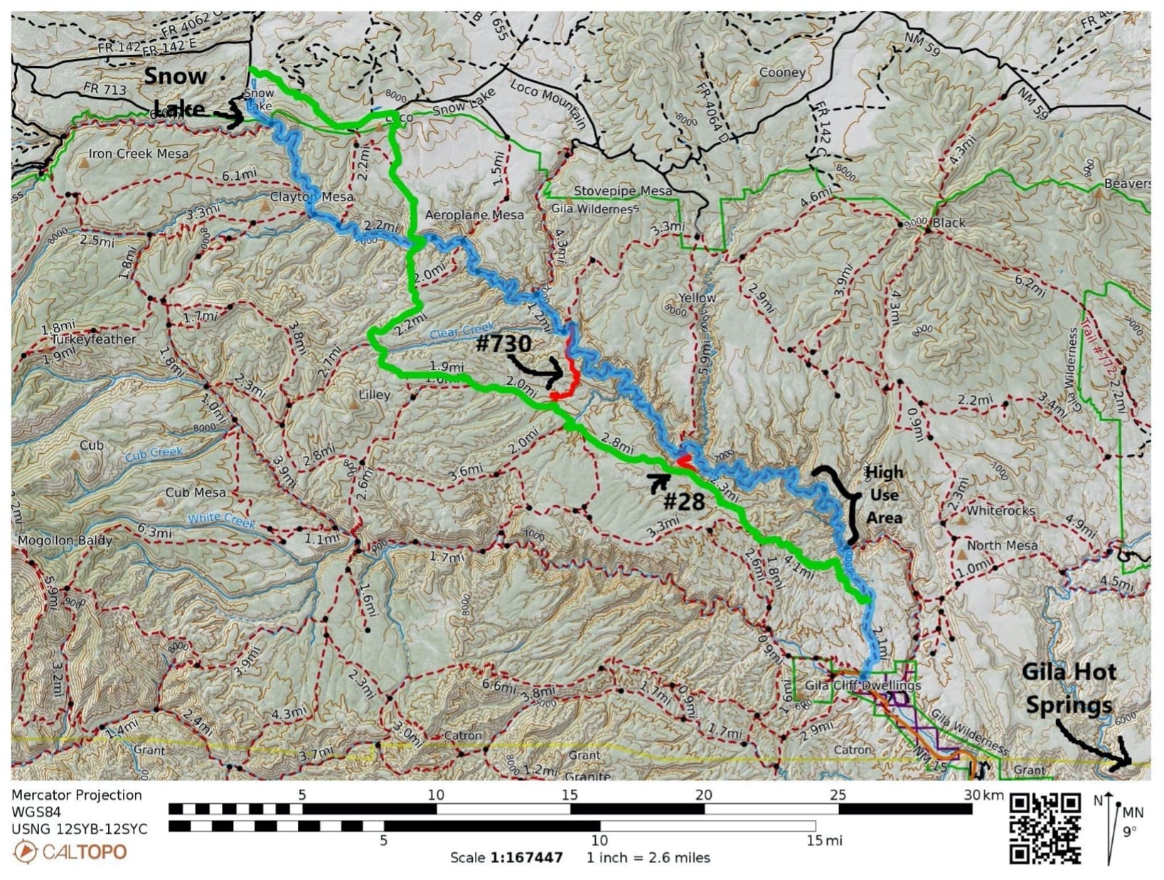
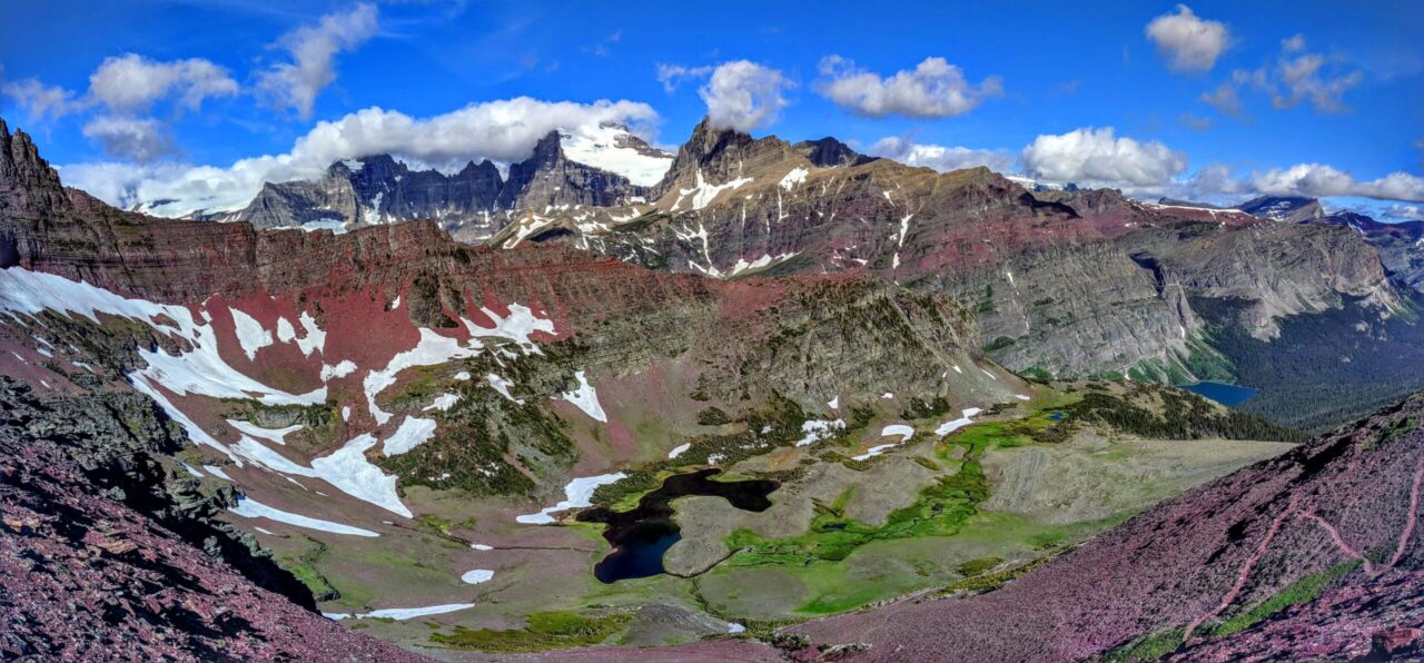
Green highlight:Gila high route, Blue highlight: Gila river route and Red Highlights: new connector trails #730 and #28.
Why add more trails?
1. It improves safety: If you are on the 30 + mile river trail that is slow traveling because of all the river crossing and then the weather changes to very cold or the river starts flooding, you may want a way to escape the river bottom. (These are both common occurrences during the dates that CDT through-hikers travel the Gila Wilderness). Alternately, if you run out of water during a dry year on the high route, you may want to take one of these trails down to the river route.
2. It disperses use: A well dispersed trail system prevents overuse issues and damage to the natural resources. The connector trails provide an option to avoid high use and/or overused areas. The most heavily used area in the Gila Wilderness is the Little Bear trail #729 to Jordan Warm Springs on the Middle Fork (see map above). This is a part of the CDT river route and a part of a popular backpacking loop. You can avoid this section by starting on the CDT high route and then using one of the connector trails to hike down to the river upstream of Jordan Warm Springs. Taking this route helps protect the area and maintain the resource for sustainable shared use.
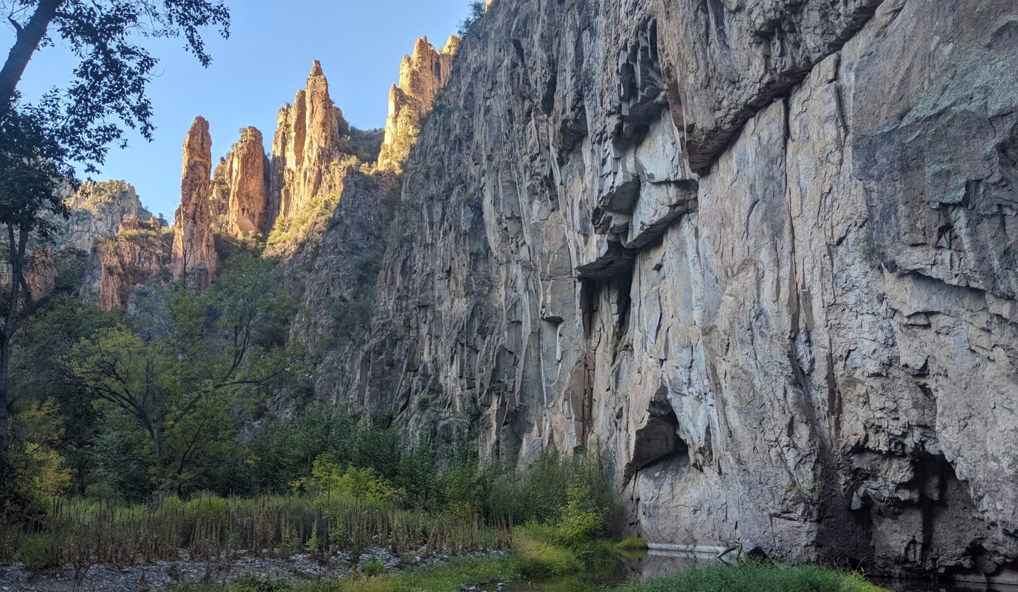
Worried about missing out if you bypass this section? The high use trail to Jordan Warm Springs is not necessarily the most beautiful. In terms of beauty and grandeur, my favorite section of the Middle Fork is between the Meadows (Middle Fork Trail junction with #28) and the Middle Fork Trail junction with Coop Mesa / Garcia Springs Trail #730. (On the map above, it is between the 2 red connector trails).
“But I miss the warm springs” – Warm springs are a treat but this area has multiple hot springs. There are privately owned hot springs at the Gila Hot Springs Campground in the resupply town of Gila Hot Springs. They are CDT-hiker friendly, with clean pools and a well-kept campground. There are adequate facilities to accommodate the use without doing damage to the natural environment. This contrasts with the steep canyon walls at Jordan Warm Springs and inexperienced campers that cause excess feces and trash in the river corridor. So, I would recommend stopping at the private hot springs during your resupply and skipping the Jordan Warm Springs.
About the connector trails:
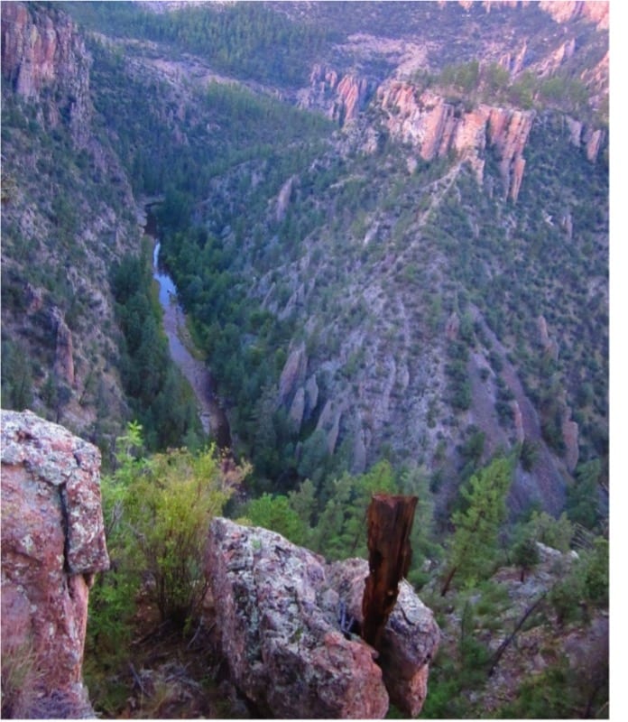
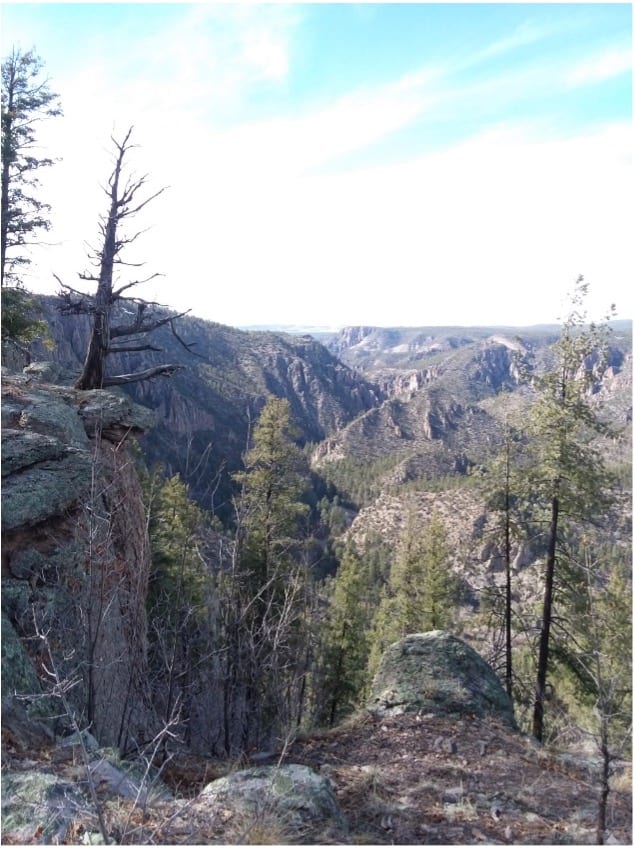
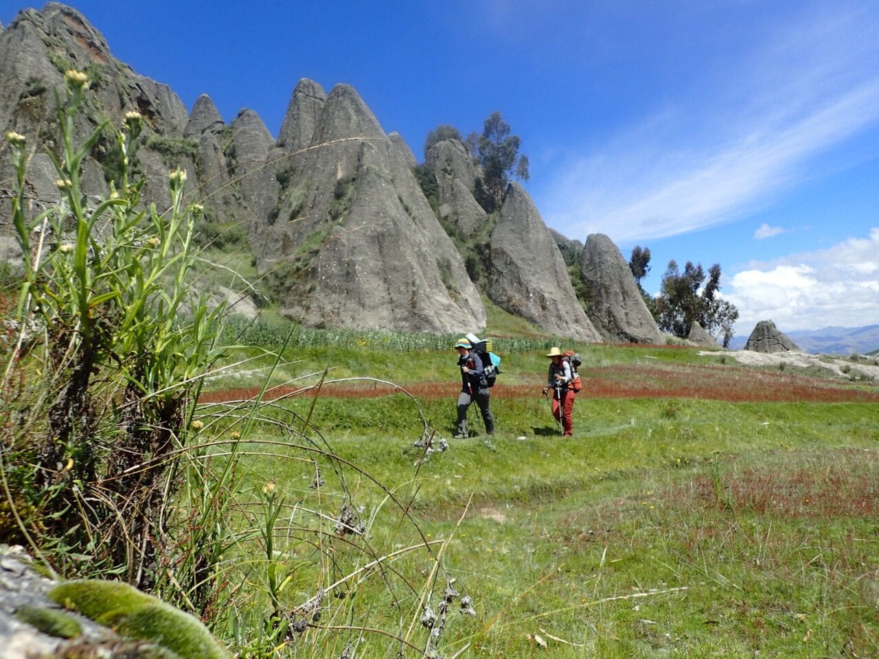
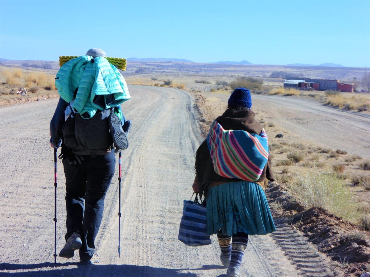
A connector trail could sound like it is unimpressive and just getting you from one place to another. However, these trails offer beautiful views and are worth hiking just to see the terrain they travel through.
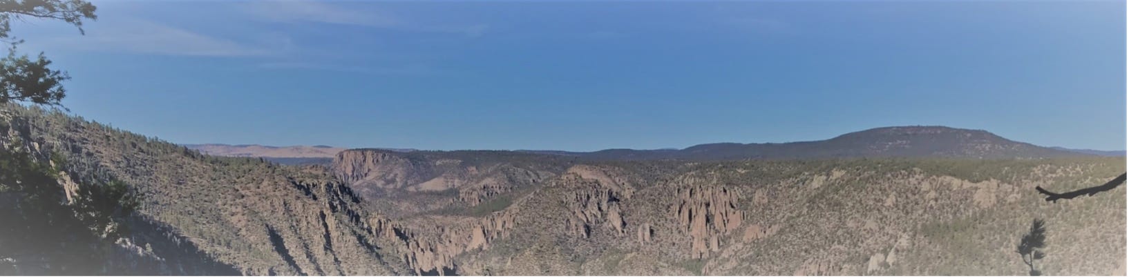
Photo by Melissa Green
Understanding the Gila
I worked on the Forest Service Gila Wilderness trail crew for over a decade. When funding disappeared, I helped create a trails program, which organizes volunteer trail projects and provides trail information in the Gila. I work with Gila Back Country Horsemen who have been doing volunteer trail work for over 17 years.
The trail projects, which benefit all trail users, and Gila Trails Info website aim to disperse trail use and to increase user safety and enjoyment of the Gila. There are so many places in the Gila that are beautiful and have water. There is no reason to over stress one area.
We organize a trail projects with the CDTC in the Gila Wilderness. Check out this year’s project in March on the CDTC website. To receive info on other Gila volunteer trail projects or plan a trip in the Gila – Check out gilatrailsinfo.org.
Read more!
Check out some related blog posts!

Get our trail guide for this area!
Continental Divide Trail
Considered by many to be the most remote and challenging of the triple crown trails, the Continental Divide Trail is a 3100 mile adventure through five western states.
3100 mi (4980 km) $39.99 full guide
Colorado, Continental Divide Trail
Photo by David Getchel
Colorado, Continental Divide Trail
Photo by David Getchel
Continental Divide Trail
Considered by many to be the most remote and challenging of the triple crown trails, the Continental Divide Trail is a 3100 mile adventure through five western states.
3100 mi (4980 km)
$39.99 full guide
Get our trail guide for this area!
About the Author

Melissa Green
Melissa Green has spent many years in the Gila Wilderness including working on the Forest Service Wilderness Trail Crew for a decade. She now leads volunteer trail projects for the Gila Back Country Horsemen in the Gila Region. She has spent much of the past 20 years working in the outdoor industry including leading 3-week backpacking trips for at-risk-youth in Oregon. In her free time, she does trail work in the Gila Wilderness, hikes and runs, works in her garden and does building projects. She is passionate about the Gila Trails and keeping them open for people to find rejuvenation in nature. To this end, she created the Gila Trails Info website which provides updated trail information for visitors and locals.

Highest & Lowest Points on the PCT/AT/CDT
Planning an adventure? Check out our popular trail guides! 4.8 stars (17K+ ratings)
Highest & Lowest Points on the PCT, AT, CDT
What are the highest and lowest points on the Triple Crown Trails (Pacific Crest Trail, Appalachian Trail, and Continental Divide Trail)? Find out by taking a look at our elevation profile data.
Kenna Sarae Kuhn Explore New Trails 10/09/2020
Kenna Sarae Kuhn
Explore New Trails
10/09/2020
Pacific Crest Trail
Highest Point: Forester Pass, California
- 13,153 feet (4,009 m)
Lowest Point: Cascade Locks, Oregon
- 140 ft (43 m)

Forester Pass

Elevation profile of Forester Pass from the Guthook Guides app
Appalachian Trail
Highest Point: Clingmans Dome, Tennessee
- 6,643 ft (2,025 m)
Lowest Point: Bear Mountain State Park, New York
- 124 ft (38 m)

Clingmans Dome
Elevation profile of Clingmans Dome from the Guthook Guides app
Continental Divide Trail
Highest Point: Grays Peak, Colorado
- 14,278 ft (4,352 m)
Lowest Point: Waterton Canyon, Montana
- 2,972 ft (906 m)

Grays Peak

Elevation profile of Grays Peak from the Guthook Guides app
Want to keep up with all that’s going on at Atlas Guides? Sign up for our newsletter!
Read more!
Check out some related blog posts!
Get our trail guide for this area!
Continental Divide Trail
Considered by many to be the most remote and challenging of the triple crown trails, the Continental Divide Trail is a 3100 mile adventure through five western states.
3100 mi (4980 km) $39.99 full guide
Colorado, Continental Divide Trail
Photo by David Getchel
Colorado, Continental Divide Trail
Photo by David Getchel
Continental Divide Trail
Considered by many to be the most remote and challenging of the triple crown trails, the Continental Divide Trail is a 3100 mile adventure through five western states.
3100 mi (4980 km)
$39.99 full guide
Get our trail guide for this area!
About the Author

Kenna Sarae Kuhn
Kenna grew up in Northern California visiting her grandmother’s cabins along the PCT, which helped catalyze her love for the outdoors and interest in backpacking. She is particularly passionate about the intersection between sustainability and outdoor recreation, connecting with womxn and communities that have been historically underrepresented in outdoor spaces, and pesto pasta. You’re likely to find her having an impromptu dance party with her pup, whether it’s while backpacking, climbing, mountain biking, or just on the side of the road.

Fuel Canister Cap? Or No Cap?
Planning an adventure? Check out our popular trail guides! 4.8 stars (17K+ ratings)
Fuel Canister Cap? Or No Cap?
Should you carry the cap that comes with your fuel canister? We describe the reasons you should.
Paul Bodnar Educational 9/5/2020
Paul Bodnar
Educational
9/5/2020
Use the cap: it protects the canister threads and keeps dirt out!
Many long-distance hikers do not carry the cap that comes with the fuel canister in order to save weight. However, the canister cap serves a valuable purpose by protecting the threads of your canister and keeping dirt from entering the top of the fuel canister.
Damaged threads can damage your stove threads when the canister is attached. Cross threading a stove is one of the most common reasons for stove replacement on the trail (which is expensive and inconvenient)!

Clean Threads

Dirty Threads
Any dirt in the top threaded area of the canister will enter your stove when it is attached, which increases the chances of clogging the stove and reducing performance.

You save about 2 grams (the weight of about 2 paperclips) by leaving the cap behind, but the risk to damaging your stove is relatively high. Therefore, I recommend using the canister cap to protect your canister and stove from damage.
Read more!
Check out some related blog posts!
Get our trail guide for this area!
Continental Divide Trail
Considered by many to be the most remote and challenging of the triple crown trails, the Continental Divide Trail is a 3100 mile adventure through five western states.
3100 mi (4980 km) $39.99 full guide
Colorado, Continental Divide Trail
Photo by David Getchel
Colorado, Continental Divide Trail
Photo by David Getchel
Continental Divide Trail
Considered by many to be the most remote and challenging of the triple crown trails, the Continental Divide Trail is a 3100 mile adventure through five western states.
3100 mi (4980 km)
$39.99 full guide
Get our trail guide for this area!
About the Author

Paul Bodnar
Paul has always liked hiking and thru-hiked the Pacific Crest Trail in 1997 after college. After years of working in chemistry, he wanted to create a career involving the outdoors, so he hiked the PCT again in 2010 to do research for his guide book, Pocket PCT. He realized that creating a smartphone app for navigating the outdoors would make it easier to keep the data current and provide a better way to navigate. While hiking with Ryan (aka Guthook) in 2010, they decided to work together to create the first comprehensive smartphone guide for the PCT.
Embrace the Punctuality: Thru-hiking the CDT on a time-crunch
Planning an adventure? Check out our popular trail guides! 4.7 stars (12K+ ratings)
Photo provided by Dahn Pratt
Embrace the Punctuality: Thru-Hiking the CDT on a Time-Crunch
Dahn thru-hiked the CDT in 95 days in between spending six weeks off-trail at four different weddings.
Dahn Pratt Trip Report 06/05/2020
Dahn Pratt
Trip Report
06/05/2020
From late June to early November 2019 I thru-hiked the Continental Divide Trail from Canada to Mexico. Although the time frame of six months looks rather ordinary, I only spent 95 days on-trail, spending six weeks off-trail at four weddings. Getting off the trail for two major breaks made for an interesting and unconventional thru-hiking experience. I learned a lot about myself and my hiking preference from this frenzied hike.
The CDT has a reputation for being a suffer-fest in comparison to other national scenic trails in the United States, often referred to as the PhD of thru-hiking. To complete the trail in under 100 days necessitated averaging over 32 miles a day through often challenging terrain and weather conditions. Perhaps the most difficult part was spending a majority of the time completely alone. Solid weeks would go by of seeing perhaps one or two people, mostly in passing. Some days I would see no one at all.

A rare human sighting in Glacier National Park, MT.
The most difficult part of the hike was not the physical challenges, of which the CDT has plenty, but rather the mental obstacles that are rarely prevalent in our sedentary lives. Lack of comradery for months can really take its toll on you. Humans are social creatures after-all. The ability to commensurate about a harrowing weather experience, atrocious trail conditions, or lack of peanut butter, and celebrate triumphs, gorgeous sunsets, or a really nice spring are part of our shared human experience. The severing of this interaction is very surreal for a mind not adept to seclusion from society.

A brooding sky presents a light show. With no one around to share its beauty, I simply had to smile in silence. Central New Mexico.
Moreover when on a major time crunch, relying solely on yourself for motivation becomes an increasing implausibility. When the weight, magnitude, and sheer length of walking the length of the United States starts to settle in, a dull, but ever present anxiety hovers over every wa(l)king minute, you start to lose your marbles. Perhaps this self-flagellation can be entirely avoided. It is voluntary after-all, or perhaps this is all part of the process of a long walk.
All that being said, this type of self imposed isolation can also be very beneficial. A long distance thru-hike gave me the opportunity to fully immerse into myself, a unique chance to truly get to know oneself.
SOME OTHER BENEFITS OF A FAST THRU-HIKE:
Less time in town
- Increasingly I find myself attempting to escape the grinding banality of modern civilization by retreating into the wilderness. One of the caveats is the necessity of replenishing food, gear, or sleep in towns along the way. On a serious deadline, time not spent hiking looms over you as a wasted opportunity or a potential reason you do not accomplish your end goal.
- Limiting time spent in town is hard on the mind but can greatly increase your daily average mileage.
- Most people are familiar with a “zero” (a day of no mileage, usually spent in town) or a “nero” (a short day into or out of town). On the CDT I tried a first for me, a “hero” (hiking into town, doing necessary town chores, and hiking out), essentially a full day of hiking with a brief town stop. This eliminated the need to linger in town, with all of its temptations, and allowed my mileage average to hardly fluctuate.
Less money spent
- More time spent on trail equates to less opportunity to spend money. I was able to stay solvent during my thru-hike despite a limited budget by never spending a night in town and avoiding restaurants in favor of supermarkets.
More immersed
- Extending time outside the comforts of modern civilization allowed for a more holistic experience of nature.
- Limiting distractions allowed for a level of introspection I seldom have with the chaotic and interconnected “inside” world.
- This immersion allowed and even necessitated a trust of self, as there was no one else to rely on. This made me fundamentally optimistic — you have to be when you’re completely isolated from the rest of society.
- Immersion also exposed the true scale of one’s surroundings. A recurring thought was, “it’s so vast out here that my problems don’t take up any space.”
- Taken as a whole, this immersion peels back the layers of self defense mechanisms and societal conformities to reveal that the mask disappears and you transform into your true self. A powerful understanding of your own identity.

Fully immersed while sauntering through the jaw-dropping Wind River Range of Wyoming.
Goal oriented
- Being on a tight hiking timeline necessitates great discipline. Everyday is an exercise in fighting off the ideas of futility. Being able to self motivate and actualize are skill sets that are transferable but can also be honed while hiking a long trail.
- The routine one creates while on a trail — waking up early, limiting breaks, pushing the pace — are a constant act of discipline. Aristotle famously said, “We are what we repeatedly do. Excellence then, is not an act, but a habit.”

Walking by sun-up ensured I had a minimum of 12-14 hours of moving time. Wyoming/Colorado Border.
All of that being said, my big epiphany from this long walk was that true appreciation of the enormity and beauty I was privileged to explore was not fully maximized with my constraints of arbitrary timephrames. I am reminded of a powerful saying from an old and rarely explored Camino (pilgrimage trail) called Via Francigena:
The route, like life, is not a competition. Never get seized by the wish to do too much: your body will soon demand an explanation. Look around, observe, stop and taste. That’s what the route will teach out.

Taking a chance to “stop and taste” some foraged wild morels from a wildfire burn area in Idaho.

Sometimes you have to stop and smell the sulfur. Yellowstone National Park, WY.
Taken as a whole, hiking with a time constraint has some definite beneficial qualities, but if your purpose and passion for recreating in the outdoors is to immerse, explore, and be unhindered from the chaotic society you’ve momentarily escaped from, the idea of a deadline is detrimental to the experience. More often, I find myself suggesting the idea of section hiking, where time and distance play a much smaller role in the adventure you choose to take. Big miles and aggressive hiking is a great bragging right but it’s not the only way to Hike Your Own Hike.
Want to keep up with all that’s going on at Atlas Guides? Sign up for our newsletter!
Read more!
Check out some related blog posts!
Get our trail guide for this area!
Continental Divide Trail
Considered by many to be the most remote and challenging of the triple crown trails, the Continental Divide Trail is a 3100 mile adventure through five western states.
3100 mi (4980 km) $39.99 full guide
Colorado, Continental Divide Trail
Photo by David Getchel
Colorado, Continental Divide Trail
Photo by David Getchel
Continental Divide Trail
Considered by many to be the most remote and challenging of the triple crown trails, the Continental Divide Trail is a 3100 mile adventure through five western states.
3100 mi (4980 km)
$39.99 full guide
Get our trail guide for this area!
About the Author

Dahn Pratt
Dahn was a 2019 Data Fellow for the CDTC, collecting trail data while thru-hiking from Canada to Mexico. Hiking the CDT was part of a larger project, “Chasing Summer”, a 10,000 mile journey through various national scenic trails all over the world.
(Don't) Hike for Change featuring Fidgit
Planning an adventure? Check out our popular trail guides! 4.7 stars (14K+ ratings)
Photo provided by Bethany Hughes
(Don't) Hike for Change
Fidgit examines decisions to postpone or cancel a long distance hike through the lens of ancient Central and South American mythology and a 20,000 mile trans-American journey.
Bethany Hughes My (Postponed) Trail Story 04/20/2020
Bethany Hughes
My (Postponed) Trail Story
04/20/2020
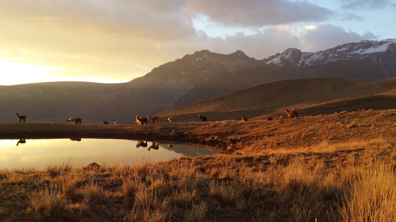
Alpacas at sunset in the Huayhash range. Photo by Bethany Hughes
(Don’t) Hike for Change
By: Bethany ‘Fidgit’ Hughes
Do you remember when people thought the world was going to end in 2012? The idea stemmed from the end of several Mesoamerican calendars. What the frenzy failed to do was what most frenzies fail at: following the information all the way through. The conclusion of the calendars marked transitions in eras, not the end of the world. As I look around now and back over the past few years, the changes and stressors are notable but nothing unexpected if we perceive this as a time of change.
Everyone goes to Machu Picchu, yet we had the entire grounds of the Inca ruins at El Shincal in Argentina to ourselves and the groundskeepers even let us sleep on their porch.
The end of the Mayan and Incan calendars marked the end of protracted cycles. For the Mayans it was one of 7 Ages of Man. For the Incas it was the end of an era ruled by “masculine energy” and the beginning of an era of “feminine energy.” That these transitions happened around December 21 makes sense since both cultures, like many around the world and across the ages, track the solstices. For example, even among the thru-hiking community, we ceremoniously engage in Hike Naked Day every June 21st.
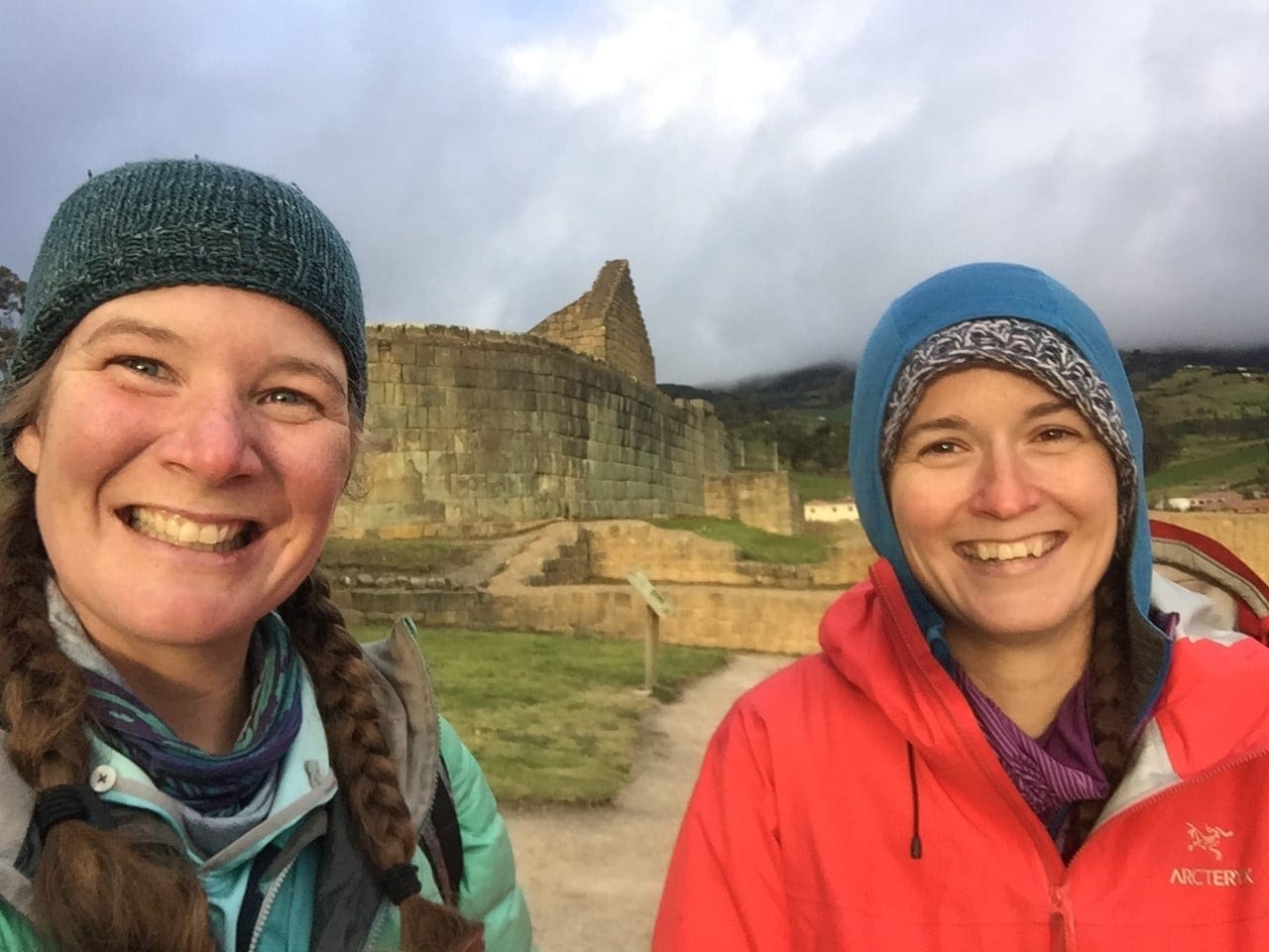
Fidgit (left) and Neon (right) at the Ingapirca ruins in Ecuador which are ceremonial grounds for two different cultures: the Cañari who worshiped the moon, and the Inca who worshiped the sun. There is an incredibly well preserved and largely ignored multi-day stretch of the Qhapaq Nan which begins at this site.
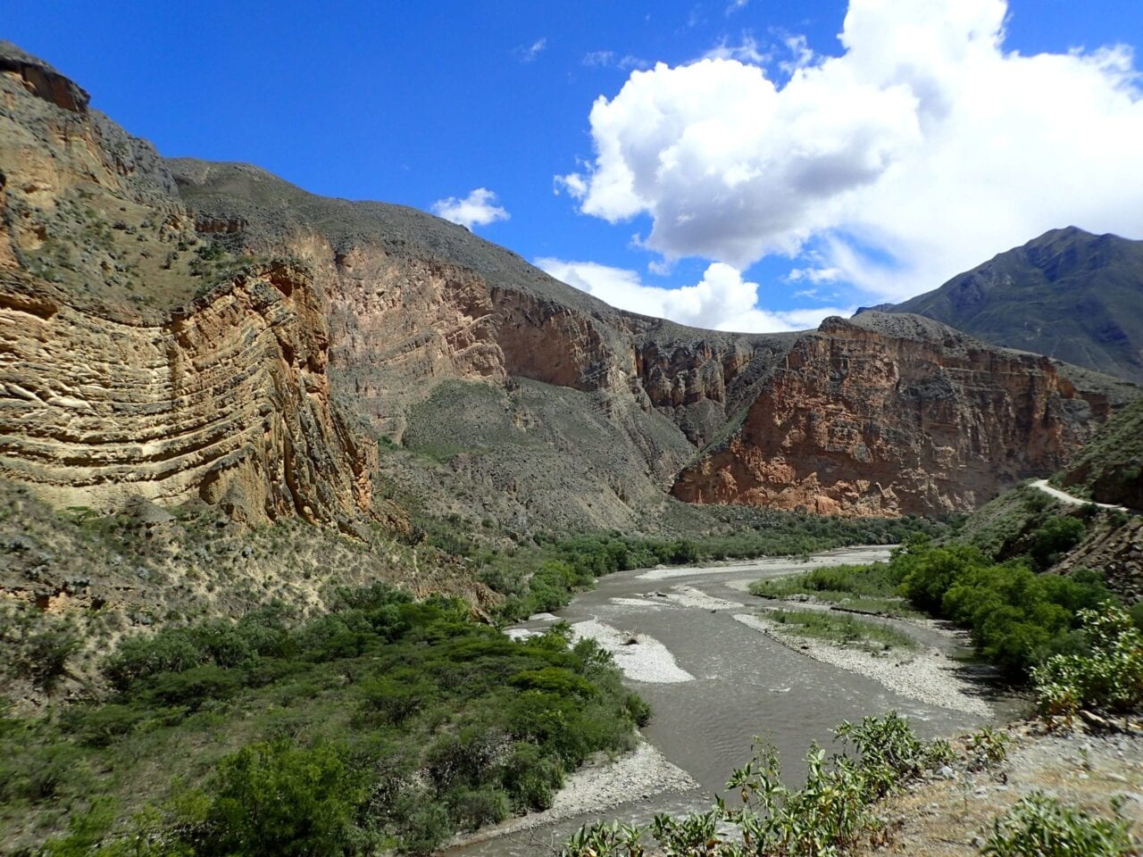
My sources on that aren’t of an academic nature, they come from three years of walking across South America. They are stories and explanations from a grandmother at the foot of Ollantaytambo, Peru who, when I picked up one small rock from her table, carefully selected and insisted I take a second one, to balance their male and female energies. Or from days of walking and talking with chaskis (during the Incan Empire chaskis were runners who carried messages from the capital[s] to the far flung corners of the empire. The men I spoke with were modern day guides and unofficial guardians of segments of what remains of the Qhapaq Ñan) along the 3,000 miles of the Inca Trail we followed. Complemented this with some Googling. That and a lot of miles of walking, thinking, and watching as we strive to create a non-motorized route connecting the Americas.
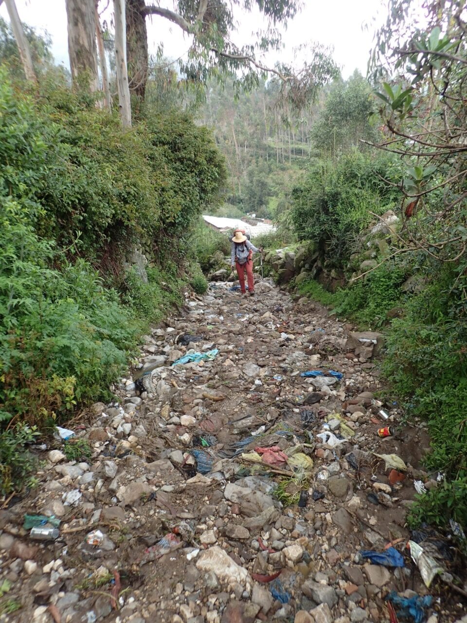
Because of being such a deeply entrenched footpath after centuries of use and despite being a UNESCO designated World Heritage Site, outside of cities and towns the Qhapaq Nan is most often used as a dump site.
In my final days of completing the Continental Divide Trail last summer, I crossed paths with Dahn, a fellow long traveler. We had been following one another’s international hiking adventures and had been trying to meet up, so of course it didn’t happen until the last 100 miles. In the few hours we walked together, we had one of those conversations that only happen on trail: diving straight into debating ethics and what kind of faces we make at cars on road walks.
I told him about the Incan idea of the calendar shift of power from masculine to feminine. He began to speak passionately about the rise of women, saying it was time for things to change! Frustrated that we haven’t had a woman President in the USA. There was a fervent bounce in his stride as he talked about it. If it’s our time, we need to rise up, RIGHT NOW and seize control.
The best things take time and immense pressure and sudden changes leave beautiful marks.
We sat in front of Saucedo’s Market in Lordsburg taking swigs off a jug of orange juice and eating bananas. I appreciated his vehemence and commitment to pursuing equal rights. I just did not agree with his perception that the change needed to happen abruptly. Rather, I thought our having that conversation was a significant indicator that things are changing. In fact, several times along the CDT I was impressed and inspired by the men I hiked and talked with who were reflecting on their personal roles and seemed genuinely committed to growing and changing, even where it meant questioning familiar structures designed to benefit them.
In our earliest roles, men were successful as hunters because of: having singular focus, designating a leader, and tracking, attacking, and conquering game. Meanwhile the women were primarily gatherers and were successful because of observing surroundings as a whole, following growth cycles, and working as a collective to gather foods. It does not serve to pick a berry before its time. We grow humans within our wombs. These processes cannot be rushed.
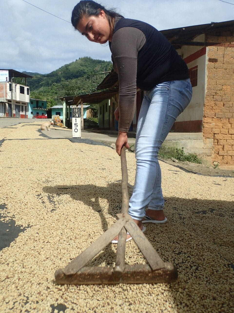
Chatting with a local woman who was caring for her coffee beans during the multi-day drying process. Coffee is a major industry, much like quinoa, throughout this region of Peru.
The geopolitical and economic structures today are geared toward the hunter, big dog on top, thinking. We have been raised with scripts of:
“if you want it, grab it.”
“You have to want it more than the next guy.”
“Don’t let anything stand between you and your goals.”
Now more and more of us are looking around and acknowledging that this is not working. Not for our planet and not for us.
Learning bits of Quichua from cholitas in the Cusco region.
This is the end of the era of conquistadors and Victorian explorer thinking. Being first or fastest is less a matter of dominating one another and the land, than it is about expanding the bounds of what we can achieve when we work with each other and the environment. Minorities are stepping forward and making their voices heard in communities and conversations across the board. I am encouraged to begin seeing people of privilege supporting this and amplifying the message. Underneath the ills of our systems, down here at the dirt sitting hiker trash level, many people are making an effort to hear one another and are considering different perspectives. That is a big deal and a good start.
Fidgit (left) and Neon (right) with one of the many families who invited us in and insisted on sharing everything they had.
In the thru-hiking community, we identify by our determination, overcoming challenges, and pushing limits in pursuit of the coveted thru. The current state of human affairs, and in a larger perspective, the planet, are a mighty invitation to rewrite that narrative. Flip flopping because the snow in Colorado says “no.” Taking an alternate or following a reroute because of a forest fire. Changing our plans from a thru-hike to smaller adventures closer to home because of a virulent virus. Nature is pushing us, not to give up, but to reframe our identity to another critical strength: flexibility.
Neon following the Qhapaq Nan along the contour of the Andes.
That same demand to drastically change plans and let go of ego is at play this season with the quarantine efforts which, for many of us, are a direct call to set aside our wants and goals in the interest of others. As the call goes out to stay off the trails to honor our trail communities, thousands of us have made difficult decisions and huge sacrifices in our hiking plans. My travel partner and I made the choice to pull off mid-route in Mexico. Sure, there are yet a few who, for reasons of their own, are out there anyway. Rather than give our collective time and energy to being upset about them, let’s acknowledge and celebrate the fact that the majority of us opted to sacrifice. That means something.
While the theatrics of social media are particularly alluring when you are frustrated to be stuck staring at a screen instead of climbing a mountain, this is yet another chance to change the narrative by not giving in to the bickering and the bitterness. The information, reasons, and requests to stay off the trail are out there. Hounding each other does not add anything to the conversation.
The ancient road was so well developed and traveled that in many areas beyond the reaches of the cities, the road continues clearly and follow toward beautiful passes. Fidgit (left) Neon (right)
Amidst the mess: politics, climate change, and the global responses to this virus, I see the power shifting from conqueror to community. Let’s not underrate that just because it isn’t happening in the same way or at the same pace as our history books have seen change of power before. Women and minorities in general are not weaker because we approach things differently. We are not passive, fragile, or fearful. We know trauma and physical hardship beyond what any trail can wrought. We are determined, adamant, and we are rising.
A section of road had been obstructed by a landslide and outside help was not coming so the local women organized themselves. There was a lot of laughter and tittering as they worked.
I see a fit for the Incan dichotomy of a shift in the balance between masculine and feminine energies. I see harbingers of change between lines of thinking and how we approach one another. Do not be ruled by fear nor anger and do not rush but let us hurry into the work of our lives. We may not be thru-hiking at the moment but change is afoot.
“We’re all just walking each other home.” Ram Dass
Want to keep up with all that’s going on at Atlas Guides? Sign up for our newsletter!
Read more!
Check out some related blog posts!
Get our trail guide for this area!
Continental Divide Trail
Considered by many to be the most remote and challenging of the triple crown trails, the Continental Divide Trail is a 3100 mile adventure through five western states.
3100 mi (4980 km) $39.99 full guide
Colorado, Continental Divide Trail
Photo by David Getchel
Colorado, Continental Divide Trail
Photo by David Getchel
Continental Divide Trail
Considered by many to be the most remote and challenging of the triple crown trails, the Continental Divide Trail is a 3100 mile adventure through five western states.
3100 mi (4980 km)
$39.99 full guide
Get our trail guide for this area!
About the Author

Bethany ‘Fidgit’ Hughes
Bethany ‘Fidgit’ Hughes is one half of the Her Odyssey duo. She and Neon have covered 13,000 of the proposed 20,000 mile journey crossing the Americas by non-motorized means. They would love to have you join the journey on any of the platforms below:
YouTube- https://www.youtube.com/channel/UCrSuZIGMOsyZILcYtR1bcRA
Instagram- https://www.instagram.com/_herodyssey_/?hl=en
Facebook- https://www.facebook.com/herodyssey/
My (Postponed) Trail Story by Cyclops and McGoober
Planning an adventure? Check out our popular trail guides! 4.8 stars (17K+ ratings)
Photo provided by Chris and Kimberly
My (Postponed) Trail Story by Cyclops and McGoober
Chris and Kimberly, a.k.a. Cyclops and McGoober, were getting ready to start their thru-hike on the Continental Divide Trail when they made a hard decision to postpone their hike.
Natalie McMillan My Trail Story 04/08/2020
Natalie McMillan
My Trail Story
04/08/2020
CDT 2020! That was the answer for the past 2 years that we (Cyclops and McGoober) would give to the question “Well, what’s next?” since we completed the PCT in 2018. It was the obvious choice for any thru-hiker who has already completed the Appalachian Trail and Pacific Crest Trail. The Triple Crown was in our sights, something we had set out to accomplish years before, it was right there and all we had to do was hike, or so we thought.
Photo by Chris & Kimberly
Like planning for any thru-hike, we had a few challenges along the way. We were expanding our use of social media and working with sponsors and blogs for the first time. These were all headaches that one could expect but overall things were going as planned. When we first started hearing about COVID-19, our only thought was, hopefully we can get out on trail before this starts to spread. Like most people early on, we thought the trail would be the best place to avoid a sickness- there won’t be many people, we’ll be isolated, and as long as travel isn’t restricted we’ll be fine.
Photo by Chris & Kimberly
This was all in early March, about a month away from our last day of work before we took a few weeks to see friends and family before shipping off to New Mexico. Soon, we started reading more about how the virus was spreading and affecting so many communities. We then started thinking, should we push up our start date and get out there sooner? Maybe we shouldn’t see our parents; they are in the “at-risk” age group. Everything was happening so fast that our minds felt like a whirlwind. We ordered our last few pieces of gear the same week we found out that our places of business were in danger of closing. At that time the CDT was recommending rethinking your hikes but still offering shuttle services to the Southern Terminus, so we figured we could still swing it but we weren’t going to risk bringing anything down to our family before we left. The plan was still, if we can get out there we’re going to go. We planned, saved, sublet our apartment, and dreamt about this for years. It was happening dammit.
Photo by Chris & Kimberly
Those questions and thoughts racked our brains for what felt like weeks but could only have been a matter of days. It seemed to turn our nightly routine into a stress filled argument about: what to do, what was the plan, and can we afford to quarantine if we get sick out there. Then it finally hit us. If we were worried about bringing something to our parents or catching something on the flight out and getting sick in the middle of nowhere, then why were we going?
Isn’t it a bit unfair for us to protect our parents by staying away while possibly infecting someone else’s parents in a far more remote town with far less resources? Is it fair to possibly put the stress of first responders to come drag our stubborn asses out of the Gila National Forest, wasting valuable resources? We decided on the only answer that made sense to those questions. It’s time to postpone.
While the decision was an incredibly difficult one to make, years of planning, thousands of dollars of gear, giving up our apartment, but in the end it felt like the weight of the world was off our shoulders. The very next day, our last at work due to working at non-essential businesses, we knew we made the right choice when the Appalachian Trail Conservancy, Pacific Crest Trail Association and Continental Divide Trail Coalition came out with recommendations for postponing thru-hikes.
Photo by Chris & Kimberly
Things seem to have slowed down quite a bit since making the call to postpone. We did luck out in a few ways like having understanding subleasers who found another place to live. We are very thankful to be living in a small town in Vermont during this time to keep our minds and bodies active. We live just six miles from a Long Trail trailhead so we are still able to get out and hike while maintaining a proper social distance. While we have an awesome natural place to live and spend time getting through this pandemic, it still doesn’t compare to our CDT dreams. For those who have thru-hiked before, you know the feeling of post-trail depression. It seems COVID has brought the post-trail blues without the trail. Thankfully, we have been through those blues before and have each other to lean on. We also know that the best way past those blues is to stay active and plan the next adventure.
This doesn’t mean we are giving up on our dreams, the trail will be there, and our gear won’t go bad in the closet for a year. Heck, however unlikely, this could be over for SOBO season. There is no reason to put yourself or others at risk so stay off the trail. The trail could definitely use a year off too.
Photo by Chris & Kimberly
Want to keep up with all that’s going on at Atlas Guides? Sign up for our newsletter!
Read more!
Check out some related blog posts!
Get our trail guide for this area!
Continental Divide Trail
Considered by many to be the most remote and challenging of the triple crown trails, the Continental Divide Trail is a 3100 mile adventure through five western states.
3100 mi (4980 km) $39.99 full guide
Colorado, Continental Divide Trail
Photo by David Getchel
Colorado, Continental Divide Trail
Photo by David Getchel
Continental Divide Trail
Considered by many to be the most remote and challenging of the triple crown trails, the Continental Divide Trail is a 3100 mile adventure through five western states.
3100 mi (4980 km)
$39.99 full guide
Get our trail guide for this area!
About the Author

Natalie McMillan
Natalie grew up hiking in Arizona where she fell in love with the outdoors. Her favorite hikes are to Havasu Falls in the Grand Canyon and Angel’s Landing in Zion National Park, UT. She loves taking pictures of people, places, and nature, which might explain why she has almost 47,000 photos currently residing on her phone. She takes care of all things related to social media and marketing and recently moved to Denver, CO from Flagstaff, AZ. You may find her frolicking around the trails and mountains of Colorado, or exploring the new city she gets to call home.

Thru-hiking Gear Review - Deschutes Zero-G Shelter
Planning an adventure? Check out our popular trail guides! 4.8 stars (17K+ ratings)
Photo provided by Dahn Pratt
Thru-hiking Gear Review: Deschutes Zero-G Shelter
On the Continental Divide Trail unpredictable weather conditions necessitate choosing gear wisely. A Triple Crown hiker explains his decision to bring a Deschutes Zero-G shelter on his 2019 thru-hike of the CDT.
Dahn Pratt Gear Review 03/20/2020
Dahn Pratt
Gear Review
03/20/2020
10,000 miles of Thru-Hiking
Gear; Deschutes Zero-G
Without much practice or knowledge of free-standing tarp-style shelters I brought what amounted to a thin sheet of fabric on my thru-hike of the infamously grueling Continental Divide Trail, a 3,000 mile hike from Canada to Mexico. It was my first foray into the ultralight textile known as Dyneema Composite Fabric (DCF), also known as cuben fiber, but the lightweight fabric proved to be the best piece of thru-hiking gear I used in 2020.
DCF is quickly becoming an essential item on any thru-hiking gear list, and as the popularity of the trails grow, the use of ultralight backpacking gear has also increased. Prior to my hike on the CDT, I was dubious of the practicality for such an expensive fabric. But within the first week of using it, I was a convert.
After a grueling day in the Bob Marshall Wilderness, with over 17,000 ft of elevation gain and 37 miles of tough trail, I settled in for the night, completely spent. It wasn’t my intention to go so far in a single day, especially since I was less than a week into my thru-hike of the CDT. But circumstances dictated I push on, as a majority of the day’s walk was spent above tree-line in very exposed terrain.

The southern end of the Bob Marshall Wilderness aka “The Bob” one of the most remote places in the contiguous US. Photo by Dahn Pratt
Just as the day was ending a thunderstorm began to brew overhead. This was a signal it was time to get somewhere relatively safe.

Photo by Dahn Pratt
As the blue skies turned to an angry gray, my hiking partner and I quickly descended from the exposed ridge to the relative calm of the lower elevations.
A small seasonal alpine tarn near Caribou Peak provided the first tree-cover for miles in any direction. The relief of being under some sort of cover for the first time during the moody weather I had come to expect from Montana was definitely welcomed.

Photo by Dahn Pratt
We had just enough time to crawl into our shelters before the skies began to unload on us. Quarter sized bullets of hail and ear-shattering thunder had me in a fetal position most of the night as frequent and terrifyingly close lightning lit up the interior of my tarp. The barrage lasted several hours and the fear of getting hit by lightning, having my shelter torn to shreds by hail and wind, or having a tree collapse on me all but insured a sleepless night.
In the morning we awoke to a calm, cloudless sky and my hiking partner Vortex looked at me perplexed. There were shards of glass around both of our shelters. A particularly large piece was near where my head had laid the previous night. We had cleared the site prior to putting our tarps down, which had become our thru-hiking ritual, and were dumbfounded to find the glass in our respective sites. Could we really have missed these sharp pieces of glass? We would later find out that the lightning strikes had hit the sandy beach of the small lake we slept beside, fusing the sand into silica glass.
From that day forward, I knew my shelter was bomb-proof!
The Deschutes Zero-G is a DCF shelter with a stated weight of 8 oz (226 grams) although my scale read 222 grams or about 7.8 oz (including the stuff sack but excluding stakes and pole).

Photo by Dahn Pratt
The set-up is pretty intuitive as the shelter only uses a single pole, which was a major draw for me (I have a tendency to snap trekking poles). Even with no real tarp experience, my first time setting it up took ~5 minutes to get a taught pitch.

Quick, easy, and taut pitch, everytime! by Dahn Pratt
Deschutes Zero-G + SerenityNet inner. A fully enclosed double-walled shelter at 19 oz. Photo by Dahn Pratt
Using a piece of Tyvek as a groundsheet and a SMD Serenity Net provided me with a fully enclosed double-walled shelter. The added benefit being the modular nature of having a detachable inner for clear nights or just the Deschutes for bugless nights.
One of the reasons I absolutely loved the Deschutes was its ability to pitch in precarious spots. With its tiny footprint, most sites that would otherwise be off-limits to other hikers were perfect “nests” for me.

After crossing the Wyoming/Colorado border the deadfalls limited safe camping areas, but it had no material impact on the small footprint my Deschutes took up
Photo by Dahn Pratt

With nowhere flat and plantless to set up in the Great Divide Basin, I had to set up shop on a seemingly endless dirt road.
Photo by Dahn Pratt
After proving its worth in the berserk weather of the Divide, I spent the next ten months across seven countries and 5,000 miles with the Deschutes Zero-G as my roof. Completing a year of back-to-back thru-hikes made me more comfortable and well versed in the outdoors than ever before. With this new-found sense of confidence and the Deschutes in my pack, I never doubted its ability in any condition. The increasingly precarious and outright ridiculous places where it was able to perform exceptionally well warranted its new nickname as my “all-terrain vestibule”.

The Deschutes Zero-G in an epic off-trail campsite in sub-Antarctic Patagonia.
Photo by Dahn Pratt

Even with furious winds and constant rain I always stayed dry and cozy inside my “hiker’s nest”. Photo by Dahn Pratt
Author’s disclaimer: This tarp was given to me by Six Moon Designs as part of their Ambassador’s program in 2019
Want to keep up with all that’s going on at Atlas Guides? Sign up for our newsletter!
Read more!
Check out some related blog posts!
Get our trail guide for this area!
Continental Divide Trail
Considered by many to be the most remote and challenging of the triple crown trails, the Continental Divide Trail is a 3100 mile adventure through five western states.
3100 mi (4980 km) $39.99 full guide
Colorado, Continental Divide Trail
Photo by David Getchel
Colorado, Continental Divide Trail
Photo by David Getchel
Continental Divide Trail
Considered by many to be the most remote and challenging of the triple crown trails, the Continental Divide Trail is a 3100 mile adventure through five western states.
3100 mi (4980 km)
$39.99 full guide
Get our trail guide for this area!
About the Author
Dahn Pratt
Dahn is an avid taker-of-walks. He has hiked the Triple Crown of National Scenic Trails in the United States, Te Araroa in New Zealand, the Peace Trail through Jordan and Israel, and various other routes and trails around the world. His most recent escapades called “Chasing Summer” had him hiking long distance trails, oscillating between North and South Hemispheres in perpetual summer.
My Trail Story by Jim Murphy
Planning an adventure? Check out our popular trail guides! 4.8 stars (17K+ ratings)
Photo by Jim Murphy
My Trail Story featuring Jim Murphy
Jim Murphy took a wrong turn in the Bob Marshall Wilderness, walked straight into a forest fire, and shares the story of how he survived.
Natalie McMillan My Trail Story 03/21/2019
Natalie McMillan
My Trail Story
03/21/2019
The Fastest Three Miles I’ve Ever Hiked
By: Jim Murphy
Age: very late sixties
AUGUST 23:
A week or so after leaving the Swift Dam trailhead, I stop by the Gooseberry guard station (a little north of the above map) and check in with a couple of USFS firefighters from New Mexico: Gordo and Brian.
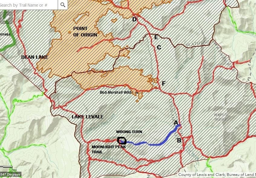
They’re staying at the cabin and hiking up a ridge each day to keep an eye on the Scalp Fire. Started by a lightning strike just a few days earlier, this fire is named after Scalp Creek, the topographical feature nearest to the point of origin. Gordo, the guy on the left in the photo below, with eight years experience, told me, “It’s doing what they want it to do,” and not showing any sign of getting out of control. I told them where I was headed — up Clack Creek to Dean Lake and points south, i.e., the (red) trail on the westerly side of the map, and that I expected to be looping back through in a week or so. They said there was nothing to be concerned about – then. Note that the fire perimeter shown on this map is much more recent, as of a day or so after I got out; at the time of my conversation with the firefighters, it was not much bigger than the star on the map labeled “Point of Origin.”
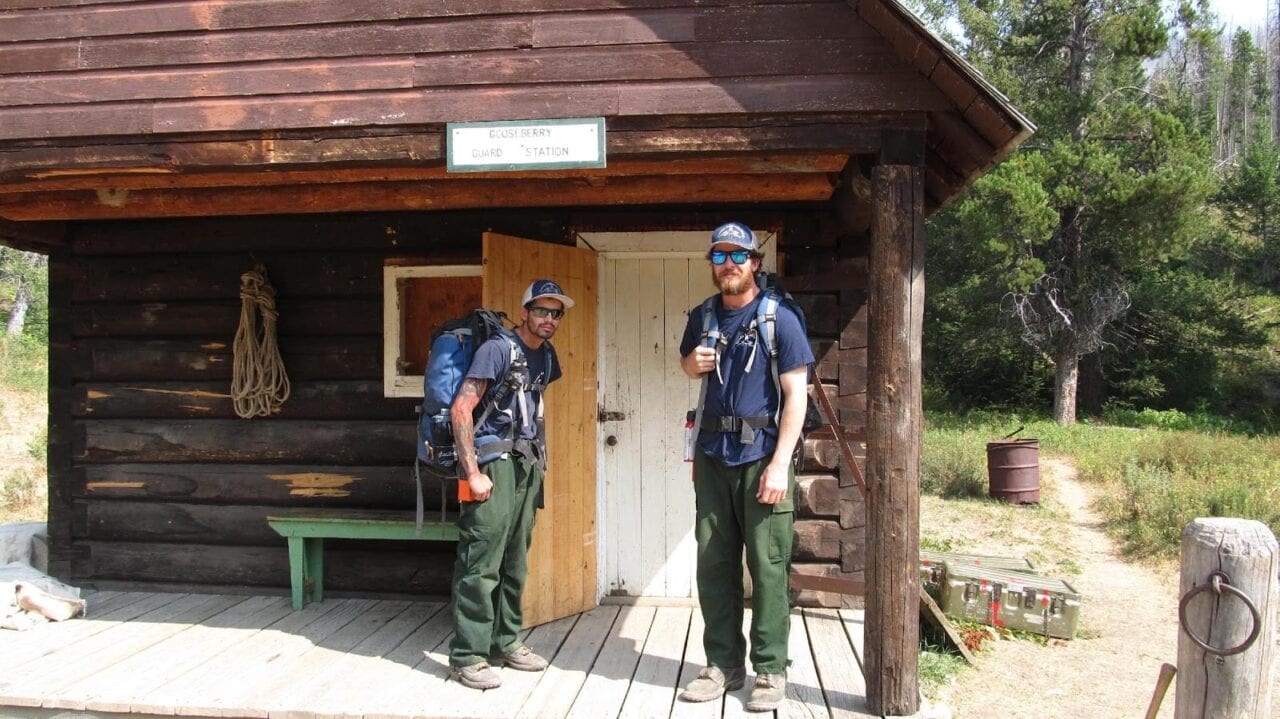
Gordo and Brian.
Photo by Jim Murphy
August 30:
Of course, in the world of forest fires, a week is a lifetime, and things can and do change. After hanging out at a couple of my favorite lakes, Dean and Levale, watching mountain goats, and – this turns out to be important – having encountered no humanoids and therefor having no updated fire info beyond what I got from Gordo and Brian at the cabin a week earlier, I head south on the North Wall Trail, and then east on the Moonlight Peak Trail. This trail is designated by the Forest Service as “Not Regularly Maintained,” which means that they don’t go out and clear all the dead trees that have fallen across it during the winter, and, importantly to this epic, the trail may get a little faint here and there. So I knew what I was buying into when I chose it, but I like these trails nonetheless, as you meet very little foot traffic and virtually never any horses or mules – always a good thing from the backpacker point of view.
Everything is wonderful until I come to a fork in the trail that’s not on the map. After some deliberation, and scouting the right-hand fork for a couple of hundred yards, I decide that the right-hand fork, which seems narrower and just generally of a different character than the left, is probably one of those side trails that go either to a camp used by outfitters, or to a nearby lake (Lake Quiet) that appears on the USFS map (not on the map above). I remember thinking that Yogi Berra, one of my heroes, wrote a book entitled When You Come to a Fork in the Road, Take It!, but that advice didn’t really help me much at that particular point.
I continue along the left fork for what seems in retrospect to have been upwards of an hour. I’m stepping over some deadfall, but as I say, that’s to be expected on a trail that isn’t regularly maintained, so I keep going. Eventually, the deadfall gets ridiculous, the trail goes from faint to non-existent, and I realize that I’ve taken a wrong turn – as I so often have in my life – but this time in the literal rather than figurative sense. Even Robert Frost probably didn’t contemplate the kind of jackpot I’d just gotten myself into when he talked about the road not taken.
I can hear you thinking at this point, “Why didn’t he just backtrack to the fork in the trail?” I would have, except that I’d stayed with this phantom trail for so long, continuing on in the direction that the terrain suggested the trail ought to be, that I couldn’t find the trail when I decided to turn back. Life is hard, but it’s harder when you’re dumb.
So what to do? The creeks and rivers don’t show on the above map, but I was in country that I knew drained in an easterly direction into the North Fork of the Sun River, the trail next to the North Fork being part of my planned route. So, I just find some water and follow the flow down to the North Fork, which was where the Moonlight Peak trail would have taken me if I hadn’t been dumb enough to lose it, right? Easier done on a map than on the ground. I find a very small creek and take off, cross-country, toward the North Fork (Point “A” on the map), not at all clear as to how far away that is. My route, such as it was, is designated on the above map by the blue line; the red line is the actual trail, which I should have still been on. I spend the rest of the day bushwhacking through pretty dense understory, keeping the little creek within hearing, if not always in sight, eventually camping for the night when I run out of daylight.
Photo by Jim Murphy
August 31:
I get up and get back at it, thinking how much more of this can there be? I eventually come out of the woods into the old (1988) burn that has left mile upon mile of waist-high deadfall (large trees, often stacked two and three high) stretching out to the horizon. I do about half a day of this and it’s kicking my butt, climbing over this stuff every fifteen or twenty feet – and it still stretches out to the horizon. At this point I think to myself, “I know the North Fork runs due north/south for several miles, and if I just head east, I’ve got to run into it. Enough of this following the water. Whatever the terrain is like between here and the North Fork, it can’t be any worse than this deadfall.” So I turn left, strike out to the east. The terrain is in fact much easier and I hit the river at Point “A” a little before sundown.
September 1:
I spend the whole day flat on my back, recovering from the past couple of days, and thinking that the North Fork Trail is just across the river (it was) and that I’m good to go once I get on it and head north – that my ordeal is over. Sure, there’s smoke everywhere, but during fire season, there is often smoke everywhere in the Bob, often from fires elsewhere in the state, or even from out of state. I don’t see any plumes of smoke, so I figure I’m cool to head north and back toward my car. The thought crosses my mind that maybe I should hike south to the trail junction (Point “B”) that I would have come through had I stayed on the Moonlight Peak Trail, and check for a possible fire closure notice. No way to be sure how far north of that junction I am, but I’m thinking, dead reckoning, we’re probably talking about a mile or so. Just on the chance that a fire nobody seemed panicked about last time I talked to anyone was now closing trails several drainages away from its start.
September 2:
Nahhhh! Too tired to hike that far out of my way just to check. I head out northbound toward Sun River Pass (Point “E”), passing several trail junctions that do not have closure signs posted on the signposts, which tells me that this trail is not in fact closed and that I made the right call in not hiking an unnecessary mile or so south to check. I run out of energy (still tired from the bushwhacking) and daylight at Point “C,” where I camp for the night.
September 3:
After my usual very late start, leisurely breakfast, slow, methodical packing up, I continue north in search of closure signs – or telltale smoke plumes – and finding neither, I come over Sun River Pass (no closure notice) and come to a campsite on the banks of Bowl Creek (Point “D”) that I had visited several years earlier. I drop my pack and hang my food, rather than leave it unattended on the ground while I check the next couple of trail junctions for closure signs. The first was the junction of the Bowl Creek Trail, which would take me east and up over Teton Pass in the event that the route back to my car at Swift Dam was closed. No closure sign at the Bowl Creek junction. I then proceed in a slightly northwesterly direction towards the junction of the Bowl Creek Trail and Trail 479, which heads north and which I’m hoping to follow back to Swift Dam. I hike a couple of hundred yards, come around a bend in the trail and see this about fifty feet out in front of me:
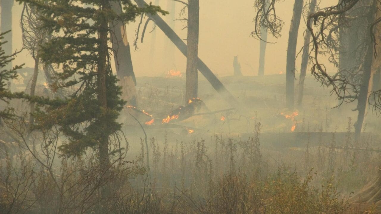
Photo by Jim Murphy
“Well,” I think to myself, “I guess this probably qualifies as a trail closure notice,” even if the Forest Service hasn’t posted one at any of the trail junctions I’ve passed.
I head back to the campsite, pack up and head back up toward Sun River Pass, roughly a mile and a half away, arriving there towards dark. As I said, I got a late start that day and didn’t cover a lot of miles in either direction. I get a few hundred yards past the pass and decide that I’m probably far enough away to safely camp rather than continue hiking in the dark, which is generally considered to be dangerous. I find a flat spot near the trail, set up my tent and try to relax and get to sleep.
I do a few Sudoku puzzles by the light of my headlamp and finally start to feel drowsy. By the time I turn off the headlamp, it’s full dark and I look out the left, i.e., south, side of my tent and the entire southwestern horizon is glowing bright orange. I think to myself, “I sure hope this is just a particularly dramatic sunset.”
No such luck. I get out of the tent, walk a little ways over to a break in the timber and see flames off in the distance. Unfortunately, having very little experience – well, actually none – observing forest fires at night, or in the daytime, for that matter, I am unable to gauge whether these are small flames fairly close by or large flames farther away. In either case, I decide, it looks as if I’m not done hiking for the day after all.
So, for the third time that day, I pack up and hit the trail. The rule against hiking at night suddenly didn’t seem as important as the rule against laying there in your tent doing nothing while a forest fire appears to be surrounding your camp. I strap on the headlamp and head south on the North Fork Trail, which runs pretty much straight north/south. The only problem with this move is that the brightest part of the fire continues to be almost due south, i.e., just a couple of compass points off of straight ahead of me. I’m still unable to judge just how far away it is, but my thinking is that I know I have fire behind me, so my only real option here is to head south as fast as I can in hopes of getting past the fire ahead of me before it burns across the trail. At that point, my only options would be to bushwhack east up a ridge in the dark – not an attractive prospect.
I remind myself that people make very poor, often fatal, decisions when they panic in what they perceive to be survival situations, so, keeping as calm as I can, I continue hiking what was the fastest three miles I’ve ever done with a backpack, I promise you. Knowing that a broken, or even badly sprained, ankle could very possibly be a death sentence, I refrained from running, but I was definitely setting a personal speed record nonetheless. I don’t carry a watch in the wilderness, so I didn’t time it, but I was moving faster than I ever did when I first started hiking the Bob twenty-five years ago.
But, after what seemed, at least an hour on the trail, the fire still looked to be an indeterminable distance away and still almost directly ahead of me. Am I going to be able to head it off and get past it before it burns across the trail and I’m trapped with fire ahead and behind? There doesn’t seem to be any other option than continuing south; either it hasn’t gotten to the trail and I’ll be able to get past it, or it will have gotten to the trail and . . . . I decide to visualize the former rather than the latter, which I’ll try to cope with if and when.
Oh, yeah. Did I mention that the wind was now blowing about 20mph from the west, i.e., from behind the fire and towards the trail? Didn’t help my anxiety level.
I remember thinking, “Hey, I could win a Darwin Award for this.” Then, “Damn, I don’t have a thing to wear to the awards ceremony . . . . No. Wait. The recipients don’t have to worry about that, do they?” I also thought about the possibility of having to head up that ridge to the east and remembered the smokejumpers that Norman Maclean wrote about in Young Men and Fire, all of them forty or forty-five years younger than me, who didn’t make it safely up the ridge. But, hey, I thought, if I do live to write about this, there’s my title, right? Old Men and Fire. Sorry, Mr. Maclean, hope you wouldn’t have minded. No, I quickly realize, that kind of levity would be pretty inappropriate, given the fate of those smokejumpers.
I also remember thinking that I would ultimately like to have my ashes scattered in the Bob Marshall Wilderness, but just maybe not tonight.
At long last, I start coming abreast of the fire, off to my right. For the next quarter mile or so, the ridgeline a few hundred yards away is lit up with sparkly little fires consistent with the main fire having burned past it. Still impossible for a novice to judge, at night, just how far away, but it’s closer than I wanted to be. That I can tell you, to quote a well-known American.
By the time I get up abreast of the intense flames (Point “F”), they appear to be two to three hundred yards away. But, again, this was an uneducated guess, and even if I’d had a tape measure with me . . . . So let’s just say they were close. I was more focused on having actually won the race and now putting as much distance between me and the fire that was finally growing fainter behind me. My little point-and-shoot camera was, of course, not designed for nighttime photography and really couldn’t do justice to what I was actually seeing.
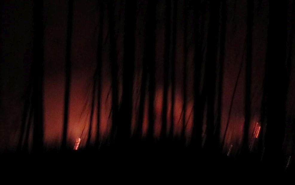
Photo by Jim Murphy
Trust me, it was a lot closer than it looks here. I continued on for another hour or so until there was just a faint glow behind me in the north, and about 3:00AM (checked the time on my camera) collapsed into the first level tentsite I could find. I’ve spent a lot of days in the wilderness that non-hikers might describe as boring and uneventful. This had not been one of those.
I got up very late the next day and continued south to the junction of trail 108, which I had briefly considered checking the previous day, ultimately deciding not to bother. Sure enough:
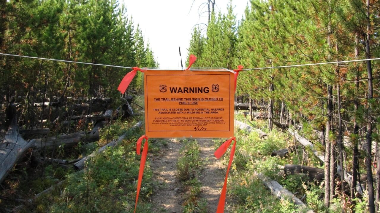
Photo by Jim Murphy
It was dated September 1, when I had been laying up all day a mile or so north, recuperating from my two days of bushwhacking through the dense timber and then climbing over a mile or two of deadfall. It should be noted that, had I not lost the trail, I would very likely have come through this spot on the 31st, possibly even the 30th, and could have very well had this very same adventure anyway. That’s what the Forest Service means when they talk about traveling at your own risk.
Well, this has run a lot longer than the 140 characters that people are used to these days, so I’ll wrap it up here rather than going on to describe: the look on the Forest Service guy’s face when he rode up out the woods and found me camped on Wrong Creek, just a little ways from the closure notice; the bowhunters that offered me a ride on one of their spare horses when they found me at the foot of the pass – the pass that the Forest Service guy said I had to get over ASAP; how the 16-year-old mare they put me on came close to laying down and dying on the way up the pass, so I ended up walking anyway; and how these bowhunters, Andy and Dustin from Ronan, bought me dinner in Choteau (my wallet was in my car) and then drove in excess of a hundred miles out of their way to drop me at my car. I sent Andy a check for the dinner and all the extra diesel he burned, and he refused to cash it. One of the things I love about spending so much time in the wilderness is that the people you meet are (almost) always at their best. These guys really lived up to that.
Andy and Dustin.
Photo by Jim Murphy
Final thoughts: In hindsight, some of the choices I made don’t look as good now as they did at the time I made them, but . . . . Woulda, Coulda, Shoulda, If, right? For one thing, it’s probably a good idea to move a little more quickly through the wilderness when there is fire anywhere in the general vicinity, especially if you’re going to be completely out of touch – and uninformed – for a week or more, as I make a point of trying to be. My mantra has always been that the point is to be in the wilderness, not to get through it, and having virtually unlimited time, I tend to dawdle at places like Dean Lake:

Dean Lake.
Photo by Jim Murphy
Needless to say, that philosophy didn’t serve me well on this trip. I wish my mental coin flip at that unmapped fork in the trail had come up the other way, but, based on my extensive hiking experience, I really thought I’d picked the correct fork. Staying with that choice to the point where I couldn’t find it any longer when I finally decided to backtrack, is, of course, entirely on me. Won’t be doing that again.
I also, it is now abundantly clear, should have done that one-mile or so hike in the opposite direction to check for a closure sign at the junction of Trail 108 at Wrong Creek, instead of relying on the presence – or absence – of closure signs at junctions on my way north. As Joe Woodhead, the Forest Service fire guy so patiently explained, once the Forest Service has closed an area, there’s no point in putting up more signs within the closure, because – Duh! – people aren’t supposed to be there to see them in the first place!!!!
Want to keep up with all that’s going on at Atlas Guides? Sign up for our newsletter!
Read more!
Check out some related blog posts!
Get our trail guide for this area!
Continental Divide Trail
Considered by many to be the most remote and challenging of the triple crown trails, the Continental Divide Trail is a 3100 mile adventure through five western states.
3100 mi (4980 km) $39.99 full guide
Colorado, Continental Divide Trail
Photo by David Getchel
Colorado, Continental Divide Trail
Photo by David Getchel
Continental Divide Trail
Considered by many to be the most remote and challenging of the triple crown trails, the Continental Divide Trail is a 3100 mile adventure through five western states.
3100 mi (4980 km)
$39.99 full guide
Get our trail guide for this area!
About the Author
Natalie McMillan
Natalie grew up hiking in Arizona where she fell in love with the outdoors. Her favorite hikes are to Havasu Falls in the Grand Canyon and Angel’s Landing in Zion National Park, UT. She loves taking pictures of people, places, and nature, which might explain why she has almost 47,000 photos currently residing on her phone. She takes care of all things related to social media and marketing and recently moved to Denver, CO from Flagstaff, AZ. You may find her frolicking around the trails and mountains of Colorado, or exploring the new city she gets to call home.
My Trail Story by Lara Handwerker
Planning an adventure? Check out our popular trail guides! 4.8 stars (17K+ ratings)
Photo provided by Lara Handwerker
My Trail Story featuring Lara Handwerker
After meeting on the Appalachian Trail, Lara and her boyfriend Mike got married and decided to hike the Continental Divide Trail for their honeymoon. And they said they wouldn't have it any other way.
Natalie McMillan My Trail Story 03/14/2019
Natalie McMillan
My Trail Story
03/14/2019
Photo by Lara Handwerker
When you hear the word “honeymoon,” you might imagine a tropical vacation, perhaps a cruise or another tranquil location with white, sandy beaches on which to relax and sip sangria. Or maybe the image that comes to mind is posh European jet setting, strolling through the streets of Paris or Munich, indulging in delicious food and soaking in the culture from countries that are not your own. Likely, abandoning your home and vehicle before setting off on a months-long journey with but one set of clothing, walking in a linear fashion from (before) sunup to (after) sundown, dealing with hunger, pain, and extreme temperatures on a daily basis, sharing just a 20 square foot space with your new spouse each night, and striding through rain, snow, lightning, and overflowing rivers until reaching a destination that was nearly 3,000 miles from where you started did not appear on that mental Pinterest board with “honeymoon” at the top.
Photo by Lara Handwerker
Photo by Lara Handwerker
Nevertheless, that is exactly the celebration of marriage that my husband Mike and I chose to partake in during the summer of 2018. Having met for the first time and beginning our relationship while both thru-hiking the Appalachian Trail in 2015, we determined that another trip along the length of the U.S. would be the perfect way for us to begin our marriage as well. So in June 2018, we moved all of our belongings into storage, left our home in Richmond, Virginia, and started a thru-hike on the Continental Divide Trail. We had hiked the AT northbound and would have likely considered doing the same for our second long trail, but we didn’t complete our Masters degrees in Richmond until late May, so heading southbound on the CDT was our only option. Looking back, we could not have chosen a better direction for this incredibly unique trail and would not have had it any other way.
We were eager to get started, and also unsure of how many miles we’d be able to complete each day since it had been three years since our last thru-hike, so we headed south from the Canadian border with a very early start date of June 15th. Montana had received about 150% of its regular snowpack that winter, so conditions were still very snowy and sketchy at times during our first week on the CDT in Glacier National Park. Like most other early-start SOBOs on the CDT, we had to start from the Chief Mountain Trailhead since the Highline Trail was far too dangerous (and closed) for us without serious winter hiking experience under our (hip)belts. Aside from that, the trail leading from Waterton Lakes to Goat Haunt was closed due to fire damage. We were a bit disappointed to not be able to hike right from Waterton, but it was still such a challenging, breathtaking, and rewarding section. Future SOBOs should truly not feel any regret whatsoever about having to take this route. We’ve never had an experience like that week before, traversing across steep snowfields with microspikes and ice axes, seeing the mountains covered in snow and lakes still frozen over, and having everywhere we went in the park entirely to ourselves—the solitude you can have in one of the most amazing places in the world via an early season thru is unparalleled.
Photo by Lara Handwerker
Photo by Lara Handwerker
It was certainly quite the start to our honeymoon—on just our second day out, it rained the entire day with temperatures in the 40s, making for a day of complete misery that culminated with us eating our dinner in the campsite privy. Not exactly the tranquil beach experience that I referenced earlier. But due to the extenuating circumstances the weather presented, we instantly had to practice our teamwork skills to stay safe and get the necessary work done—prepping dinner, getting our tent and sleep system set up without getting everything soaking wet, and securing the bear bag before settling in for the night. I look back on this day as one in particular that I’m not sure I could have gotten through on my own, but being able to work in sync with my new husband, being so uncomfortable without either of us getting short or arguing with the other—that’s an introduction to marriage that I feel so lucky to have had.
As our honeymoon hike progressed, we continued to experience such a variety of rewarding adventures and unrelenting obstacles. The CDT is truly a rollercoaster of a trail, in terms of enjoyment and trail quality. Some days, you’re navigating swollen rivers, getting lost from confusing or nonexistent directions, and climbing over or around miles of blown down trees (see: the Bob Marshall Wilderness). Then the next, you’re strolling up rolling, grassy hills where the trail is perfectly clear, there are incredible views in every single direction, and you have perfect, flat ground on which to set up your tent and watch a wildfire of a sunset streak across the sky while wondering how you got so lucky (see: the Montana/Idaho border).
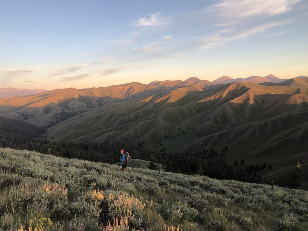
Photo by Lara Handwerker
Photo by Lara Handwerker
One of the grand things about the CDT is the variety of landscapes and ecosystems through which you travel. I’m sure most others who have hiked this path would agree that it encompasses some of the most jaw-dropping scenery you could find anywhere: Glacier National Park, the Anaconda-Pintler Wilderness, the section between Leadore, Idaho, and Lima, Montana, that in my opinion, is about the most underrated stretch of the entire trail. Yellowstone, the Tetons—if you can find a way to do them, DO THEM—and oh my breathtaking goodness, the Wind River Range. Rocky Mountain National Park, the shared experience with Colorado Trail hikers through the Collegiates, and obviously the grandeur (and imminent threat of winter) of the San Juans. The bright yellow Aspens of northern New Mexico, the freezing water and towering canyons of the Gila River, and even down to the vibrancy of the desert and the unique sense of life and beauty only found in the Bootheel. There is truly nothing else I’ve found quite like the diversity that this trail offers, and it will forever be a glimmer of awe and wonder as I dream about this part of my past.
That’s not to say we didn’t have our fair share of discomfort and injury—for me, it was almost a different injury for each section. Glacier and the Bob was a pulled Achilles, Wyoming was the shin splints from hell, and Colorado was constant nausea from altitude; New Mexico was where my body finally held up and I felt like a strong, worthy thru-hiker at last. Looking back, it’s a real shame and source of regret for me (though not something that I could have truly changed) that my various injuries prevented me from enjoying some of the most beautiful places in America quite as much as they deserved. I think that’s part of the balance beam that every thru-hiker walks: when you’re pushing your body this much, you’re not giving it a break from exhaustion and any injuries incurred, but you’re making this huge journey and accomplishing the feat of thousands of miles in just a few months. To me, that defines a conflict we experience on the long trails between two different types of enjoyment: that of lingering, of breathing deeply, of soaking it all in, and that of cramming as much as you can into one long path, of feeling how far you can push your body, of learning what your limits are and blowing right past them. And somehow, the act of thru-hiking embraces both sides of this conflict and embodies it all in one glorious package.
Photo by Lara Handwerker

Photo by Lara Handwerker
In the end, my husband and I got to travel through five states, visit countless parks, forests, and wilderness areas, share trail space with endless unique wildlife (bears! moose! badgers!), spend 24 hours a day 7 days a week (minus, you know, bathroom breaks) together for FOUR straight months, and accomplish this huge, gargantuan feat together that most people don’t even dream of in their lifetimes (disclaimer: the ability to even begin this journey was largely a product of our shared privilege, and I recognize that many people would not have the opportunity for a massive undertaking like this even if they wanted to), all in the first half-year of marriage. I can say with certainty that this unique approach to a honeymoon did nothing but make us stronger as a couple, allow us to share 3,000 hours of teamwork, deep conversation, and belly laughs, and give us a lifetime of incredible memories to look back on for the rest of our days. And truly, what tropical vacation could have brought us that?
Photo by Lara Handwerker
Photo by Lara Handwerker
Want to keep up with all that’s going on at Atlas Guides? Sign up for our newsletter!
Read more!
Check out some related blog posts!
Get our trail guide for this area!
Continental Divide Trail
Considered by many to be the most remote and challenging of the triple crown trails, the Continental Divide Trail is a 3100 mile adventure through five western states.
3100 mi (4980 km) $39.99 full guide
Colorado, Continental Divide Trail
Photo by David Getchel
Colorado, Continental Divide Trail
Photo by David Getchel
Continental Divide Trail
Considered by many to be the most remote and challenging of the triple crown trails, the Continental Divide Trail is a 3100 mile adventure through five western states.
3100 mi (4980 km)
$39.99 full guide
Get our trail guide for this area!
About the Author
Natalie McMillan
Natalie grew up hiking in Arizona where she fell in love with the outdoors. Her favorite hikes are to Havasu Falls in the Grand Canyon and Angel’s Landing in Zion National Park, UT. She loves taking pictures of people, places, and nature, which might explain why she has almost 47,000 photos currently residing on her phone. She takes care of all things related to social media and marketing and recently moved to Denver, CO from Flagstaff, AZ. You may find her frolicking around the trails and mountains of Colorado, or exploring the new city she gets to call home.
My Trail Story by Crunchmaster
Planning an adventure? Check out our popular trail guides! 4.8 stars (17K+ ratings)
Photo by Trevor Pyke
My Trail Story featuring Crunchmaster
Trevor Pyke, a.k.a. Crunchmaster, shares how he's come to love thru-hiking and what he learned hiking the Pacific Crest Trail, Appalachian Trail, and parts of the Continental Divide Trail.
Natalie McMillan My Trail Story 02/21/2019
Natalie McMillan
My Trail Story
02/21/2019
What was your trail name?
Crunchmaster
How did you get your trail name?
I got my trail name on the Appalachian Trail because I was sponsored by “Crunchmaster Crackers”. I had a friend that was a salesman for the company and they wanted to get their brand out there! They would ship me boxes of crackers and I would hand them out to other hikers.
What trail(s) did you hike?
I have hiked the Appalachian Trail, the Pacific Crest Trail twice, and about half of the Continental Divide Trail.
When did you hike?
I hiked the Appalachian Trail in 2013, the Pacific Crest Trail in 2015 and 2018, and the Continental Divide Trail sections in 2016-2017.
How old are you?
I am 24 years old.
Photo by Trevor Pyke
Photo by Trevor Pyke
What was your favorite food on the trail?
My go to food has always been fritos, summer sausage, and cheese.
What advice would you give to someone who has never done a thru-hike before?
My advice to first time thru hikers would be to never give up on a bad day. There will be days where you’re soaking wet, freezing, and feeling like you can’t go on any more. Wait until you’ve gotten to town, had a nice hot shower, and a really nice meal before making any big decisions about your hike. And most importantly, just enjoy yourself!
What does thru-hiking mean to you?
After finishing the Appalachian Trail in 2013 I knew I had become addicted. Since then, thru hiking has become my therapy and I don’t know where I would be without it. I am always the happiest when I’m on the trail.
Would you do another thru-hike? If yes, which trail is next?
Yes! I have many more trips planned for the future. I will be hiking the Pacific Crest Trail for a third time in 2019, and in 2020 I will be attempting the Great Western Loop.
What was the easiest/hardest part about your thru-hike?
Honestly, there really isn’t anything easy about hiking thousands of miles. But one of the hardest things I’ve had to deal with is the heat. I always struggle in the desert sections!
What do you miss the most?
The thing I miss the most is the freedom. You don’t have any of the stress that can haunt you in the real world. The only worries are where your next water is and what food you will eat when you get to town.
Photo by Trevor Pyke
What was your favorite feature in our app?
My favorite thing about Guthook Guides is the elevation profile. I love looking at what the trail will be like for the day! The GPS feature has also saved me from getting lost numerous times, especially on the Continental Divide Trail.
What was the one thing you had to have with you while you hiked?
My battery pack, so that I could keep my phone charged and document my trips.
Photo by Trevor Pyke
Why did you decide to go on a thru-hike in the first place?
My grandpa hiked the whole Appalachian Trail over a 12 year period and I was able to join him for about 500 miles. When he finished I knew I wanted to do the entire trail in one trip.
Did you hike solo or with other people?
I usually start out solo, but then end up meeting up with others early on in the hike.
What part of the trail was your most/least favorite?
My favorite sections of trail have been the Sierras, Northern Washington, Glacier National Park, and Maine. My least favorite parts have been pretty much all of New Mexico, the Mojave section, and New York.
How many pairs of shoes did you go through?
I typically go through 2-3 pairs of shoes on each thru hike.
Was there a highlight of your hike?
Having a big grizzly bear come through camp on my first night in Glacier National Park. And seeing 14 bears in one day in Shenandoah National Park.
What was the scariest part of your hike?
Getting stalked by a mountain lion while night hiking in Central Oregon.
Did you ever reach a point where you wanted to quit? How did you stay motivated to finish?
Many times. This is a normal feeling for anyone attempting such a big hike. Whenever I felt close to quitting I would make a phone call home to family and then get to town and get a hotel room. After taking a day off I have always been ready to keep going.
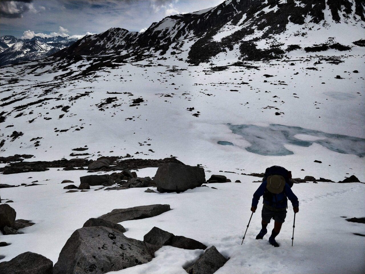
Photo by Trevor Pyke
Want to keep up with all that’s going on at Atlas Guides? Sign up for our newsletter!
Read more!
Check out some related blog posts!
Get our trail guide for this area!
Pacific Crest Trail
The Pacific Crest Trail is an epic journey of three states and over 2600 miles. Its path travels from the US border with Mexico to the northern border with Canada.
2650 mi (4260 km) $29.99 full guide
Washington, Pacific Crest Trail
Photo by Justin Helmkamp
Washington, Pacific Crest Trail
Photo by Justin Helmkamp
Pacific Crest Trail
The Pacific Crest Trail is an epic journey of three states and over 2600 miles. Its path travels from the US border with Mexico to the northern border with Canada.
2650 mi (4260 km)
$29.99 full guide
Get our trail guide for this area!
About the Author
Natalie McMillan
Natalie grew up hiking in Arizona where she fell in love with the outdoors. Her favorite hikes are to Havasu Falls in the Grand Canyon and Angel’s Landing in Zion National Park, UT. She loves taking pictures of people, places, and nature, which might explain why she has almost 47,000 photos currently residing on her phone. She takes care of all things related to social media and marketing and recently moved to Denver, CO from Flagstaff, AZ. You may find her frolicking around the trails and mountains of Colorado, or exploring the new city she gets to call home.