Explore New Alternate Trails in the Gila Wilderness
Planning an adventure? Check out our popular trail guides! 4.8 stars (17K+ ratings)
Explore New Alternate Trails in the Gila Wilderness
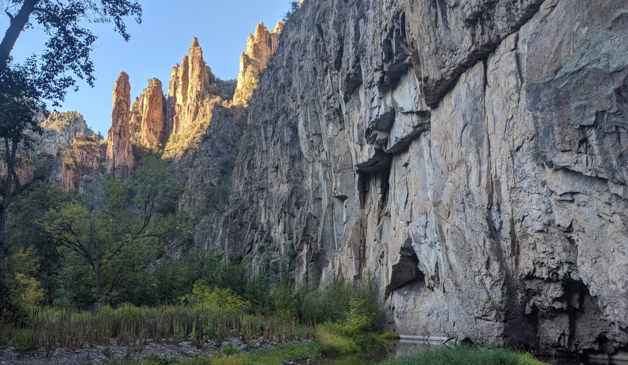
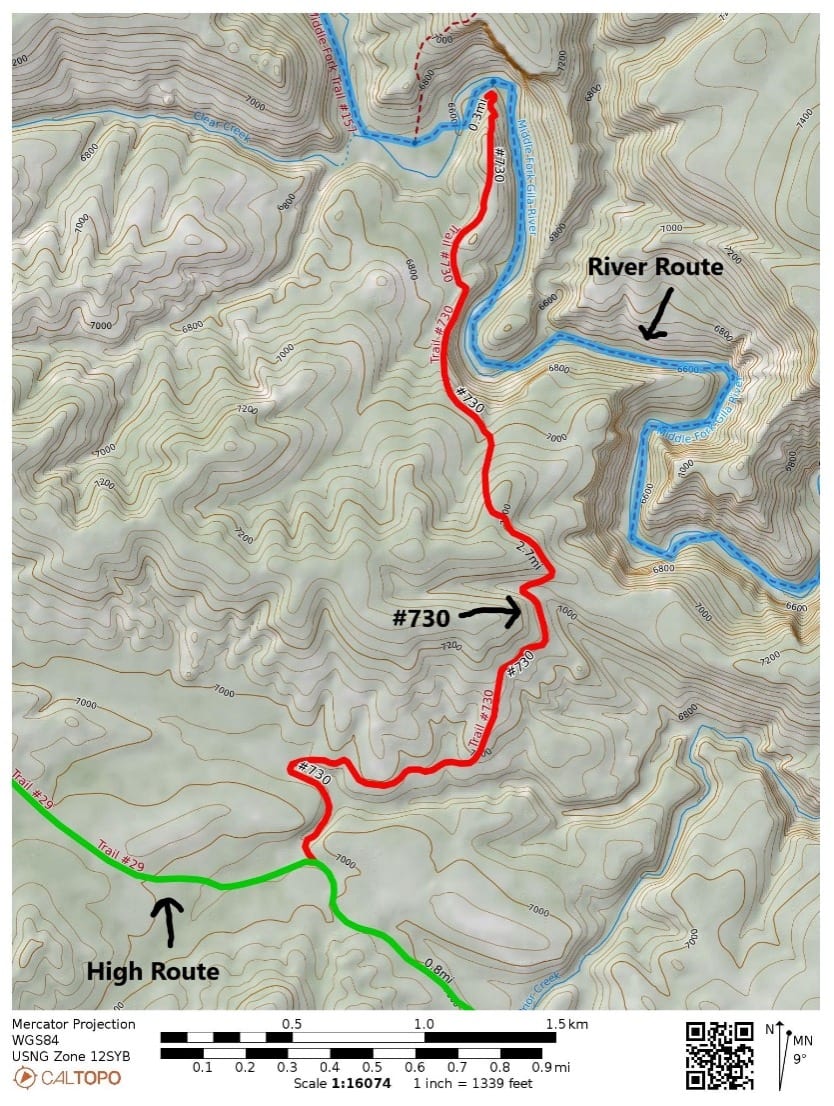
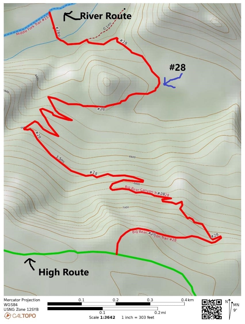
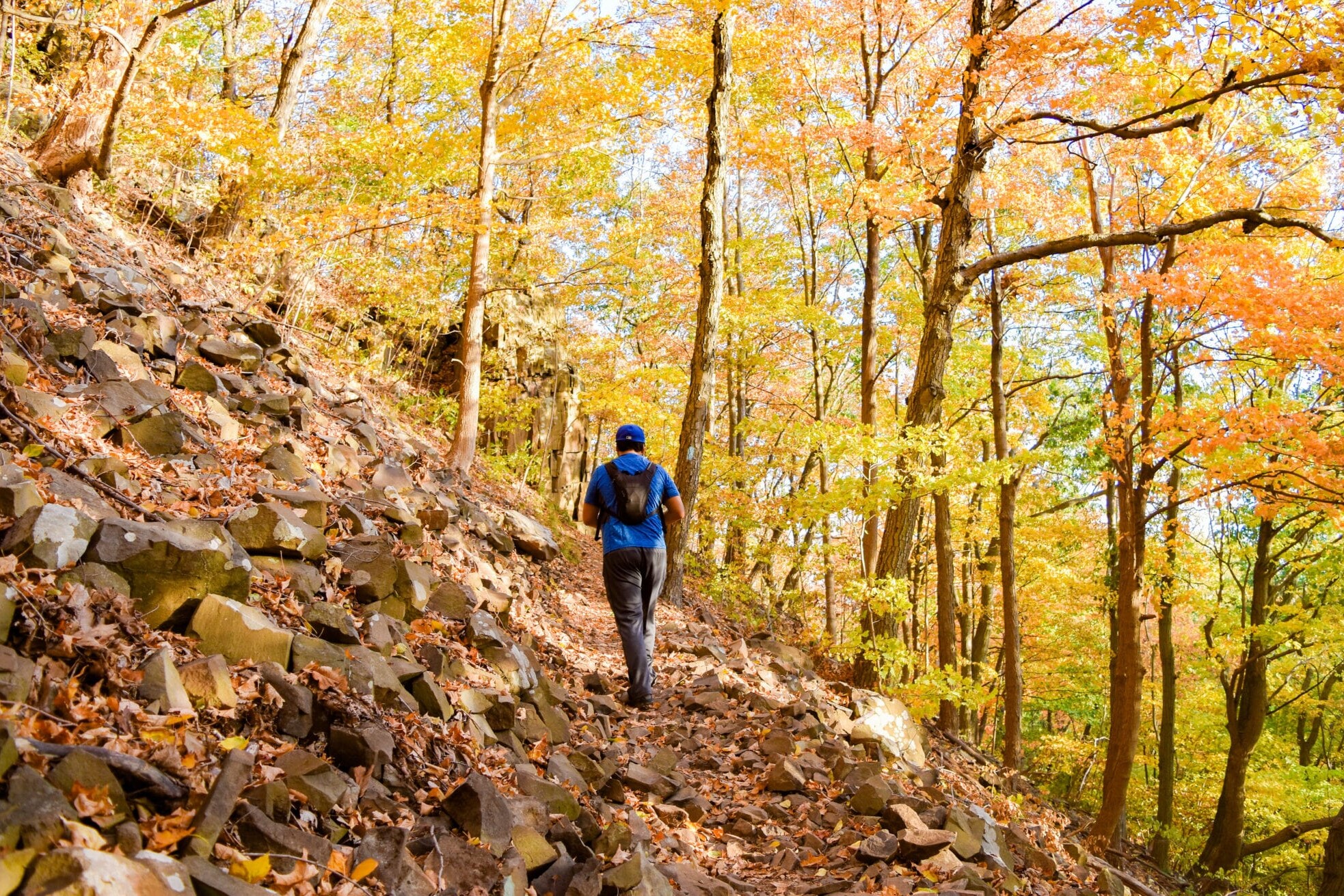
Until now, the CDT alternate in the Gila Wilderness has had two trail options: the “river route” and the “high route.” Now CDTC is adding two more trails to the Gila Wilderness alternates. They improve safety and reduce overuse. The two new trails connect the river route to the high route. One is #28, the Big Bear Trail, and the other is #730, the Coop Mesa/ Garcia Springs Trail.
Melissa Green Trail Information 04/18/2021
Melissa Green
Trail Information
04/18/2021
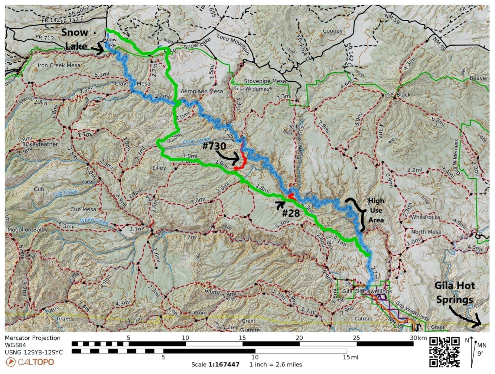
Green highlight:Gila high route, Blue highlight: Gila river route and Red Highlights: new connector trails #730 and #28.
Why add more trails?
1. It improves safety: If you are on the 30 + mile river trail that is slow traveling because of all the river crossing and then the weather changes to very cold or the river starts flooding, you may want a way to escape the river bottom. (These are both common occurrences during the dates that CDT through-hikers travel the Gila Wilderness). Alternately, if you run out of water during a dry year on the high route, you may want to take one of these trails down to the river route.
2. It disperses use: A well dispersed trail system prevents overuse issues and damage to the natural resources. The connector trails provide an option to avoid high use and/or overused areas. The most heavily used area in the Gila Wilderness is the Little Bear trail #729 to Jordan Warm Springs on the Middle Fork (see map above). This is a part of the CDT river route and a part of a popular backpacking loop. You can avoid this section by starting on the CDT high route and then using one of the connector trails to hike down to the river upstream of Jordan Warm Springs. Taking this route helps protect the area and maintain the resource for sustainable shared use.
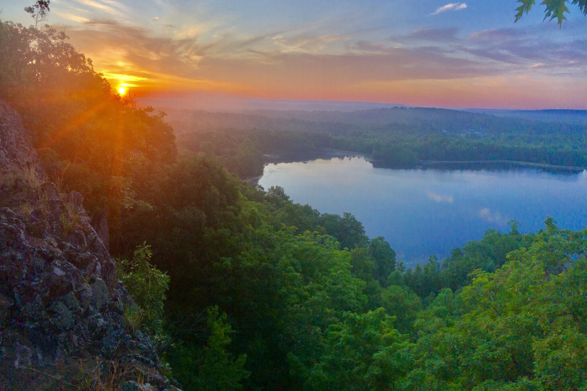
Worried about missing out if you bypass this section? The high use trail to Jordan Warm Springs is not necessarily the most beautiful. In terms of beauty and grandeur, my favorite section of the Middle Fork is between the Meadows (Middle Fork Trail junction with #28) and the Middle Fork Trail junction with Coop Mesa / Garcia Springs Trail #730. (On the map above, it is between the 2 red connector trails).
“But I miss the warm springs” – Warm springs are a treat but this area has multiple hot springs. There are privately owned hot springs at the Gila Hot Springs Campground in the resupply town of Gila Hot Springs. They are CDT-hiker friendly, with clean pools and a well-kept campground. There are adequate facilities to accommodate the use without doing damage to the natural environment. This contrasts with the steep canyon walls at Jordan Warm Springs and inexperienced campers that cause excess feces and trash in the river corridor. So, I would recommend stopping at the private hot springs during your resupply and skipping the Jordan Warm Springs.
About the connector trails:
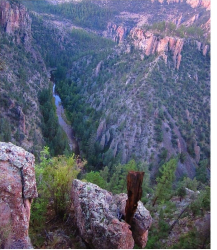
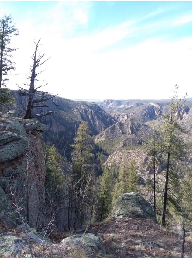
A connector trail could sound like it is unimpressive and just getting you from one place to another. However, these trails offer beautiful views and are worth hiking just to see the terrain they travel through.
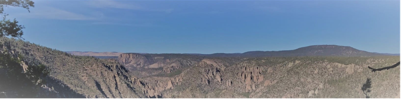
Photo by Melissa Green
Understanding the Gila
I worked on the Forest Service Gila Wilderness trail crew for over a decade. When funding disappeared, I helped create a trails program, which organizes volunteer trail projects and provides trail information in the Gila. I work with Gila Back Country Horsemen who have been doing volunteer trail work for over 17 years.
The trail projects, which benefit all trail users, and Gila Trails Info website aim to disperse trail use and to increase user safety and enjoyment of the Gila. There are so many places in the Gila that are beautiful and have water. There is no reason to over stress one area.
We organize a trail projects with the CDTC in the Gila Wilderness. Check out this year’s project in March on the CDTC website. To receive info on other Gila volunteer trail projects or plan a trip in the Gila – Check out gilatrailsinfo.org.
Read more!
Check out some related blog posts!

Get our trail guide for this area!
Continental Divide Trail
Considered by many to be the most remote and challenging of the triple crown trails, the Continental Divide Trail is a 3100 mile adventure through five western states.
3100 mi (4980 km) $39.99 full guide
Colorado, Continental Divide Trail
Photo by David Getchel
Colorado, Continental Divide Trail
Photo by David Getchel
Continental Divide Trail
Considered by many to be the most remote and challenging of the triple crown trails, the Continental Divide Trail is a 3100 mile adventure through five western states.
3100 mi (4980 km)
$39.99 full guide
Get our trail guide for this area!
About the Author

Melissa Green
Melissa Green has spent many years in the Gila Wilderness including working on the Forest Service Wilderness Trail Crew for a decade. She now leads volunteer trail projects for the Gila Back Country Horsemen in the Gila Region. She has spent much of the past 20 years working in the outdoor industry including leading 3-week backpacking trips for at-risk-youth in Oregon. In her free time, she does trail work in the Gila Wilderness, hikes and runs, works in her garden and does building projects. She is passionate about the Gila Trails and keeping them open for people to find rejuvenation in nature. To this end, she created the Gila Trails Info website which provides updated trail information for visitors and locals.
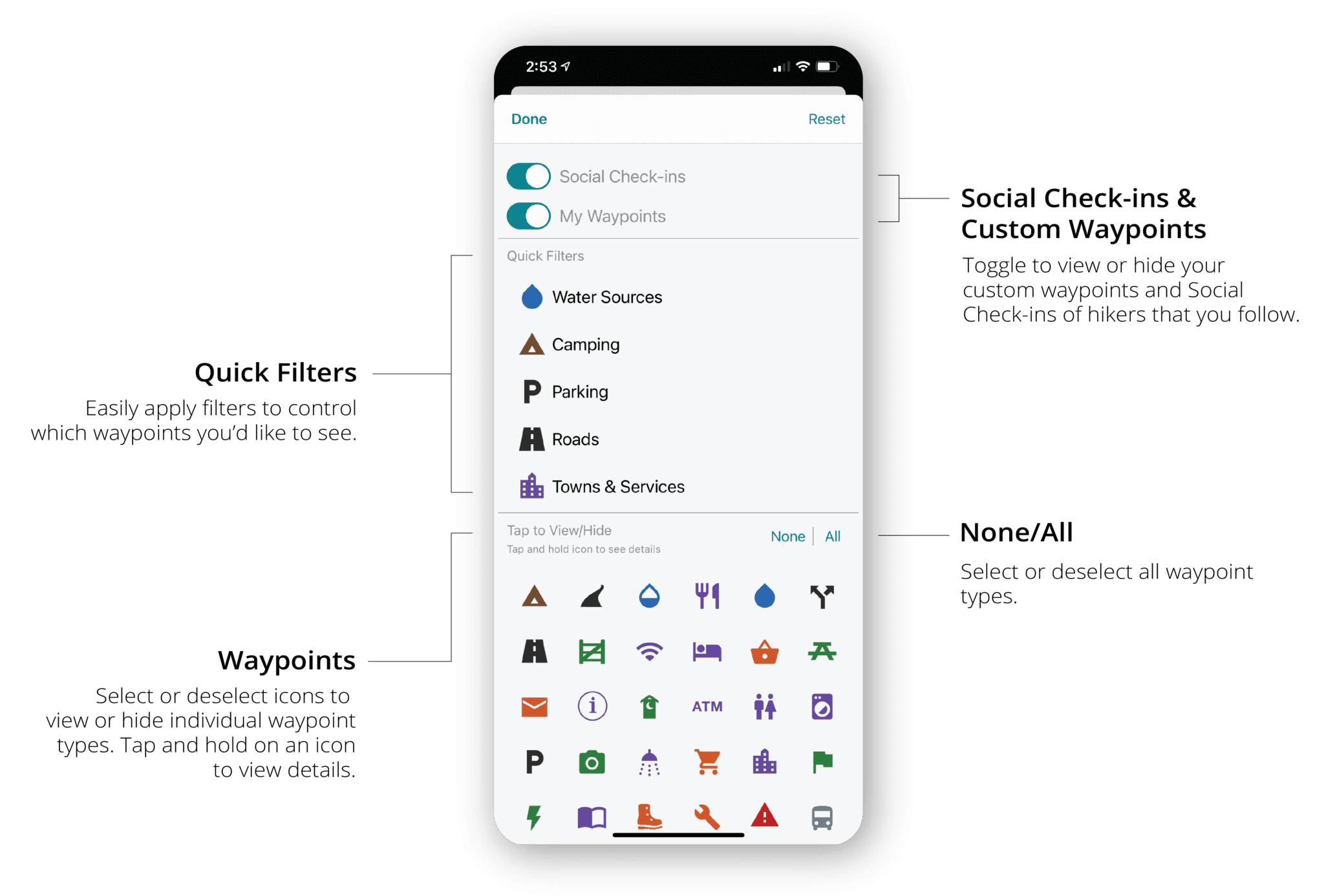
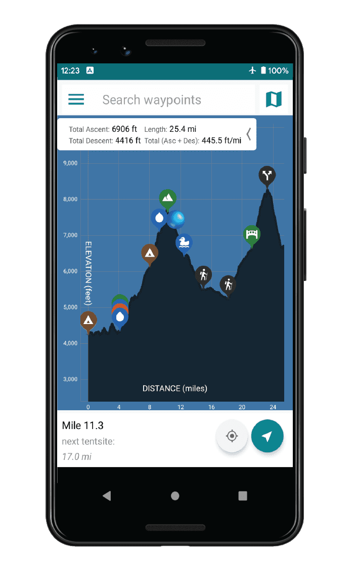
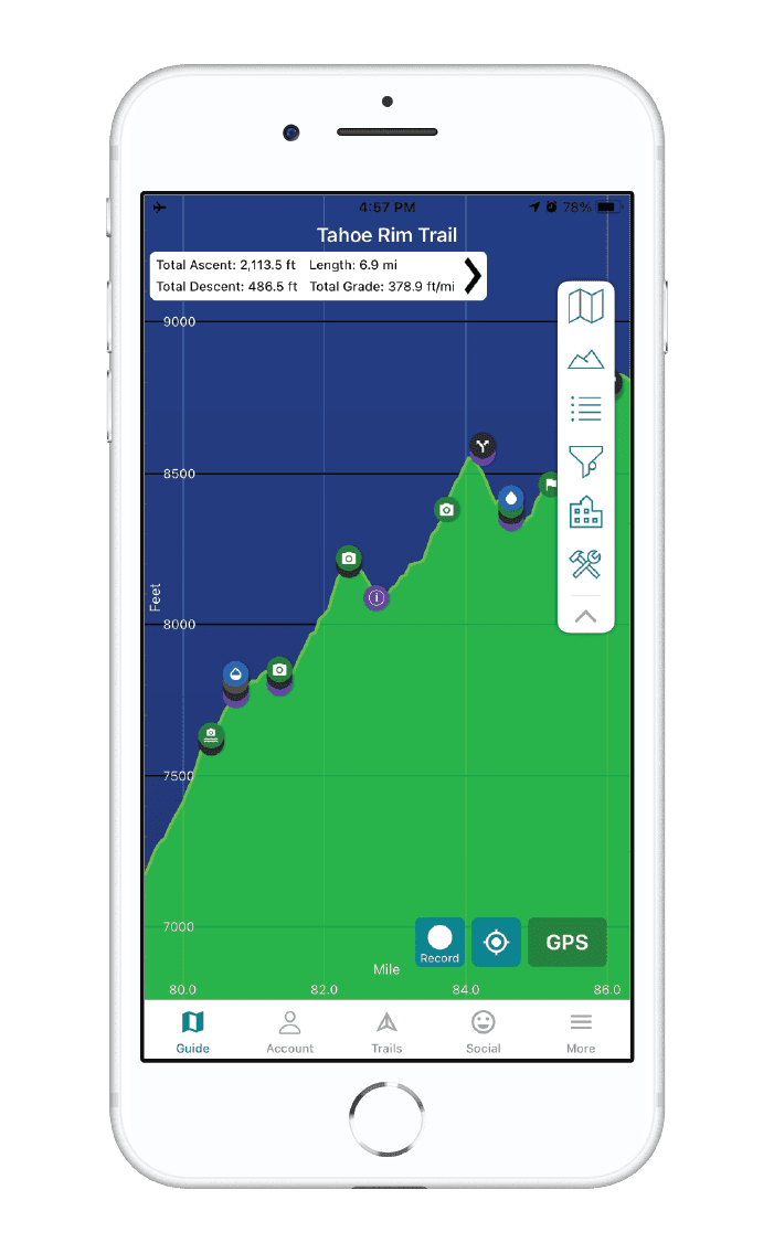
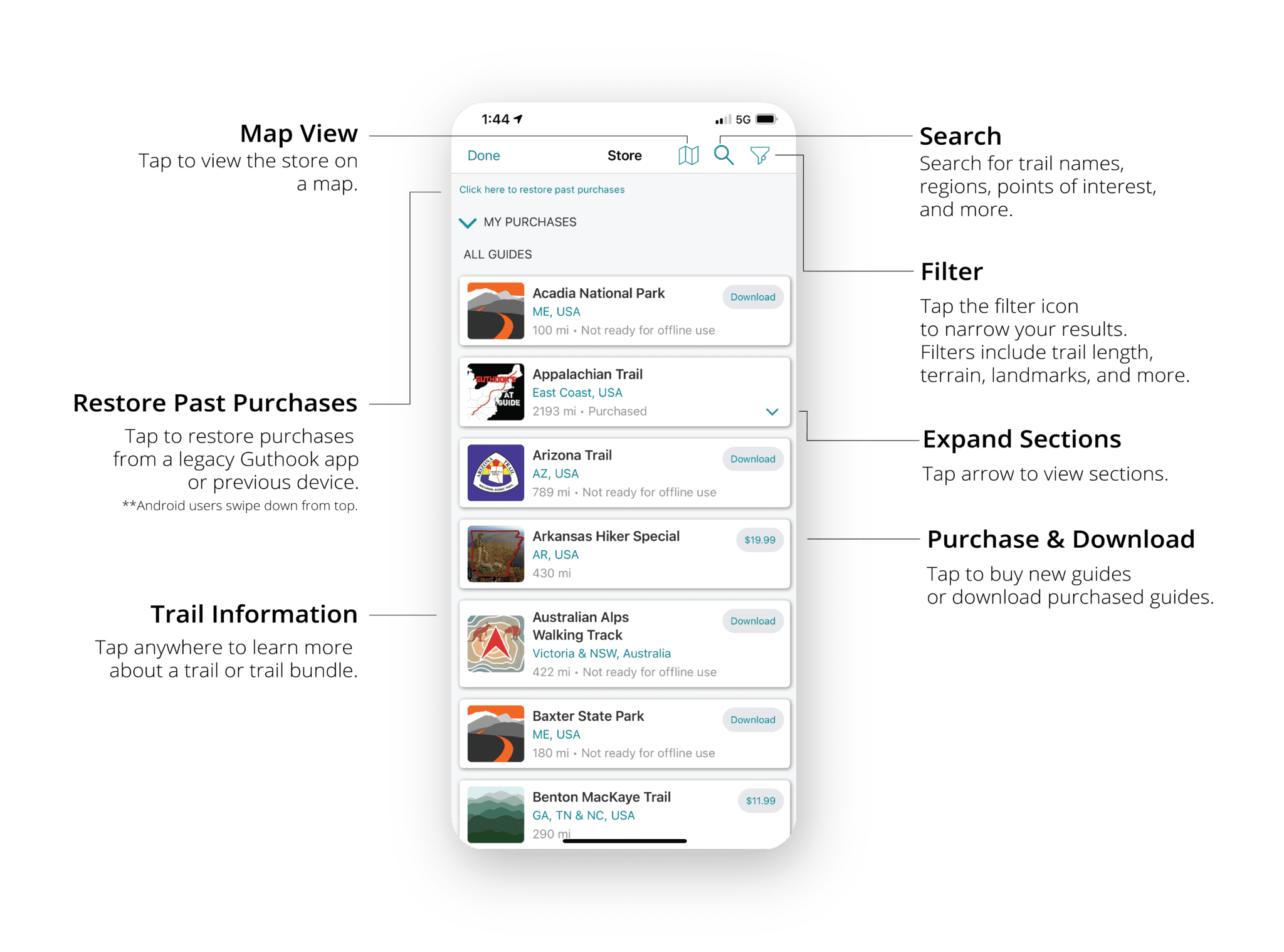
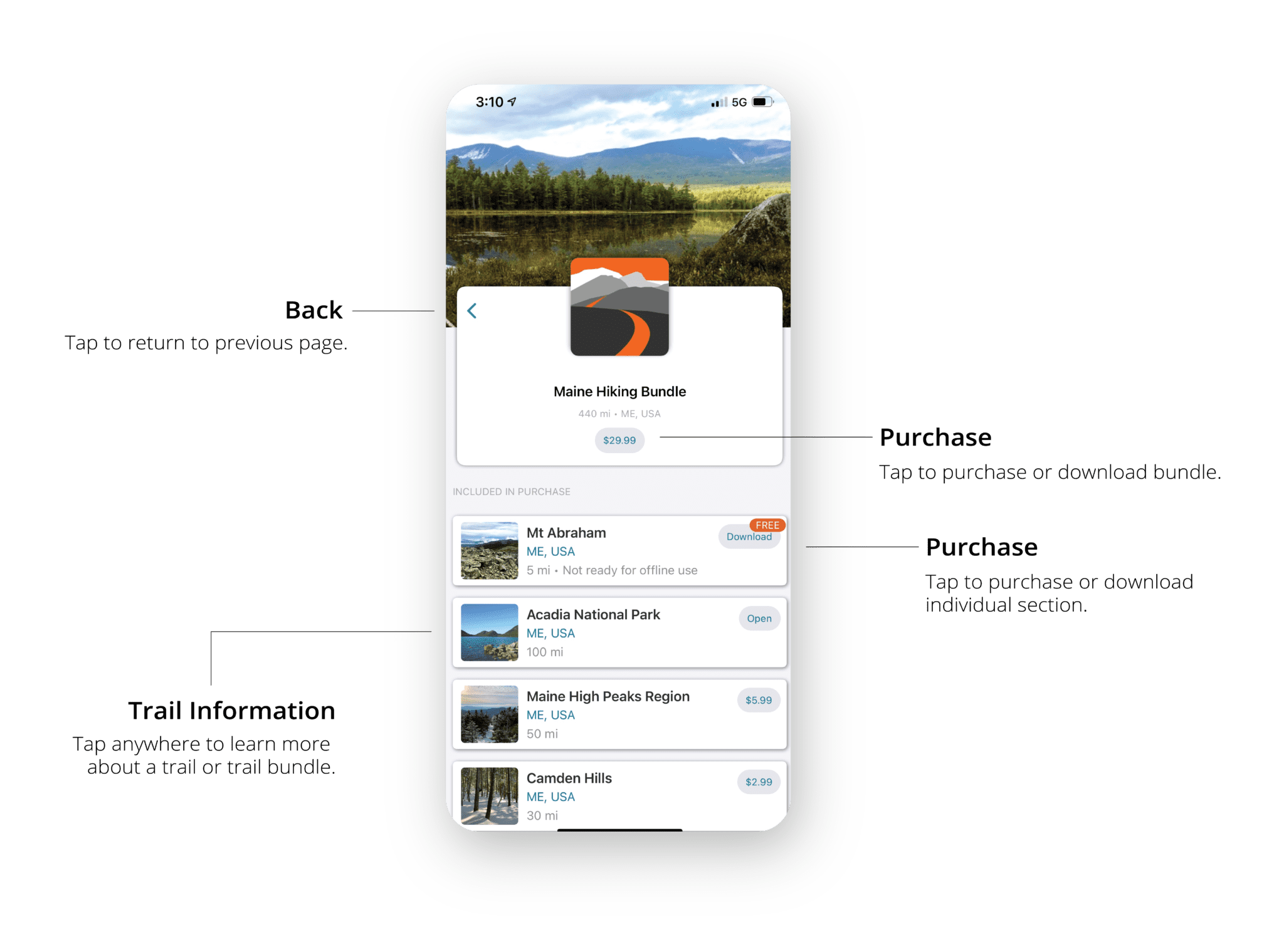
iOS: User Interface Update
iOS User Interface Update
We redesigned the tab bar and control panel in our iOS app for easier access to your purchased guides, social features, and other tools.
Tab Bar
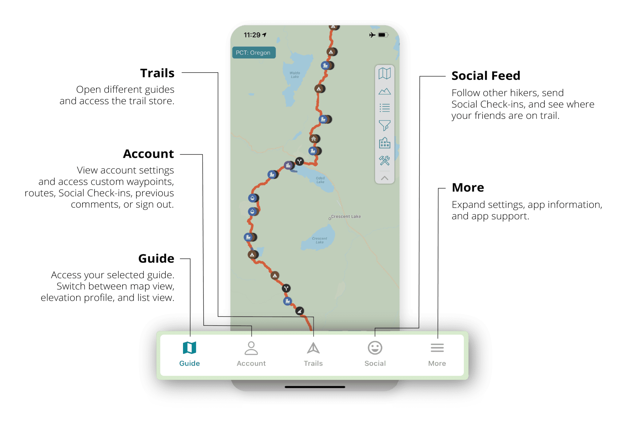
Control Panel
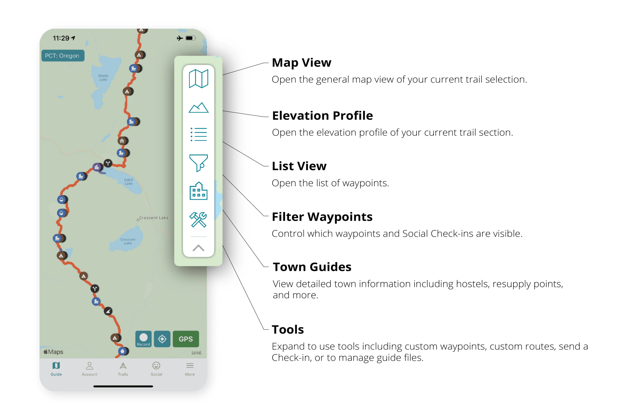
Waypoint Filters
HAVE QUESTIONS?
Email us: support@atlasguides.com

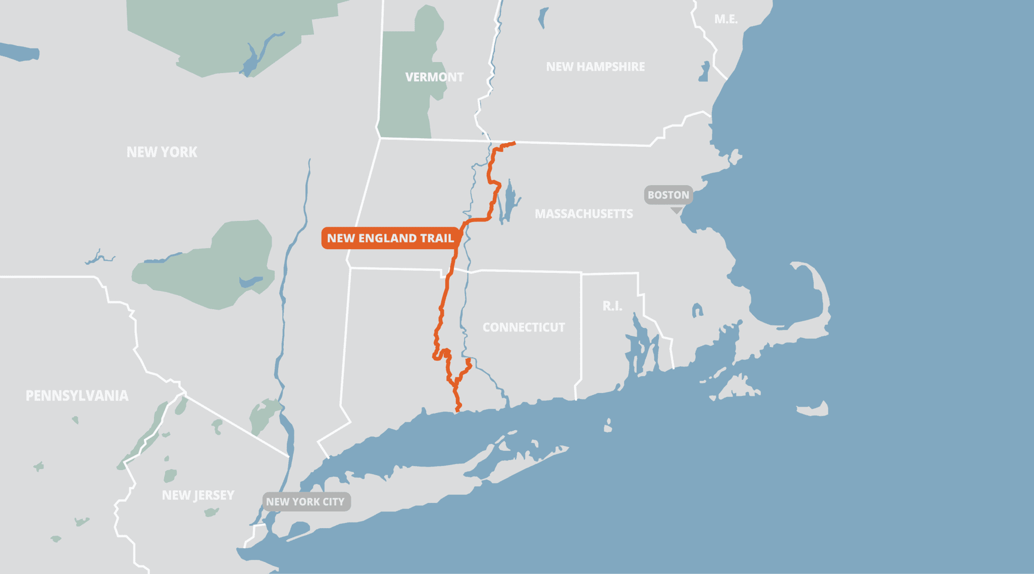
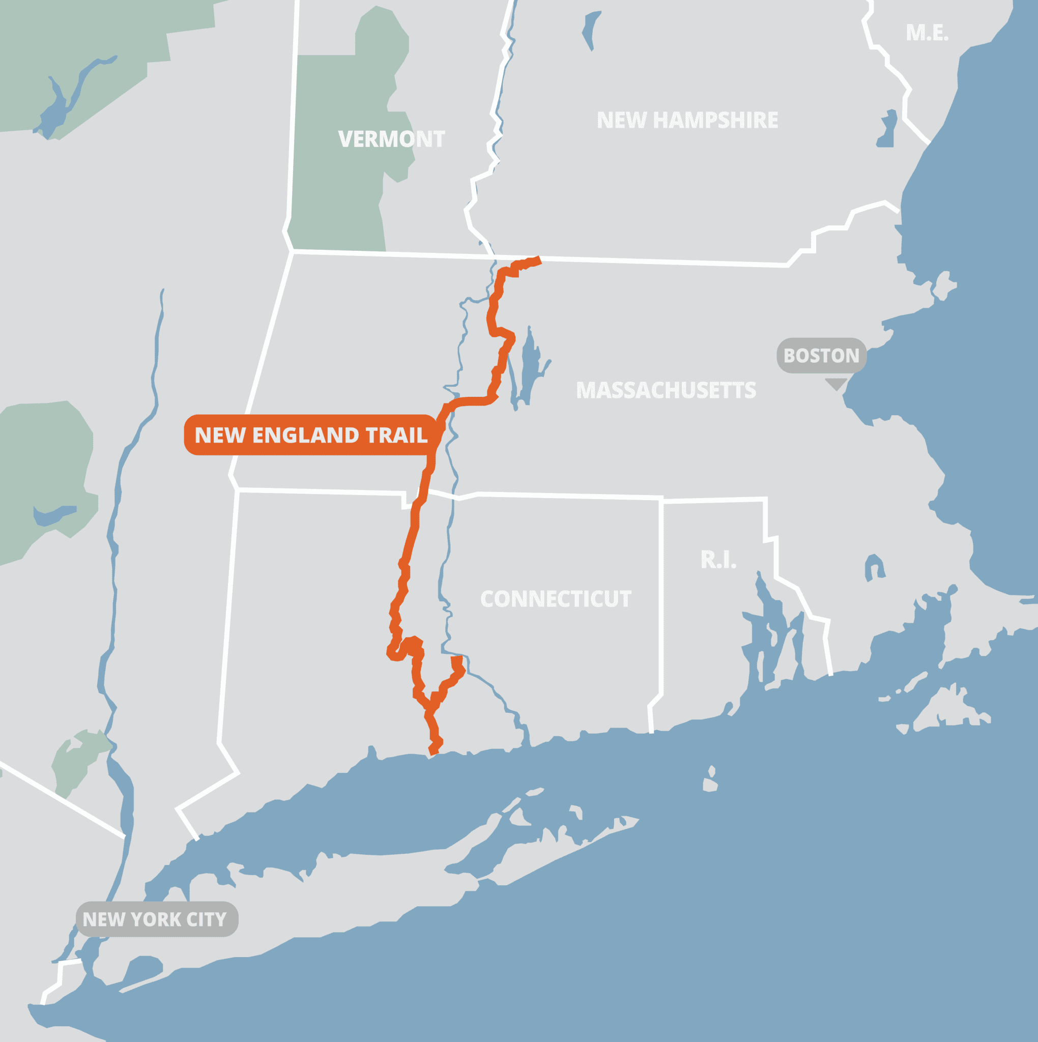
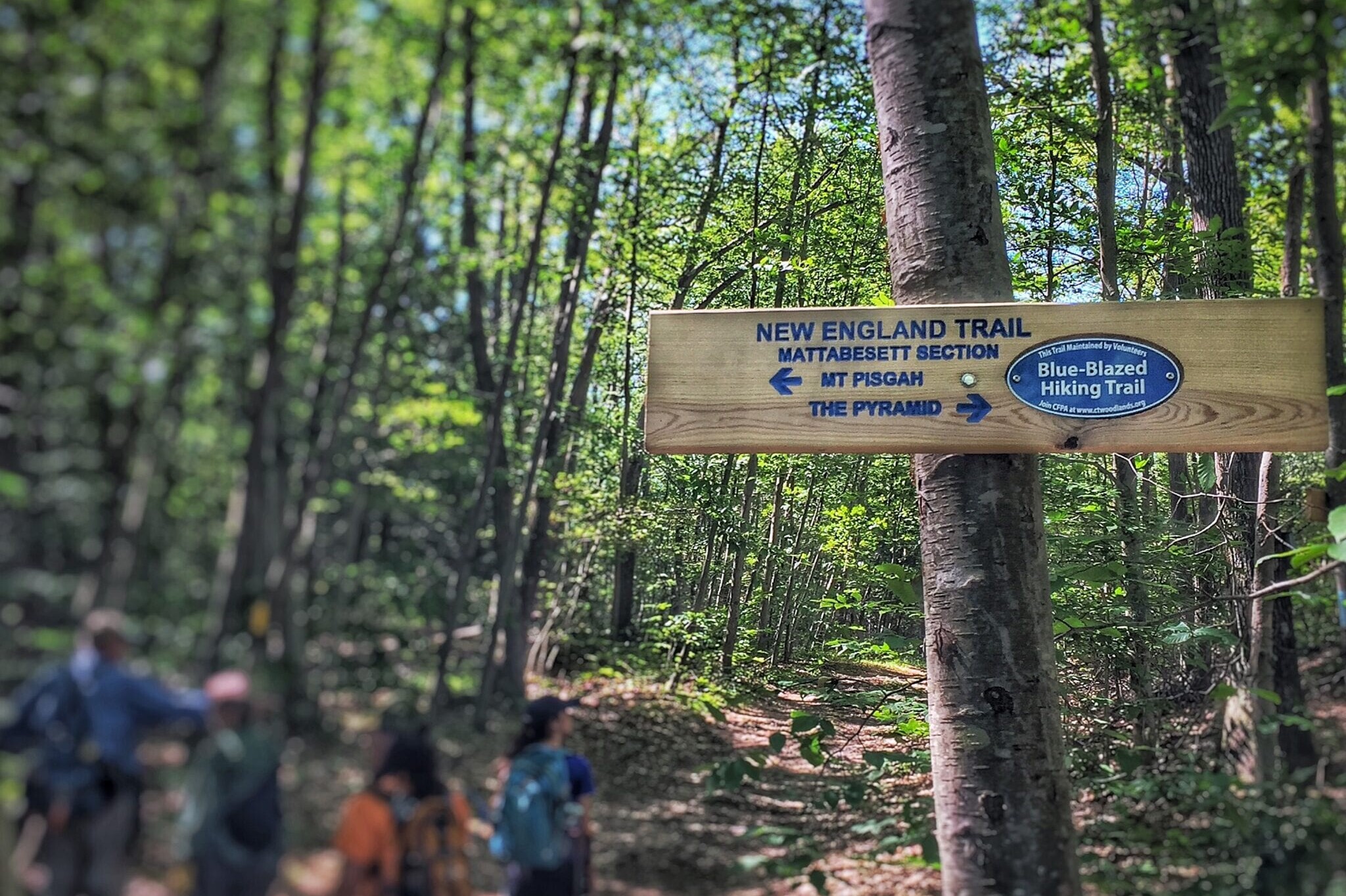
New England Trail

4.8 ★★★★★ | 17K+ Reviews
New England Trail
215 miles • Connecticut & Massachusetts, U.S.
Download our guide to access this 215 mile long New England Trail! The New England National Scenic Trail (NET) is a 215-mile hiking trail route that has been in existence for over half a century. The NET travels through 41 communities in Connecticut and Massachusetts and is comprised primarily of the historic Mattabesett, Metacomet, and Monadnock (M-M-M) Trail systems.The NET travels through classic New England landscape features - long-distance vistas with rural towns as a backdrop, agrarian lands, unfragmented forests, and large river valleys. The trail also travels through colonial historical landmarks and highlights a range of diverse ecosystems and natural resources: mountain ridges and summits, forested glades, wetlands and vernal pools, lakes, streams, and waterfalls.
$14.99 full guide
215 miles
$14.99 full guide


New England Trail Map


How can I get it?
The New England Trail map is available as an in-app purchase in our Guthook Guides app, a free download from the Apple App Store or the Google Play Store.
Our iOS and Android apps do differ slightly in their appearance. However, the majority of their features remain the same, and they access the same trail guide data.
The New England Trail is a 215-mile trail through Connecticut and Massachusetts.
$14.99
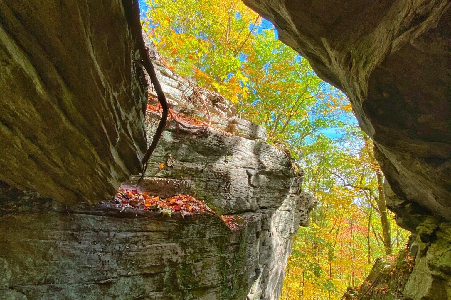
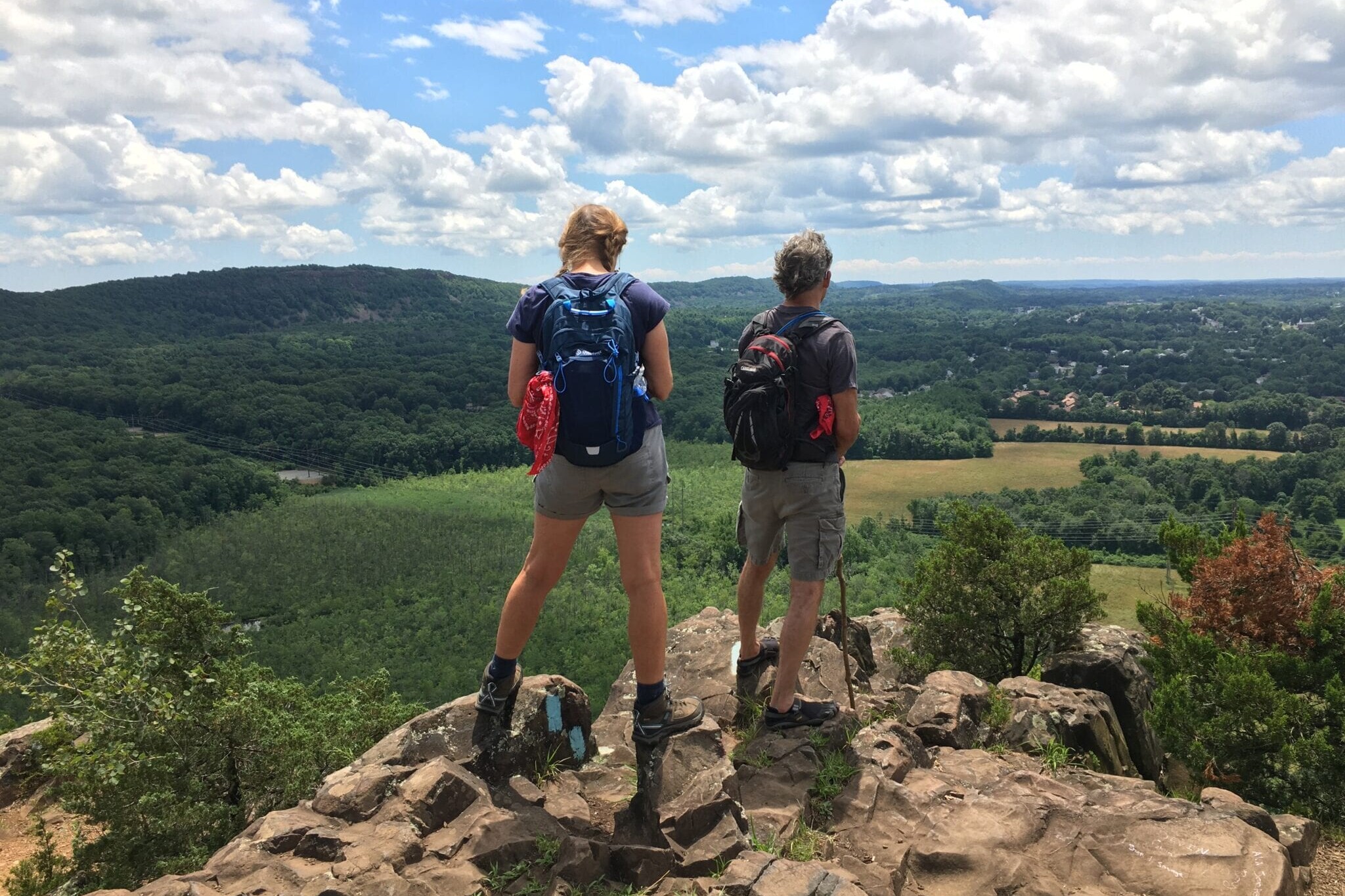
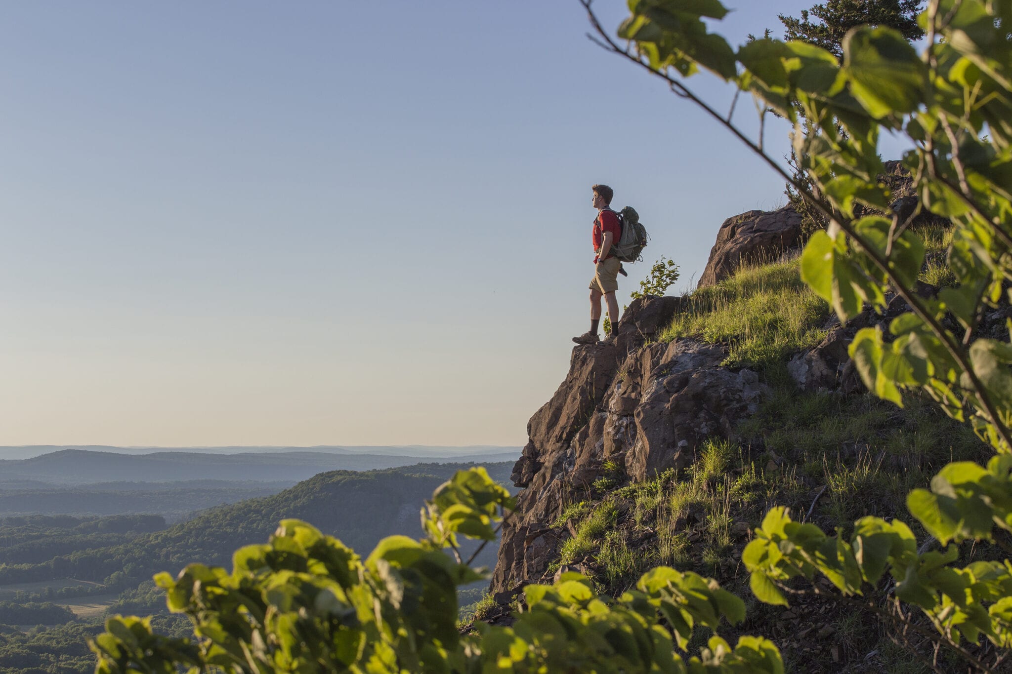
Photos of the New England Trail
Hike more.
Check out some of the other trail guides we offer!
About our partners
The New England Trail
The New England Trail guide is maintained through a partnership with Connecticut Forest & Park Association, Appalachian Mountain Club, National Park Service, and Atlas Guides.
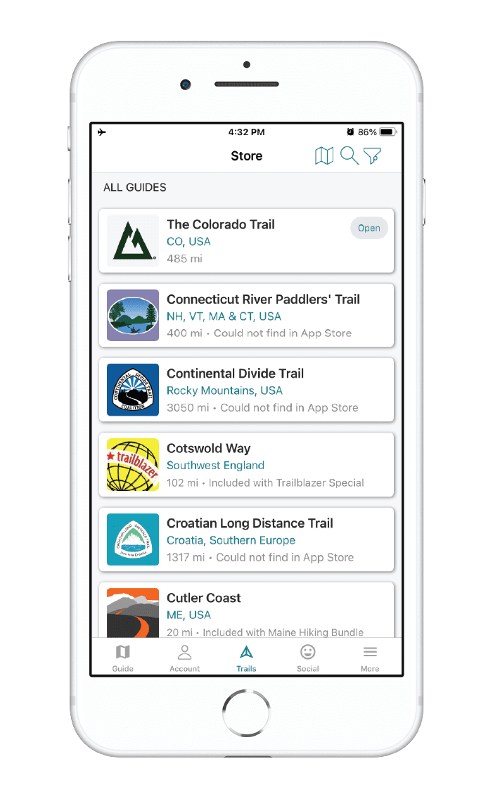
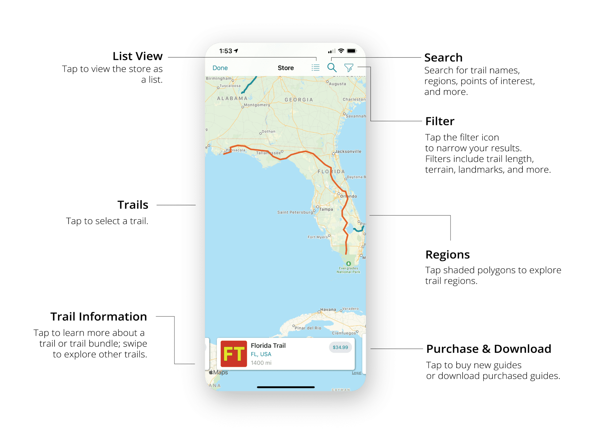
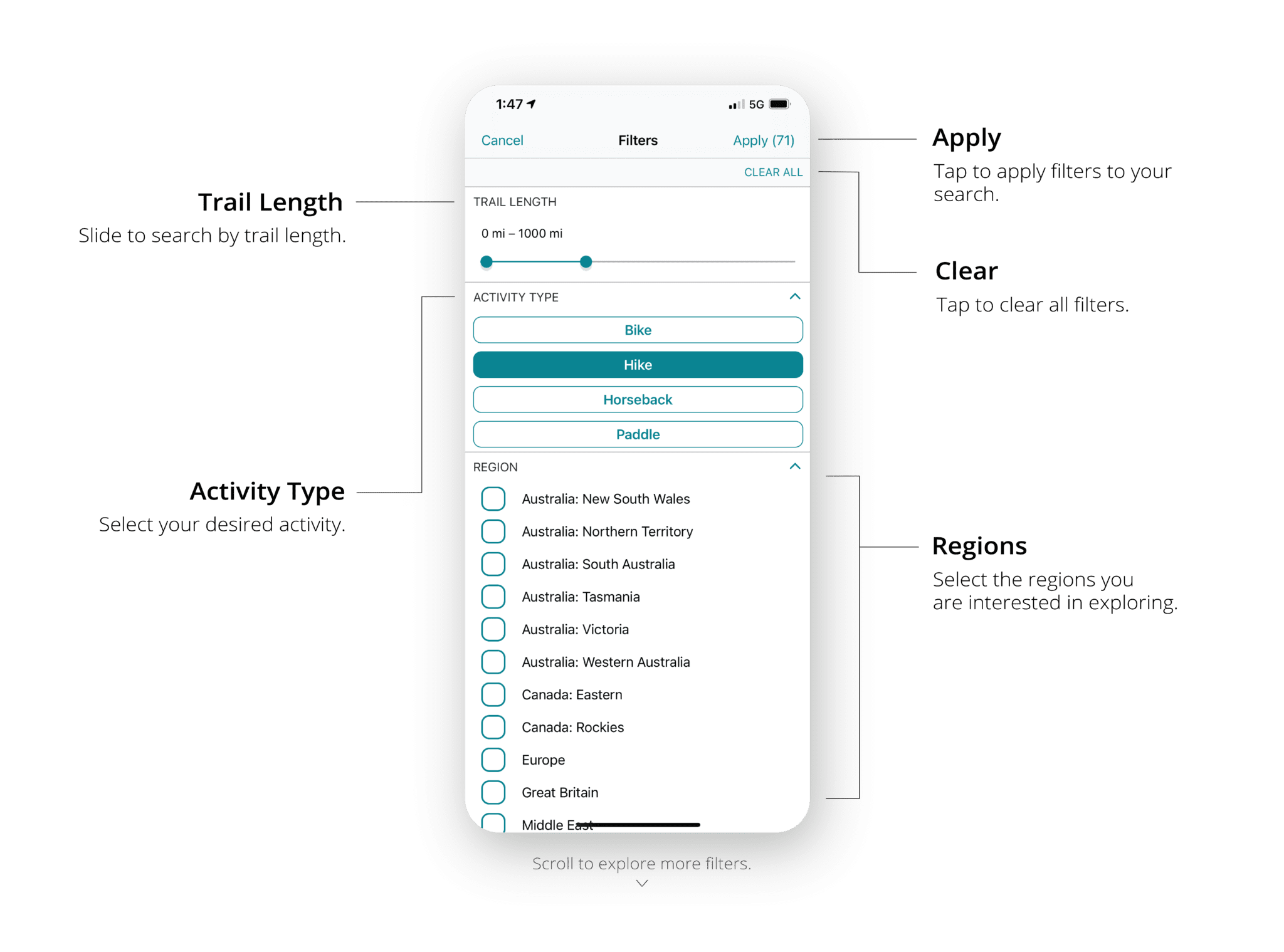
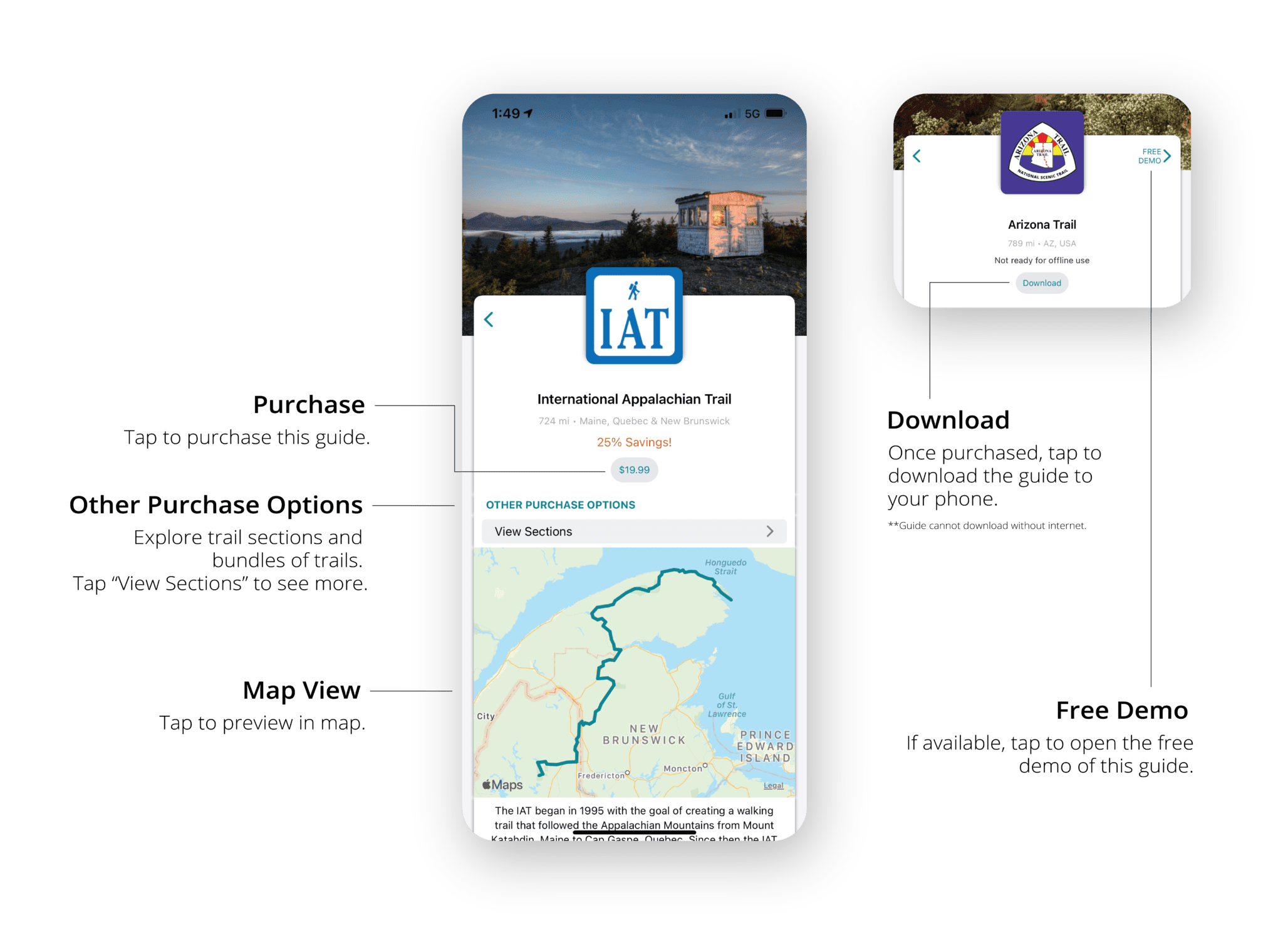
iOS and Android: New Trail Store Update
Guthook Guides Trail Store: Completely Redesigned
We redesigned our trail store in our latest Guthook Guides app update. Learn about all of the new features and explore our trails with ease.
Download or Update your Guthook Guides app:
HAVE QUESTIONS?
Email us: support@atlasguides.com

Does the Diameter of Your Cooking Pot Matter?
Planning an adventure? Check out our popular trail guides! 4.8 stars (17K+ ratings)
Does the Diameter of Your Cooking Pot Matter?
We tested the difference between five different diameter pots to see if one size results in more fuel consumption than another. This is what we learned...
Paul Bodnar Educational 1/11/2021
Paul Bodnar
Educational
1/11/2021
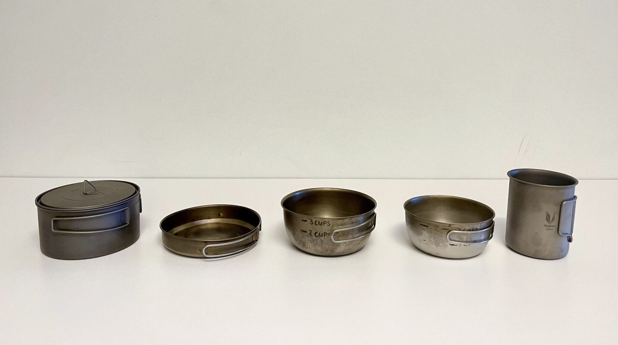
We tested 5 different diameter pots.
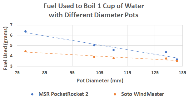
To see if the diameter of titanium pots make a difference in fuel consumption, we tested five different diameter pots varying from 78 mm (3.1 inches) to 133 mm (5.2 inches). We calculated the amount of fuel consumed to boil 1 cup of water using the MSR PocketRocket 2 and the Soto WindMaster. We tested each pot three times for each stove tested and then averaged the result.
Larger diameter pots performed better in every test.
We were surprised to learn that the larger diameter pots performed better than the narrower pots for both stoves tested. The MSR PocketRocket 2 was 43% more fuel efficient with the wider (133 mm) pot than the narrow (78 mm) pot. The Soto WindMaster, however, was only 21% more fuel efficient with the wider pot than the narrow pot.
Why do larger pots perform so much better?
We noticed the sides of the small (78mm/3.1-inch) diameter pot became much hotter than the larger diameter pots after each boil. This suggests that the flame from the stove is warming up the sides of the pot instead of the bottom of the pot (where the greatest area of water is). The picture below shows the flame wrapping around the smaller pot when using the Pocket Rocket 2. The less efficient Pocket Rocket 2 becomes more efficient as the larger diameter pot captures more of the heat.
Summary
- Larger diameter pots result in less fuel consumption than smaller diameter pots.
- A less fuel-efficient stove can be made more efficient by using a larger diameter pot.

The blue flame remains under the larger pot.
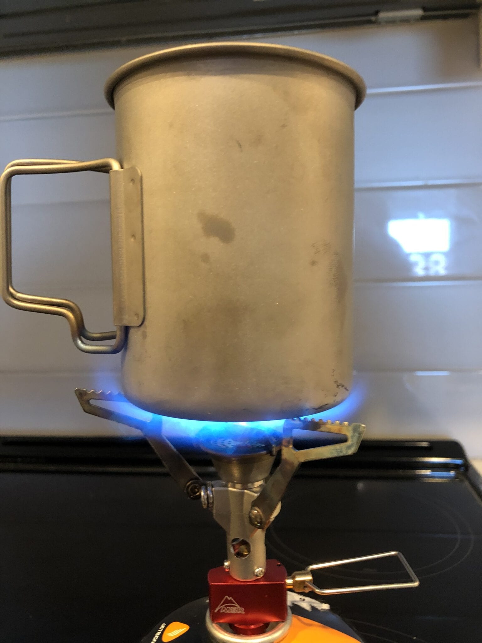
The blue flame wraps around the side of the smaller pot.
Read more!
Check out some related blog posts!

Download our popular hiking and biking guides!

Trail guides that get you to places you’ve dreamed of.
As the makers of Guthook Guides, Bikepacking Guides, and Cyclewayz, we help you navigate the most popular trails around the world on your smartphone. Our hiking guides and biking guides work completely offline. Let Guthook guide your next adventure!
Showers Lake Vista, Tahoe Rim Trail
Photo courtesy of the Tahoe Rim Trail Association

Showers Lake Vista, Tahoe Rim Trail
Photo courtesy of the Tahoe Rim Trail Association
Trail guides that get you to places you’ve dreamed of.
As the makers of Guthook Guides, Bikepacking Guides, and Cyclewayz, we help you navigate the most popular trails around the world on your smartphone. Our hiking guides and biking guides work completely offline. Let Guthook guide your next adventure!
Download our popular hiking and biking guides!
About the Author

Paul Bodnar
Paul has always liked hiking and thru-hiked the Pacific Crest Trail in 1997 after college. After years of working in chemistry, he wanted to create a career involving the outdoors, so he hiked the PCT again in 2010 to do research for his guide book, Pocket PCT. He realized that creating a smartphone app for navigating the outdoors would make it easier to keep the data current and provide a better way to navigate. While hiking with Ryan (aka Guthook) in 2010, they decided to work together to create the first comprehensive smartphone guide for the PCT.
Should I disconnect my stove or keep it connected to the canister?
Planning an adventure? Check out our popular trail guides! 4.8 stars (17K+ ratings)
Should I disconnect my stove or keep it connected to the canister?
I always wondered whether I should leave my stove connected to my fuel canister or if it was better to take it off. Here's what I found...
Paul Bodnar Educational 1/12/2021
Paul Bodnar
Educational
1/12/2021
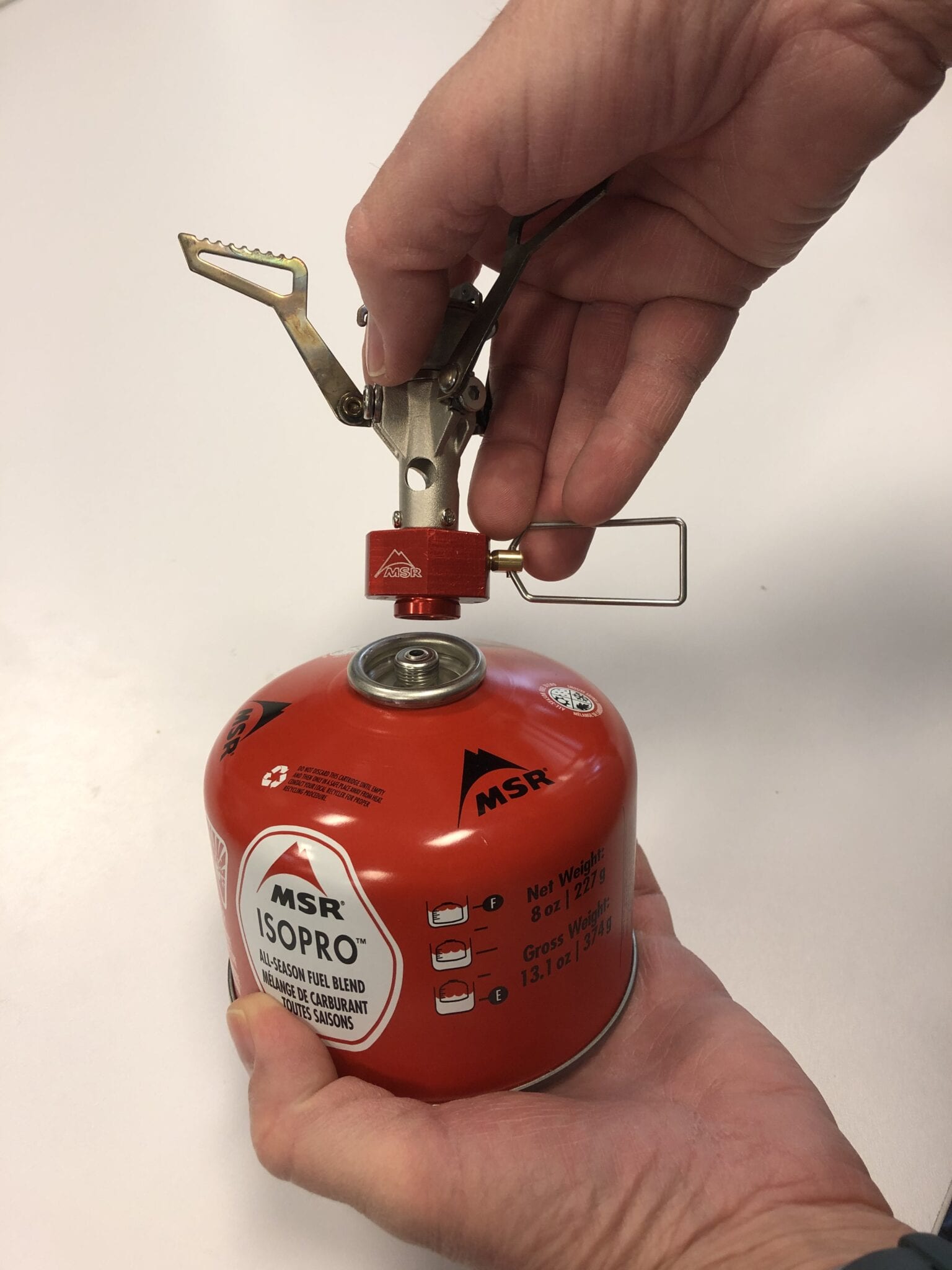
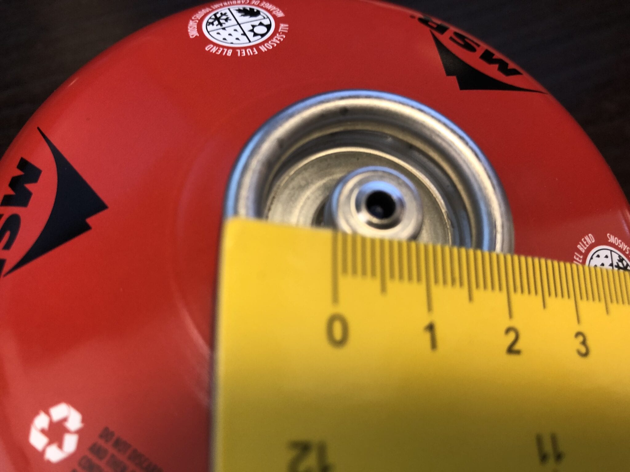
Every time I connect and disconnect my stove it sounds like I am wasting a lot of fuel –I have always wondered exactly how much fuel is lost in this transition.
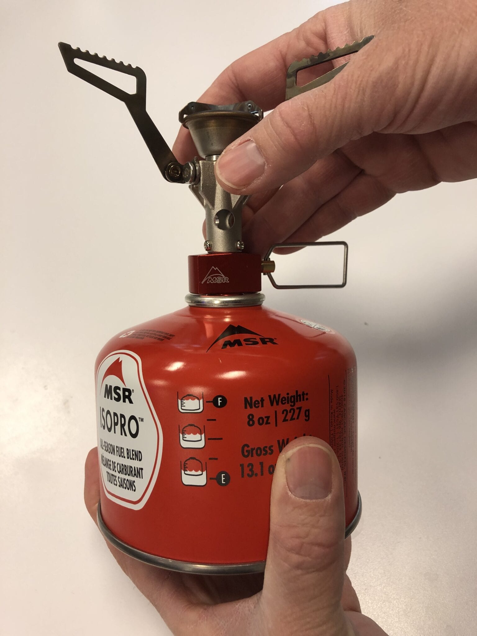
Detach the stove from the canister after the stove cools down.
From my experience with stoves, I suggest disconnecting the stove from the canister after use, and after it has cooled. Keeping a stove attached to the canister for long periods of time increases the chance of a leak. However, I still wondered: how much fuel is lost with every disconnection?
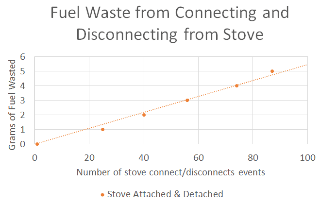
About 0.05 grams of fuel is wasted when you connect and disconnect your stove.
It is always important to follow the instructions that are included with your stove. But in general, you should disconnect your stove from the fuel canister after the stove has cooled off (about 5 minutes after use). Our experiments show that only about 0.05 grams of fuel is lost during the connection and disconnection cycle. To waste just 1 gram of fuel you would have to connect and disconnect the stove about 20 times. Therefore, it is best to disconnect your stove from the canister when the stove is not being used. You will not be wasting much fuel even if it sounds like you are, and you will avoid the possibility of leaking fuel.

Read more!
Check out some related blog posts!
Get our trail guide for this area!
Continental Divide Trail
Considered by many to be the most remote and challenging of the triple crown trails, the Continental Divide Trail is a 3100 mile adventure through five western states.
3100 mi (4980 km) $39.99 full guide
Colorado, Continental Divide Trail
Photo by David Getchel
Colorado, Continental Divide Trail
Photo by David Getchel
Continental Divide Trail
Considered by many to be the most remote and challenging of the triple crown trails, the Continental Divide Trail is a 3100 mile adventure through five western states.
3100 mi (4980 km)
$39.99 full guide
Get our trail guide for this area!
About the Author
Paul Bodnar
Paul has always liked hiking and thru-hiked the Pacific Crest Trail in 1997 after college. After years of working in chemistry, he wanted to create a career involving the outdoors, so he hiked the PCT again in 2010 to do research for his guide book, Pocket PCT. He realized that creating a smartphone app for navigating the outdoors would make it easier to keep the data current and provide a better way to navigate. While hiking with Ryan (aka Guthook) in 2010, they decided to work together to create the first comprehensive smartphone guide for the PCT.
Thru-hiking FAQ Answered by the Community
Planning an adventure? Check out our popular trail guides! 4.8 stars (17K+ ratings)
Thru-hiking FAQ Answered by the Community
Kenna Sarae Kuhn 12/10/2020
Kenna Sarae Kuhn
12/10/2020
We talked to some of our favorite thru-hikers about their experiences and advice for newer hikers. Here is what we learned.
What’s one piece of advice that you have for new thru-hikers?
TWERK “Make sure there is nowhere else in the world that you want to be. If you plan on completing a thru-hike, this will get you through.”
LIZ “It gets easier. Take it day by day.”
JOHN “Cliche but it’s true: Never quit on a bad day.”
KATELIN “Don’t overthink it, just hike. Things will work out in ways you could never imagine.”
SARAH “Train your mind. You’re going to be uncomfortable and have to deal with the unexpected. Prepare your mind to see it out and know it won’t last.”
TAHLIA “Be kind to yourself. The beginning is often the hardest, so be patient with your body as it learns. Everything will get easier, you just have to give it time.”
DAHN “It’s easy to get caught up in the how, where, what, when of a hike… But the most important question to consider is the why? All the other questions have a way of sorting themselves out.”
COTEZI “Make an effort to condition yourself physically as much as you can prior to the hike! Your feet will thank you and you’ll have that much more fun with it.”
What is a piece of luxury gear or food that you never hike without?
TWERK “Camera.”
LIZ “Vegetables and fruits (dried and not) may not be the highest calories per ounce, but they’re worth it.”
JOHN “My inflatable sleeping pad/pillow. A good nights sleep is crucial!”
SARAH “Green tobasco sauce. If you wanna be real ultralight you get a travel shampoo bottle from the store and transfer the precious liquid so you’re not carrying around glass weight.”
AMITHTHAN “Coconut milk powder, but don’t use it as a dairy substitute in your coffee though.”
DAHN “I don’t really consider anything I carry as luxury, even if other people don’t use it or if I could make do with it, I find every piece to be necessary for a successful and enjoyable trip!”
COTEZI “FRESH AVOS!”
How do you prepare for a long hike?
KATELIN “I like to stay active and research the trail. It’s important to me that I respect the areas I’m visiting by learning as much as I can.”
AMITHTHAN “If I am being practical, save up for essential pieces of gear; but more realistically, these days I just try to eat all the things I know I won’t find, even in the most luxe trail town.”
TAHLIA “I’m a Type A nerd, so when it comes to preparation I create lots and lots of spreadsheets – Namely (1) What gear I need (2) My predicted timeline (3) Budgeting and (4) my resupply options.”
DAHN “Get absolutely stoked about what I am about to do, while trying not to ruin any of the surprises/highlights by doing too much research. I find the planning to be just as exciting as the doing.”
COTEZI “Start hiking with a pack on ASAP. Get familiar with the overall trail and towns. Start saving up money.”
What is something you crave incessantly while hiking (food, activities, anything)?
TWERK “I missed cooking in a kitchen!”
JOHN “We all crave the food we can’t have. I miss riding horses while I hike but when home I miss hiking.”
AMITHTHAN “I wish I can have steaming plate of hot white rice and a thick, spicy chicken done up Sri Lankan style in rich, fresh coconut milk and lots of the most perfectly buttery of potatoes — on trail pretty much all the time. Sometimes I wish that the trail is routed around natural hot spring once very 300 miles.”
TAHLIA “A steaming hot shower.”
DAHN “The next view, whatever is around the next bend.”
COTEZI “Pasta and warm bread with butter.”
Cold-soak or stove?
TWERK “Stove.”
LIZ “Stove. I cold soaked for almost the entire Triple Crown. I’m over it.”
KATELIN “I’ve always brought a stove, but for the PCT I’m planning to start without one.”
AMITHTHAN “Cold soak is fine and there’s nothing wrong with taking this route. A stove has benefits that cannot be measured in grams.”
SARAH “Stove forever!! Knowing I can have a hot meal anytime I want is gold.”
TAHLIA “Cold soaking is for aliens.”
DAHN “Neither! Cold soaking is gross, stoves are cumbersome and finicky. I opt for real food.”
COTEZI ” Recently switched to cold-soak. Might not go back!”
Photo provided by Kenna Sarae Kuhn
If you were to re-hike your first long-distance trail, what would you do differently?
TWERK “I would take less zero days in town and more in beautiful places on trail (39 zeroes on my thru in 2018).”\
LIZ “I’ve been lucky to rehike almost all of my first thruhikes. There’s a lot of things I’ve done differently, but I think the most important thing is I’ve finally learned to stop giving into peer pressure and to hike my own hike–stop and take breaks when I want and go the speed I want and to separate what I want from any guilt or meaning associated with that decision.”
KATELIN “I wouldn’t change a thing! I have learned so much from every little moment, the good the bad and the ugly.”
AMITHTHAN “Nothing. AT took me as long as I needed to get to where I wanted to get to in every sense of that word.”
TAHLIA “I wouldn’t put so much pressure on myself to keep up with everyone else. I think learning how to actually “hike your own hike” is very important.”
COTEZI “I’d train my feet better.”
What is something another hiker, friend, or family member has done to support you in your hiking endeavours?
TWERK “My Mom and Dad drove from California to Hart’s Pass to pick me up when I finished. I bawled my eyes out when I saw them. I’ll never forget that day.”
JOHN “Just being supportive and kind. One friend sent me a goody box once that meant a lot to me. The best was a stranger reached out and sent me a care package and a massage while I was on the Te Araroa which was amazing!”
KATELIN “t’s not exactly a specific thing, but making friends with other thru hikers on trail can be such a morale boost. They have gone through the same challenges and can relate on another level. Trail fam will do anything for you.”
AMITHTHAN “Understand[ing] that they don’t quite understand what it is that I am trying to understand or do out there, and encourag[ing] me to find that out on my own terms.”
TAHLIA “My Dad is my biggest supporter. Last week he called in sick so that he could drive me 3.5 hours to Taumarunui (where I had gotten off trail) – all so I wouldn’t have to hitchhike in a storm. He then had to drive all the way back straight after dropping me off. I was really moved that he did this for me.”
DAHN “My family was incredibly supportive of my plan to hike for two years straight, and I feel so fortunate to have a nuclear family that accepted such an outlandish and non-orthodox long term life goal.”
How have you adapted in 2020 to remain safe while still hiking and exploring?
TWERK “I go where I know there won’t be a lot of people.”
LIZ “I’m conscious that some people look to me as an example of what to do in these times. Living in LA county, which has/had some of the highest numbers of cases, I’m extraordinarily cautious about my choices, especially about travel. I didn’t thru hike this year for the first time since 2006. It hurt, but I felt better knowing knowing that I made a choice that felt morally right to me. My hikes were local to the Sierra and all loop hikes that were short enough to do without resupply. They were mostly off trail. And I realized that I got to see all sorts of cool things and places that are in my backyard that I had forgone to hike places farther afield. This year made me explore new things and appreciate what I have–and for that, I’m super grateful.”
AMITHTHAN ” I actually hiked the GDT in 2020 but cancelled the CDT. The decision to hike and not to hike revolved around my responsibility to myself, my loved ones and the hiking community without which thru hiking is simply not possible. Unlike the CDT hike that would have been extremely challenging to avoid too much interaction in vulnerable communities, putting myself and others at risk, I opted for the GDT that was in my own province with bailout options pre-arranged. Thru hiking is selfish but I strongly felt that my selfishness shouldn’t cost somebody else their life or livelihood.”
SARAH “Staying close to home, finding less-populated local trails. Practicing social distancing and wearing a mask.”
TAHLIA “I’m very lucky to live in NZ where we have effectively gotten rid of COVID-19. However I am aware that this can change at any moment so (1) I carry a face mask with me at all times, (2) I keep up with the news so that I’m alerted if anything changes and (3) I check in with NZ’s COVID tracer app everywhere I go so that if there is another outbreak there can be effective contact tracing.”
DAHN “Staying more local, avoiding needless contact with others, respecting ordinances, always having a mask and hand sanitizer on hand, limiting town time.”
What is a funny trail memory that is burned into your mind forever?
LIZ “So many! On the PNT, I ordered a burger called the Mountain Man. The server looked at me like “no way this little lady can eat this!” And tried to talk me out of it. So of course, I ordered it. Ate it. Ate my hiking partner’s extra fries. Downed two beers. All while making sure they saw everything I ate. When I left the Dirty Shame saloon, I was too full to move and my stomach hurt so much, I passed out on the grass across the street. We couldn’t hike out of town and had to get a cabin because I ate too much!”
KATELIN “A bunch of hikers- friends and strangers, packed into a shelter like sardines after a cold, tough rainy day, giggling until we fell asleep. It was the last night on trail and maybe the best.”
AMITHTHAN “I’ll never forget running into a boy scout troupe of about 20 boys going the other way on Naked Hike day somewhere in Virginia; my bubble at the time had three women and three men; one had on a few leaves, another a turtle shell for a “coin purse” and horsehair woven into the his mohawk. None of us had clothing that left much to the imagination. I’ll never forget the dropped jaws on those boys. I’d like to think we inspired some future thru hikers that day.”
SARAH “Just outside of Agua Dulce on the PCT in ‘15 I said goodnight to a few other hikers and zipped up my tent. Another hiker stopped me to ask me if I’d been sleeping in my tent that way since I started the trail.. I was confused and told him yes. Come to find out, I’d been sleeping with my head at the foot-end. We all start somewhere.”
DAHN “Early on, while hiking Te Araroa, in NZ, a couple of friends and I started playing the, put a rock in someone’s pack without them noticing game. One of my fellow hikers managed to sneak in a massive stone into the top of my pack as we left town with a HUGE resupply. The hike out of town was absolutely Sisyphean. When we finally took a break to eat a couple of hours later and I opened up my pack, we all had belly laughs until our abs hurt.”
COTEZI “Crying like a baby in the pit toilet of harts pass after hiking 30 mi back from Canada at the end of my PCT because nobody was there to give me a ride to town. It was like 20 degrees and I had no dry clothes or food left.”
Learn more about these hikers:
Read more!
Check out some related blog posts!
Download our popular hiking and biking guides!
Trail guides that get you to places you’ve dreamed of.
As the makers of Guthook Guides, Bikepacking Guides, and Cyclewayz, we help you navigate the most popular trails around the world on your smartphone. Our hiking guides and biking guides work completely offline. Let Guthook guide your next adventure!
Showers Lake Vista, Tahoe Rim Trail
Photo courtesy of the Tahoe Rim Trail Association
Showers Lake Vista, Tahoe Rim Trail
Photo courtesy of the Tahoe Rim Trail Association
Trail guides that get you to places you’ve dreamed of.
As the makers of Guthook Guides, Bikepacking Guides, and Cyclewayz, we help you navigate the most popular trails around the world on your smartphone. Our hiking guides and biking guides work completely offline. Let Guthook guide your next adventure!
Download our popular hiking and biking guides!
About the Author

Kenna Sarae Kuhn
Kenna grew up in Northern California visiting her grandmother’s cabins along the PCT, which helped catalyze her love for the outdoors and interest in backpacking. She is particularly passionate about the intersection between sustainability and outdoor recreation, connecting with womxn and communities that have been historically underrepresented in outdoor spaces, and pesto pasta. You’re likely to find her having an impromptu dance party with her pup, whether it’s while backpacking, climbing, mountain biking, or just on the side of the road.
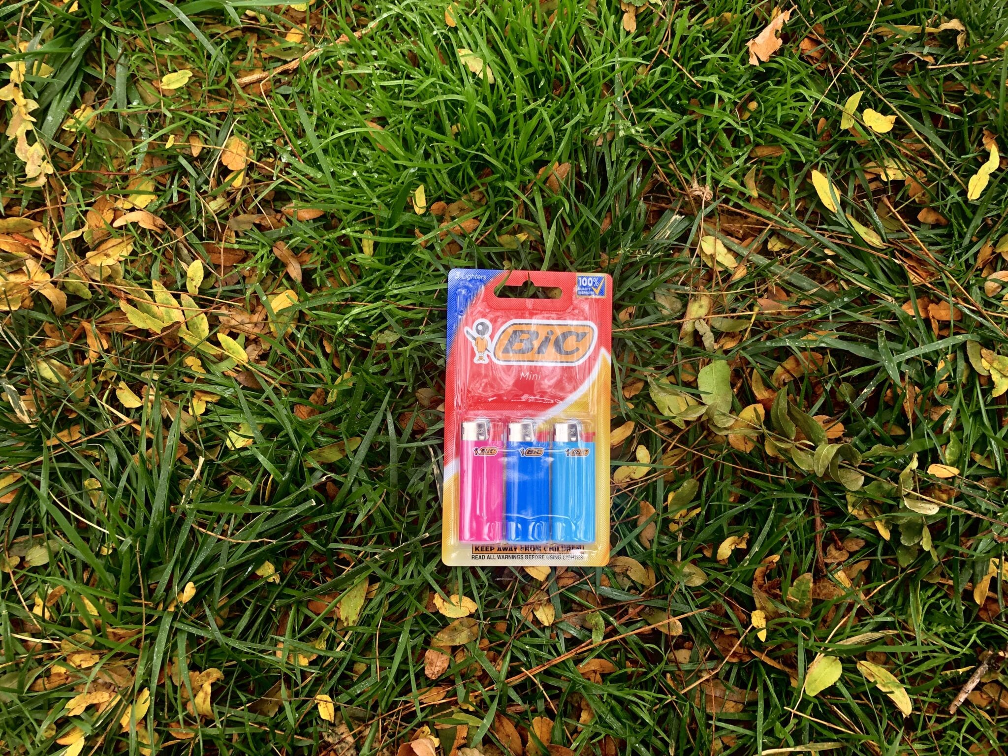
Will a BIC Mini Lighter Last for Your Entire Thru-Hike?
Planning an adventure? Check out our popular trail guides! 4.8 stars (17K+ ratings)
Will the BIC Mini Lighter Last for Your Entire Thru-Hike?
The BIC Mini lighter is one of the most popular lighters for thru-hiking and backpacking. We ran some tests to see how long a BIC Mini lighter would last.
Paul Bodnar Gear Review 10/22/2020
Paul Bodnar
Gear Review
10/22/2020
The BIC Mini is one of the most popular lighters used for long-distance hiking. This is because it is small (2 ⅜ inches long and ⅞ inches wide and less than ½ inch thick) and lasts a long time. It is very common for a single BIC Mini to last an entire 2,000 mile hike with plenty of fuel to spare.
Weight Full: 11.5 grams (0.41 ounces)
Weight Empty: 9.3 grams (0.33 ounces)
Total Fuel Weight: 2.2 grams (0.08 ounces)
Estimated Number of Lights: 2,200
Typical Cost: $1
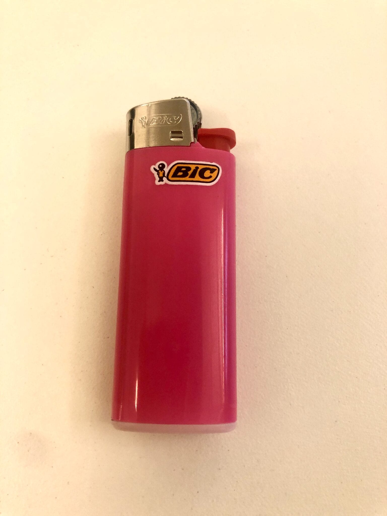
How long will the BIC Mini last?
The Bic Mini lighter will provide around 2,200 lights but it really does depends on the burn-time of the flame. If you are lighting a stove, you will likely use a 0.75 second flame and burn around 0.001 grams of fuel. This means you have about 2,200 lights from a BIC Mini. However, if you are lighting a campfire, you will probably need at least a 3-second flame, which burns about 0.004 grams of fuel. In this case you will get about 530 lights from the BIC Mini. In either case a full BIC Mini could easily last an entire 5 to 6 months with daily use. From our tests we estimate that the BIC Mini can produce a flame for a total of about 26 minutes at an average burn rate of about 0.0014 grams per second. The manufacturer states that the lighter should not stay lit for more than 30 seconds.

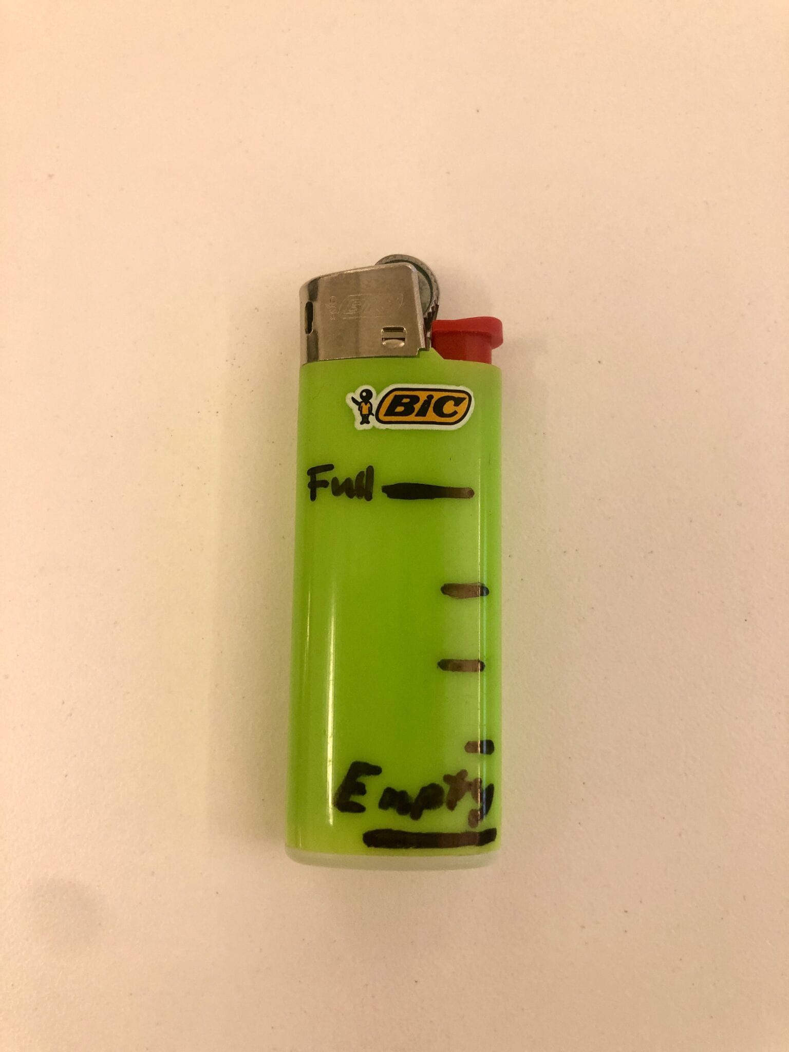
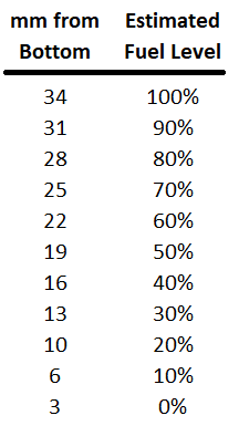
How to Estimate Remaining Fuel
Shine a bright light on the edge of the lighter to illuminate the fuel inside the lighter. Illuminating the lighter in a dark area can make it easier to see the fuel level. Measure the distance from the bottom of the lighter to the fuel level in the lighter. See chart below to estimate the percentage of fuel remaining.
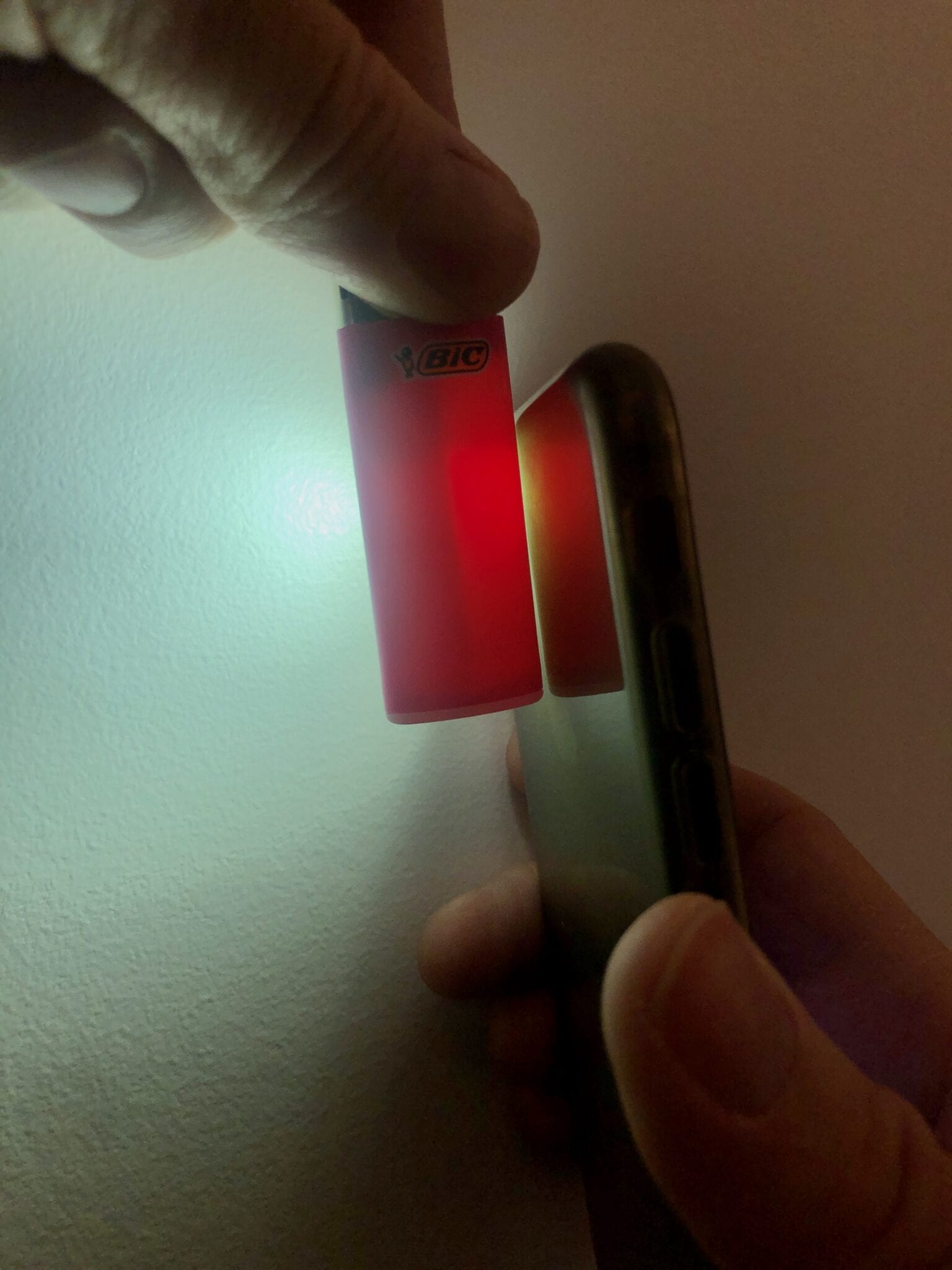
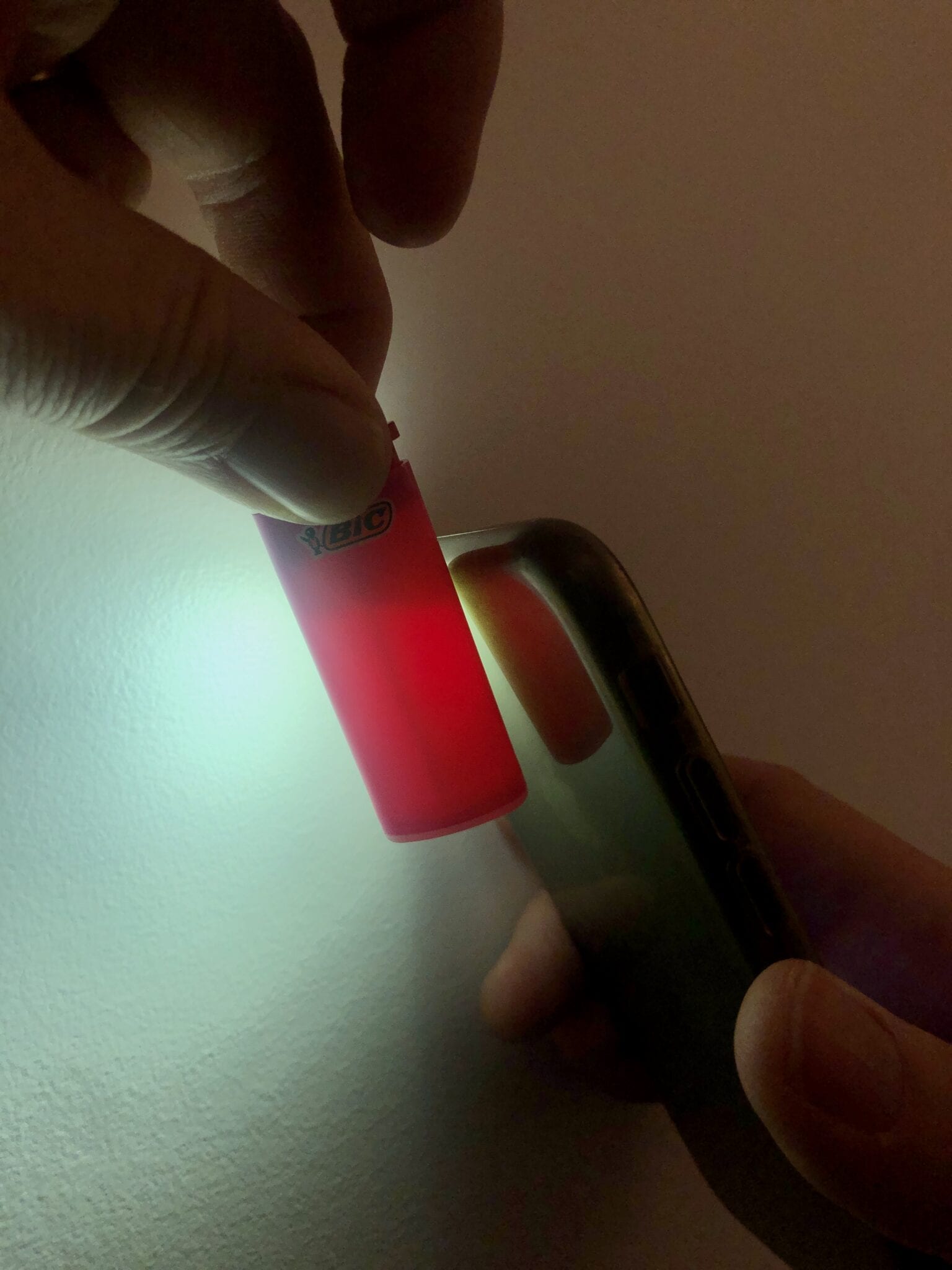
Tip: Mark the full and empty position on the lighter with a permanent marker to create your own fuel gauge.
Read more!
Check out some related blog posts!
Download our popular hiking and biking guides!
Trail guides that get you to places you’ve dreamed of.
As the makers of Guthook Guides, Bikepacking Guides, and Cyclewayz, we help you navigate the most popular trails around the world on your smartphone. Our hiking guides and biking guides work completely offline. Let Guthook guide your next adventure!
Showers Lake Vista, Tahoe Rim Trail
Photo courtesy of the Tahoe Rim Trail Association
Showers Lake Vista, Tahoe Rim Trail
Photo courtesy of the Tahoe Rim Trail Association
Trail guides that get you to places you’ve dreamed of.
As the makers of Guthook Guides, Bikepacking Guides, and Cyclewayz, we help you navigate the most popular trails around the world on your smartphone. Our hiking guides and biking guides work completely offline. Let Guthook guide your next adventure!
Download our popular hiking and biking guides!
About the Author
Paul Bodnar
Paul has always liked hiking and thru-hiked the Pacific Crest Trail in 1997 after college. After years of working in chemistry, he wanted to create a career involving the outdoors, so he hiked the PCT again in 2010 to do research for his guide book, Pocket PCT. He realized that creating a smartphone app for navigating the outdoors would make it easier to keep the data current and provide a better way to navigate. While hiking with Ryan (aka Guthook) in 2010, they decided to work together to create the first comprehensive smartphone guide for the PCT.
12 Backpacking Foods You Can Cram in a Bear Canister
Planning an adventure? Check out our popular trail guides! 4.8 stars (17K+ ratings)
12 Backpacking Foods You Can Cram in a Bear Canister
We analyzed the calorie density of 12 different backpacking food items to illustrate the theoretical maximum number of calories that can be placed in a BearVault BV500 bear canister. Every food has a different calorie density and the way it is packaged also influences calorie density.
Paul Bodnar Educational 10/16/2020
Paul Bodnar
Educational
10/16/2020
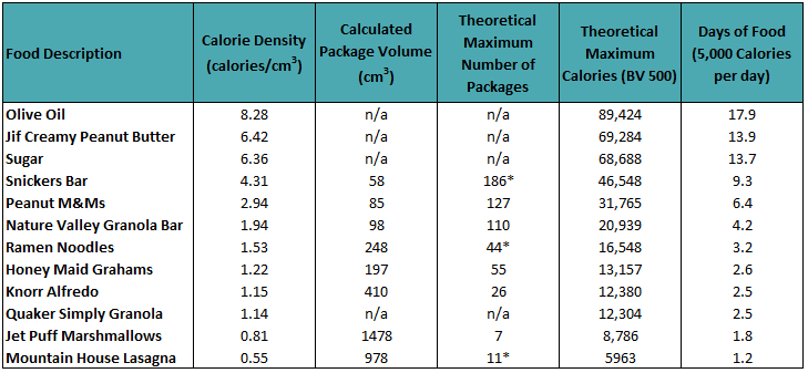
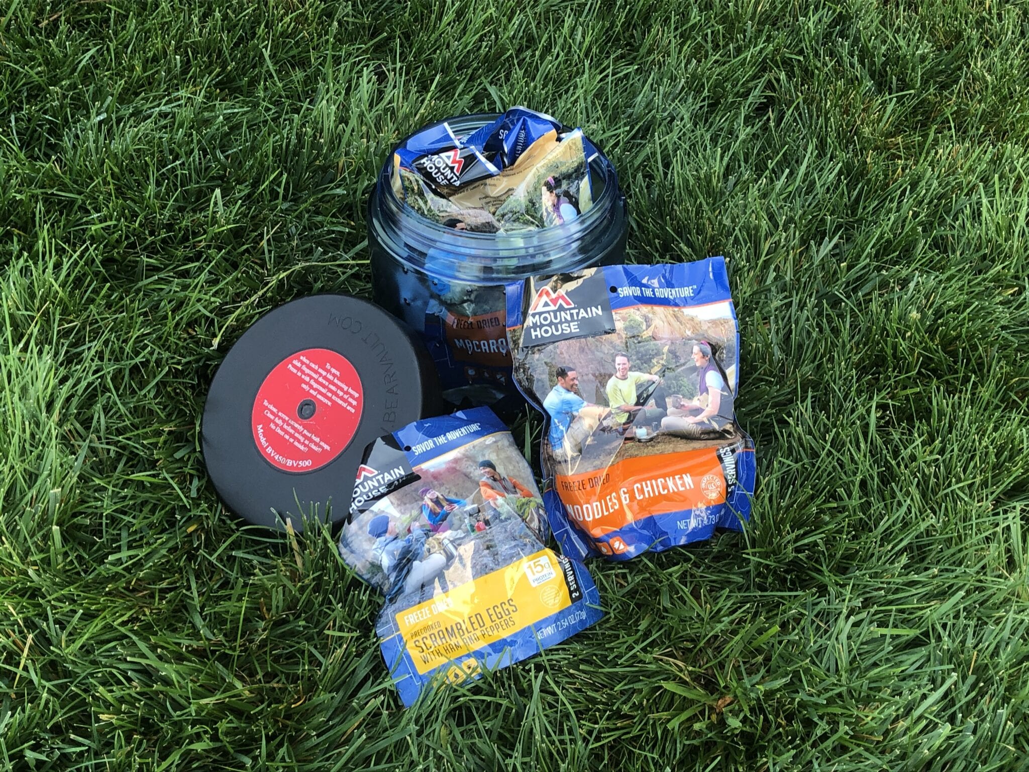
*The actual number of Snickers Bars and Ramen Noodles that we were able to fit in a BV500 was 143 and 24 respectively. The difference in the theoretical maximum and actual can be significant depending on spacing between packages. Surprisingly when packing a variety of Mountain House meals we were able to fit a total of 10 packages inside a BV500 with a total calories of 5,945. This matched closely with the theoretical numbers.
The purpose of the chart above is to illustrate the differences in different types of food and how it impacts the number of days of food in a bear canister. We do not suggest you will eat the exact same food every day or pack you bear can with olive oil to maximize your calories. We are just showing theoretical maximums in calories and estimated days of food to illustrate the differences in calorie density for different foods. If you want to maximize the number of calories or days of food in your bear canister it is best to select high calorie density food.
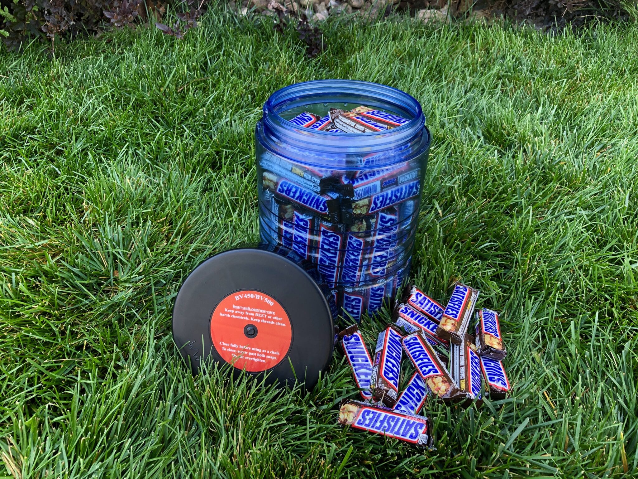

The BV500 used for this test has a measured (as opposed to published) volume of 10.8 liters or 10,800 cm3 . The equation above illustrates how the theoretical maximum number of calories inside a BV500 is calculated. You can use the same equation to calculate the calorie maximum for different sized bear canisters.
A healthy variety of food is important.
It is especially important to pack healthy food when packing your bear canister. Sometimes healthy food might not be as calorie rich as other high fat foods. This doesn’t not reduce the value of healthy food in your diet.

Read more!
Check out some related blog posts!
Download our popular hiking and biking guides!
Trail guides that get you to places you’ve dreamed of.
As the makers of Guthook Guides, Bikepacking Guides, and Cyclewayz, we help you navigate the most popular trails around the world on your smartphone. Our hiking guides and biking guides work completely offline. Let Guthook guide your next adventure!
Showers Lake Vista, Tahoe Rim Trail
Photo courtesy of the Tahoe Rim Trail Association
Showers Lake Vista, Tahoe Rim Trail
Photo courtesy of the Tahoe Rim Trail Association
Trail guides that get you to places you’ve dreamed of.
As the makers of Guthook Guides, Bikepacking Guides, and Cyclewayz, we help you navigate the most popular trails around the world on your smartphone. Our hiking guides and biking guides work completely offline. Let Guthook guide your next adventure!
Download our popular hiking and biking guides!
About the Author
Paul Bodnar
Paul has always liked hiking and thru-hiked the Pacific Crest Trail in 1997 after college. After years of working in chemistry, he wanted to create a career involving the outdoors, so he hiked the PCT again in 2010 to do research for his guide book, Pocket PCT. He realized that creating a smartphone app for navigating the outdoors would make it easier to keep the data current and provide a better way to navigate. While hiking with Ryan (aka Guthook) in 2010, they decided to work together to create the first comprehensive smartphone guide for the PCT.

Highest & Lowest Points on the PCT/AT/CDT
Planning an adventure? Check out our popular trail guides! 4.8 stars (17K+ ratings)
Highest & Lowest Points on the PCT, AT, CDT
What are the highest and lowest points on the Triple Crown Trails (Pacific Crest Trail, Appalachian Trail, and Continental Divide Trail)? Find out by taking a look at our elevation profile data.
Kenna Sarae Kuhn Explore New Trails 10/09/2020
Kenna Sarae Kuhn
Explore New Trails
10/09/2020
Pacific Crest Trail
Highest Point: Forester Pass, California
- 13,153 feet (4,009 m)
Lowest Point: Cascade Locks, Oregon
- 140 ft (43 m)

Forester Pass

Elevation profile of Forester Pass from the Guthook Guides app
Appalachian Trail
Highest Point: Clingmans Dome, Tennessee
- 6,643 ft (2,025 m)
Lowest Point: Bear Mountain State Park, New York
- 124 ft (38 m)

Clingmans Dome
Elevation profile of Clingmans Dome from the Guthook Guides app
Continental Divide Trail
Highest Point: Grays Peak, Colorado
- 14,278 ft (4,352 m)
Lowest Point: Waterton Canyon, Montana
- 2,972 ft (906 m)

Grays Peak

Elevation profile of Grays Peak from the Guthook Guides app
Want to keep up with all that’s going on at Atlas Guides? Sign up for our newsletter!
Read more!
Check out some related blog posts!
Get our trail guide for this area!
Continental Divide Trail
Considered by many to be the most remote and challenging of the triple crown trails, the Continental Divide Trail is a 3100 mile adventure through five western states.
3100 mi (4980 km) $39.99 full guide
Colorado, Continental Divide Trail
Photo by David Getchel
Colorado, Continental Divide Trail
Photo by David Getchel
Continental Divide Trail
Considered by many to be the most remote and challenging of the triple crown trails, the Continental Divide Trail is a 3100 mile adventure through five western states.
3100 mi (4980 km)
$39.99 full guide
Get our trail guide for this area!
About the Author
Kenna Sarae Kuhn
Kenna grew up in Northern California visiting her grandmother’s cabins along the PCT, which helped catalyze her love for the outdoors and interest in backpacking. She is particularly passionate about the intersection between sustainability and outdoor recreation, connecting with womxn and communities that have been historically underrepresented in outdoor spaces, and pesto pasta. You’re likely to find her having an impromptu dance party with her pup, whether it’s while backpacking, climbing, mountain biking, or just on the side of the road.