CATlas Guides
Planning an adventure? Check out our popular trail guides! 4.8 stars (17K+ ratings)
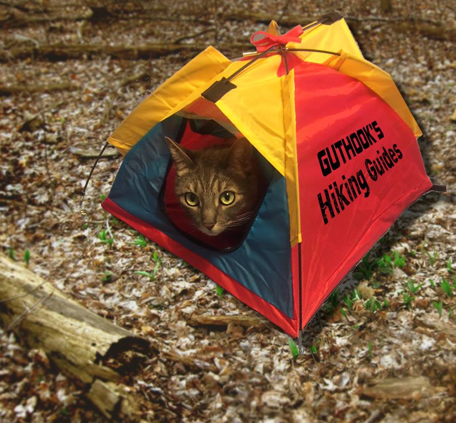
April Fools!
CATlas Guides is not real. 😉 We just hoped to bring a smile to your face! Silver, the Guthook Guides cat, wishes you all her best and hopes you are all staying healthy and safe out there.

Read more!
Check out some related blog posts!
Download our popular hiking and biking guides!

Trail guides that get you to places you’ve dreamed of.
As the makers of Guthook Guides, Bikepacking Guides, and Cyclewayz, we help you navigate the most popular trails around the world on your smartphone. Our hiking guides and biking guides work completely offline. Let Guthook guide your next adventure!
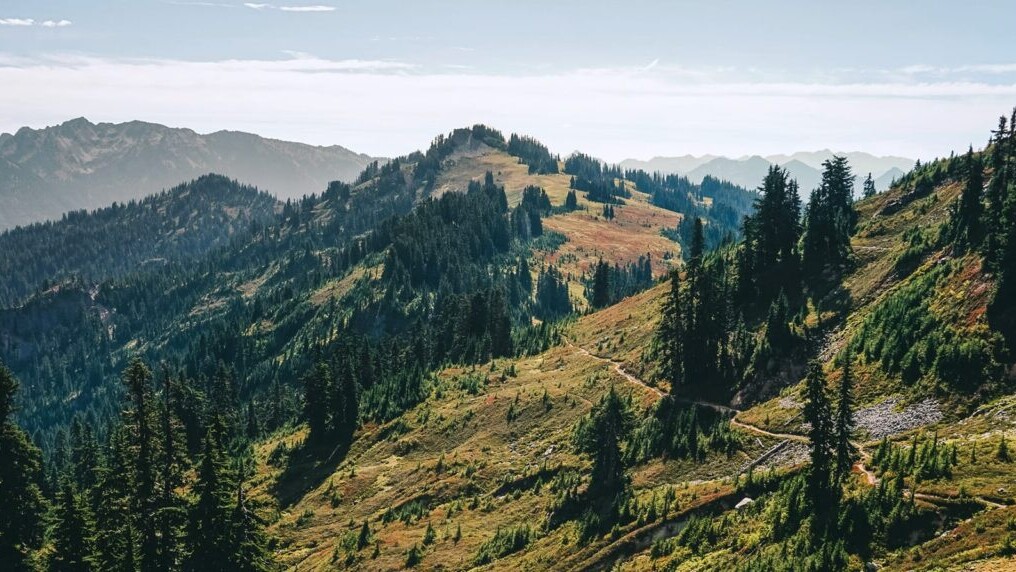
Showers Lake Vista, Tahoe Rim Trail
Photo courtesy of the Tahoe Rim Trail Association

Showers Lake Vista, Tahoe Rim Trail
Photo courtesy of the Tahoe Rim Trail Association
Trail guides that get you to places you’ve dreamed of.
As the makers of Guthook Guides, Bikepacking Guides, and Cyclewayz, we help you navigate the most popular trails around the world on your smartphone. Our hiking guides and biking guides work completely offline. Let Guthook guide your next adventure!
Download our popular hiking and biking guides!
About the Author

Natalie McMillan
Natalie grew up hiking in Arizona where she fell in love with the outdoors. Her favorite hikes are to Havasu Falls in the Grand Canyon and Angel’s Landing in Zion National Park, UT. She loves taking pictures of people, places, and nature, which might explain why she has almost 47,000 photos currently residing on her phone. She takes care of all things related to social media and marketing and recently moved to Denver, CO from Flagstaff, AZ. You may find her frolicking around the trails and mountains of Colorado, or exploring the new city she gets to call home.
My (Postponed) Trail Story by Flamingo
Planning an adventure? Check out our popular trail guides! 4.7 stars (14K+ ratings)
Photo by Phill Toomasian
My (Postponed) Trail Story featuring Flamingo
Phill Toomasian, a.k.a. "Flamingo", was attempting a Calendar Year Triple Crown until he had to get off the Appalachian Trail due to COVID-19.
Natalie McMillan My Trail Story 03/27/2020
Natalie McMillan
My Trail Story
03/27/2020
After 1,000 miles of hiking on the Appalachian Trail, I was flying. I was far ahead of the population of thru-hikers and on track to hit the White Mountains early enough that snowshoes were not to be ruled out. I started February 9th and averaged over twenty-six miles a day. I was set to finish the first half of the trail in less than forty days. Despite how far I had gone and the speed at which I was going, I finally felt like I was adjusting to the trail. It took me a long time to get used to how hard this trail is. I finally felt like I wanted to be there.

Photo by Phill Toomasian
Amidst an attempt to hike the Appalachian, Continental Divide, and Pacific Crest Trail Systems, my trail legs felt like they were coming in. I felt strong and capable. The problem now was that instead of my mind being occupied by the miles and riddles of handling hours of solitude, I had to face this new dilemma. Despite a life distant from civilization I couldn’t help from being just as updated on the Covid-19 crisis as well as anyone else.
The Appalachian Trail Conservancy (ATC) began encouraging and then urgently asking hikers to get off the trail. When it first began, I thought to myself, “This request was not made for me.” To be fair, it really was not. There were very few hikers who had already done half of the AT this year. I had been so detached from civilization and my chance of being sick was that of a lottery ticket. I was not concerned with my safety, nor was I concerned about spreading a virus. As the situation became more severe my thoughts shifted to “Can I charge my phone? Can I resupply?” These were the only things I really needed. If anyone were entitled to stay on the trail it would have been me. I mean come on 1,000 miles and all I do is visit the grocery store like everyone else. This did not stop the fear of others though, and that is what made me nervous.
My life experiences in the backcountry and general understanding of life have indicated to me that people in a panic are not very good at making decisions. I had been generating a list of emergency contacts as I headed Northbound, but I was afraid that frightened friends could easily become strangers. I was worried that the trail might close and I would be stuck looking for a place to go. Amidst all of this, I had gained a unique position over social media. I was attempting something great and a lot of people were watching what I was doing. Maybe I personally would not be spreading a virus, but could my actions be encouraging people to start their hikes? I knew what I had to do. I had to get off the trail.

Photo by Phill Toomasian
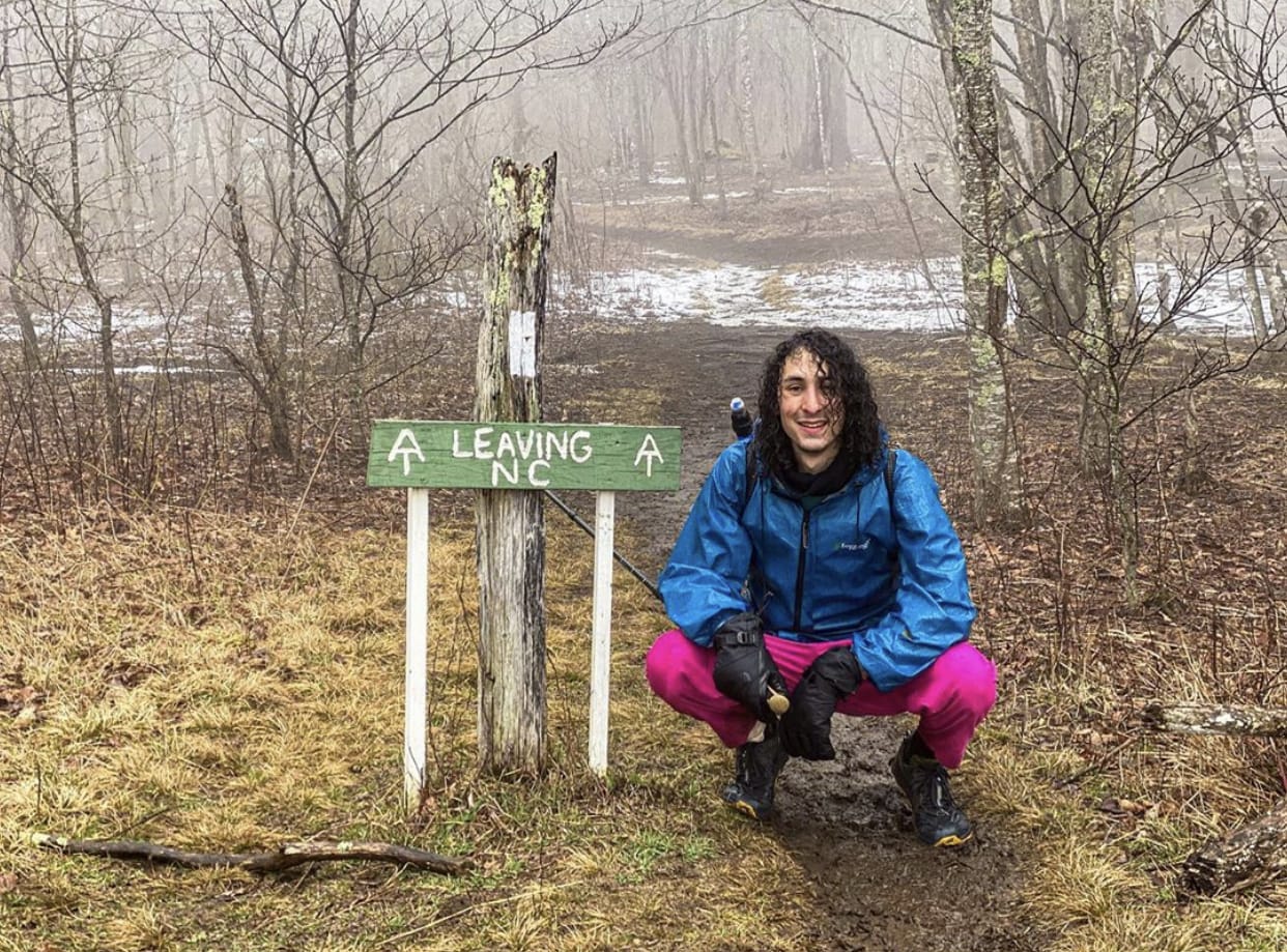
I was fortunate enough to have a great friend in Northern Pennsylvania who came and got me. I had just crossed into Maryland, and my plan was to hike for a few more days and get picked up. After I planned this, I slept in and didn’t plan my usual high mileage day as it did not seem to matter. I woke to find signs everywhere noting that camping in Maryland on the AT was closed. Had I woken up earlier I could have easily hiked out of the state that day, but I was not going to break the law. I called my hike in a day early. My hike was postponed after a short twenty-four mile day. Had I done nine more miles I would have crossed another state line, but this would have to do for now.
It was not that hard of a decision to make in all honesty. I was not even that sad to get off the trail. Maybe my past thousand miles have taught me that I am not in control of anything and so I came to peace with it immediately. Perhaps I’ve grown numb and have yet to really process what I feel I am missing out on right now. It is hard to say. I still hope that my goal of a Calendar Year Triple Crown is alive, but it is likely gone. I plan on finishing the AT and hiking the CDT at least if this pandemic takes too long to clear up.

Photo by Phill Toomasian
I do have one hope that I am contemplating, but it is quite a long shot. I feel the only way I could responsibly hike right now is if I were doing the New Mexico portion of the CDT. The only way it is possible in my opinion is to have someone living in a vehicle supporting me. They would be picking up my boxes, charging my electronics for me. I could quarantine myself on the trail and they could quarantine themselves in their home. New Mexico is the only stretch of trail on the Triple Crown that I would do this too. It is desolate and hardly a trail in many places. The number of day hikers would be low. In addition, I would stay off of social media. I wouldn’t want to encourage anyone to thru-hike right now if they could not guarantee isolation. Maybe I will be able to get out there soon, but do not think I can count on that.
So now, I will do what everyone else is doing (or should be doing) and I am waiting this out. It is true that I possess a huge goal that I am most likely going to have to give up on. That sucks, it really does, but I would be selfish and arrogant to act like I am the only one affected by this pandemic. I mean come on, this is a world dilemma.
Want to keep up with all that’s going on at Atlas Guides? Sign up for our newsletter!
Read more!
Check out some related blog posts!
Get our trail guide for this area!
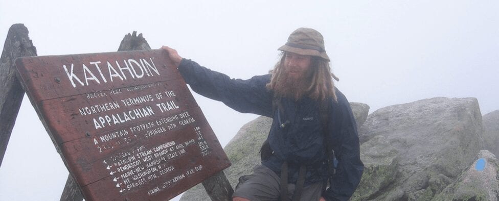
Appalachian Trail
The Appalachian Trail is one of the oldest National Scenic Trails in the US. Its path takes you from Springer Mountain in Georgia to Mt. Katahdin in Maine.
2200 mi (3540 km) $59.99 full guide
Pennsylvania, Appalachian Trail
Photo by Zoë Symon
Pennsylvania, Appalachian Trail
Photo by Zoë Symon
Appalachian Trail
The Appalachian Trail is one of the oldest National Scenic Trails in the US. Its path takes you from Springer Mountain in Georgia to Mt. Katahdin in Maine.
2200 mi (3540 km)
$59.99 full guide
Get our trail guide for this area!
About the Author
Natalie McMillan
Natalie grew up hiking in Arizona where she fell in love with the outdoors. Her favorite hikes are to Havasu Falls in the Grand Canyon and Angel’s Landing in Zion National Park, UT. She loves taking pictures of people, places, and nature, which might explain why she has almost 47,000 photos currently residing on her phone. She takes care of all things related to social media and marketing and recently moved to Denver, CO from Flagstaff, AZ. You may find her frolicking around the trails and mountains of Colorado, or exploring the new city she gets to call home.

Thru-hiking Gear Review - Deschutes Zero-G Shelter
Planning an adventure? Check out our popular trail guides! 4.8 stars (17K+ ratings)
Photo provided by Dahn Pratt
Thru-hiking Gear Review: Deschutes Zero-G Shelter
On the Continental Divide Trail unpredictable weather conditions necessitate choosing gear wisely. A Triple Crown hiker explains his decision to bring a Deschutes Zero-G shelter on his 2019 thru-hike of the CDT.
Dahn Pratt Gear Review 03/20/2020
Dahn Pratt
Gear Review
03/20/2020
10,000 miles of Thru-Hiking
Gear; Deschutes Zero-G
Without much practice or knowledge of free-standing tarp-style shelters I brought what amounted to a thin sheet of fabric on my thru-hike of the infamously grueling Continental Divide Trail, a 3,000 mile hike from Canada to Mexico. It was my first foray into the ultralight textile known as Dyneema Composite Fabric (DCF), also known as cuben fiber, but the lightweight fabric proved to be the best piece of thru-hiking gear I used in 2020.
DCF is quickly becoming an essential item on any thru-hiking gear list, and as the popularity of the trails grow, the use of ultralight backpacking gear has also increased. Prior to my hike on the CDT, I was dubious of the practicality for such an expensive fabric. But within the first week of using it, I was a convert.
After a grueling day in the Bob Marshall Wilderness, with over 17,000 ft of elevation gain and 37 miles of tough trail, I settled in for the night, completely spent. It wasn’t my intention to go so far in a single day, especially since I was less than a week into my thru-hike of the CDT. But circumstances dictated I push on, as a majority of the day’s walk was spent above tree-line in very exposed terrain.

The southern end of the Bob Marshall Wilderness aka “The Bob” one of the most remote places in the contiguous US. Photo by Dahn Pratt
Just as the day was ending a thunderstorm began to brew overhead. This was a signal it was time to get somewhere relatively safe.

Photo by Dahn Pratt
As the blue skies turned to an angry gray, my hiking partner and I quickly descended from the exposed ridge to the relative calm of the lower elevations.
A small seasonal alpine tarn near Caribou Peak provided the first tree-cover for miles in any direction. The relief of being under some sort of cover for the first time during the moody weather I had come to expect from Montana was definitely welcomed.

Photo by Dahn Pratt
We had just enough time to crawl into our shelters before the skies began to unload on us. Quarter sized bullets of hail and ear-shattering thunder had me in a fetal position most of the night as frequent and terrifyingly close lightning lit up the interior of my tarp. The barrage lasted several hours and the fear of getting hit by lightning, having my shelter torn to shreds by hail and wind, or having a tree collapse on me all but insured a sleepless night.
In the morning we awoke to a calm, cloudless sky and my hiking partner Vortex looked at me perplexed. There were shards of glass around both of our shelters. A particularly large piece was near where my head had laid the previous night. We had cleared the site prior to putting our tarps down, which had become our thru-hiking ritual, and were dumbfounded to find the glass in our respective sites. Could we really have missed these sharp pieces of glass? We would later find out that the lightning strikes had hit the sandy beach of the small lake we slept beside, fusing the sand into silica glass.
From that day forward, I knew my shelter was bomb-proof!
The Deschutes Zero-G is a DCF shelter with a stated weight of 8 oz (226 grams) although my scale read 222 grams or about 7.8 oz (including the stuff sack but excluding stakes and pole).

Photo by Dahn Pratt
The set-up is pretty intuitive as the shelter only uses a single pole, which was a major draw for me (I have a tendency to snap trekking poles). Even with no real tarp experience, my first time setting it up took ~5 minutes to get a taught pitch.

Quick, easy, and taut pitch, everytime! by Dahn Pratt
Deschutes Zero-G + SerenityNet inner. A fully enclosed double-walled shelter at 19 oz. Photo by Dahn Pratt
Using a piece of Tyvek as a groundsheet and a SMD Serenity Net provided me with a fully enclosed double-walled shelter. The added benefit being the modular nature of having a detachable inner for clear nights or just the Deschutes for bugless nights.
One of the reasons I absolutely loved the Deschutes was its ability to pitch in precarious spots. With its tiny footprint, most sites that would otherwise be off-limits to other hikers were perfect “nests” for me.

After crossing the Wyoming/Colorado border the deadfalls limited safe camping areas, but it had no material impact on the small footprint my Deschutes took up
Photo by Dahn Pratt

With nowhere flat and plantless to set up in the Great Divide Basin, I had to set up shop on a seemingly endless dirt road.
Photo by Dahn Pratt
After proving its worth in the berserk weather of the Divide, I spent the next ten months across seven countries and 5,000 miles with the Deschutes Zero-G as my roof. Completing a year of back-to-back thru-hikes made me more comfortable and well versed in the outdoors than ever before. With this new-found sense of confidence and the Deschutes in my pack, I never doubted its ability in any condition. The increasingly precarious and outright ridiculous places where it was able to perform exceptionally well warranted its new nickname as my “all-terrain vestibule”.

The Deschutes Zero-G in an epic off-trail campsite in sub-Antarctic Patagonia.
Photo by Dahn Pratt

Even with furious winds and constant rain I always stayed dry and cozy inside my “hiker’s nest”. Photo by Dahn Pratt
Author’s disclaimer: This tarp was given to me by Six Moon Designs as part of their Ambassador’s program in 2019
Want to keep up with all that’s going on at Atlas Guides? Sign up for our newsletter!
Read more!
Check out some related blog posts!
Get our trail guide for this area!
Continental Divide Trail
Considered by many to be the most remote and challenging of the triple crown trails, the Continental Divide Trail is a 3100 mile adventure through five western states.
3100 mi (4980 km) $39.99 full guide
Colorado, Continental Divide Trail
Photo by David Getchel
Colorado, Continental Divide Trail
Photo by David Getchel
Continental Divide Trail
Considered by many to be the most remote and challenging of the triple crown trails, the Continental Divide Trail is a 3100 mile adventure through five western states.
3100 mi (4980 km)
$39.99 full guide
Get our trail guide for this area!
About the Author

Dahn Pratt
Dahn is an avid taker-of-walks. He has hiked the Triple Crown of National Scenic Trails in the United States, Te Araroa in New Zealand, the Peace Trail through Jordan and Israel, and various other routes and trails around the world. His most recent escapades called “Chasing Summer” had him hiking long distance trails, oscillating between North and South Hemispheres in perpetual summer.
How to Send a Check-In in the Guthook Guides App
Planning an adventure? Check out our popular trail guides! 4.8 stars (17K+ ratings)
How to Send a Check-In in the Guthook Guides App
Our new social check-in feature helps hikers keep in touch with their friends and family on a long hike.
Natalie McMillan Tech on the Trail 03/13/2020
Natalie McMillan
Tech on the Trail
03/13/2020
Here are step-by-step instructions to send a Check-in from the Guthook Guides app.
Find more information about our new social check-in feature: Social Features Page
Android: How to send a check-in
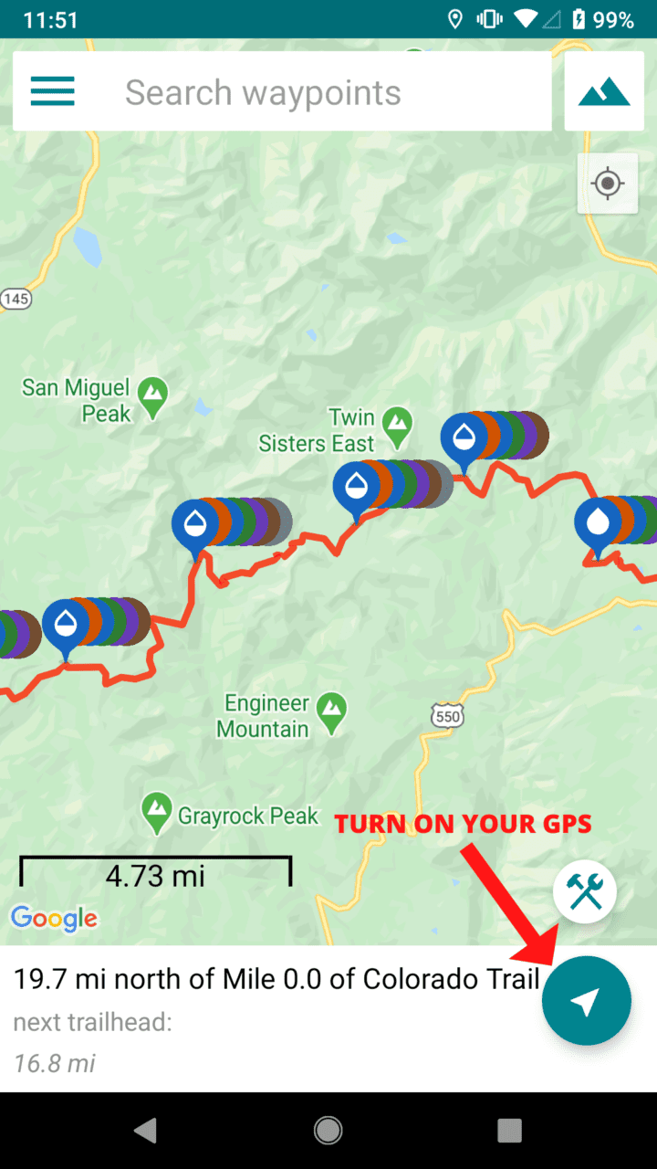
- Make sure you turn on your GPS. (The button will turn blue when it’s ON and grey when it’s OFF.)
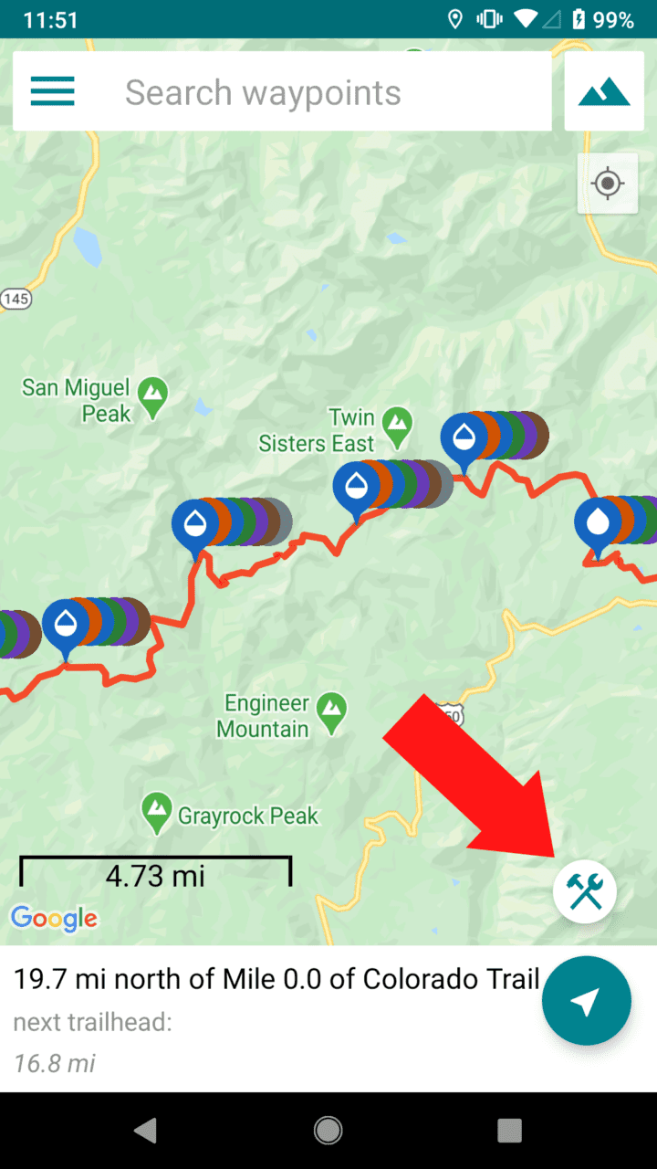
2. Tap the “Tools” button above the GPS button
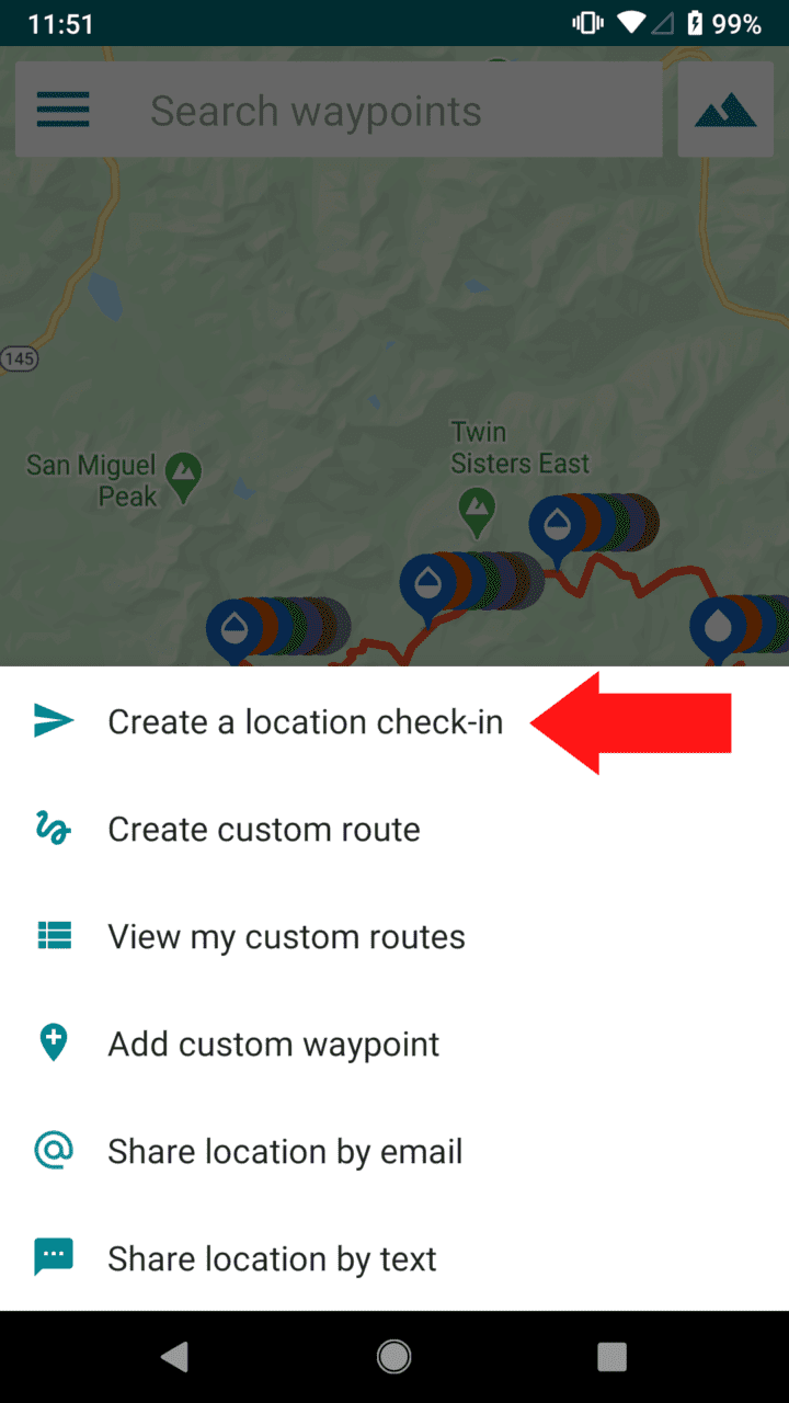
3. Tap “Create a location check-in”
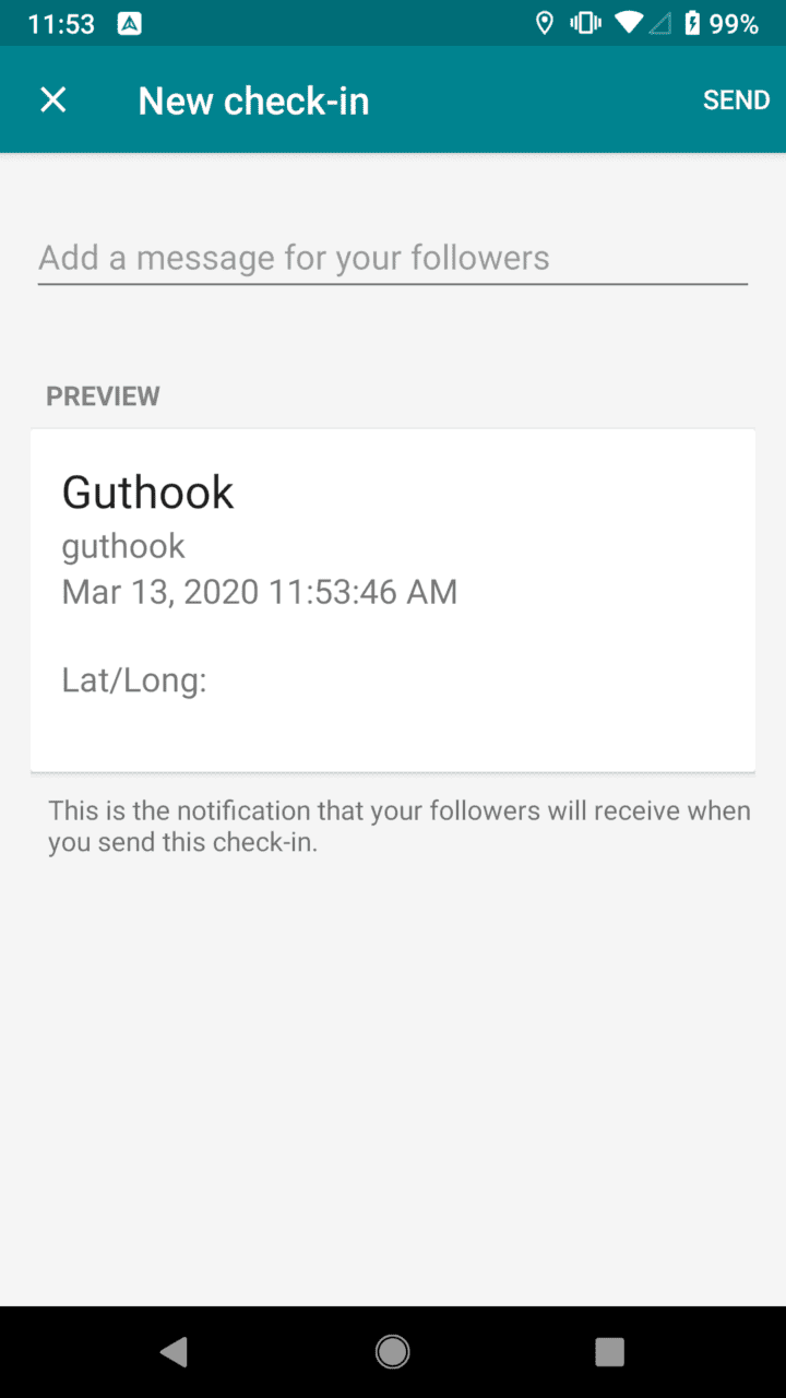
4. Write a message (optional) and send a check-in (Your phone must have cell service or be connected to wifi for the check-in to send)
iPhone: How to send a check-in
OPTION 1:
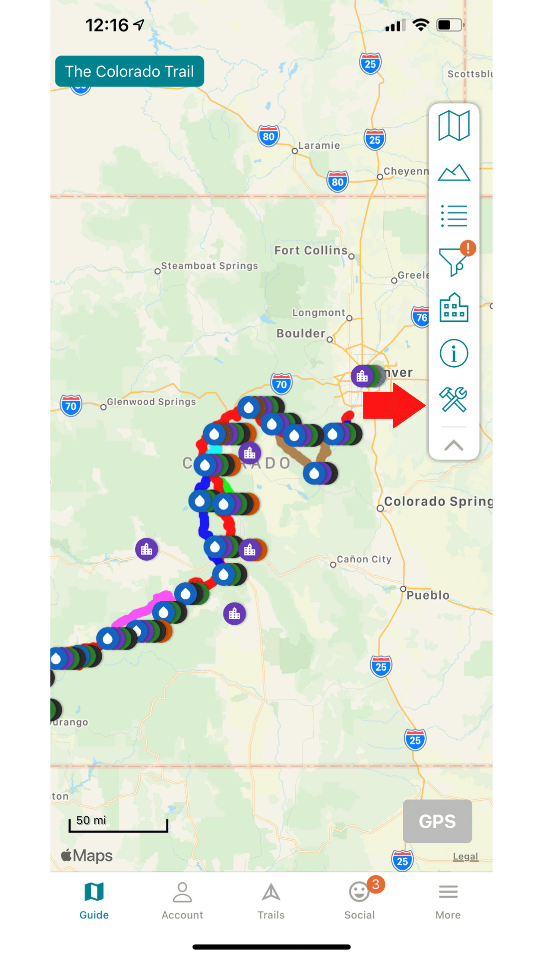
- Go to the Map page and tap on the “tools” tab in the control panel on the right side of the screen.
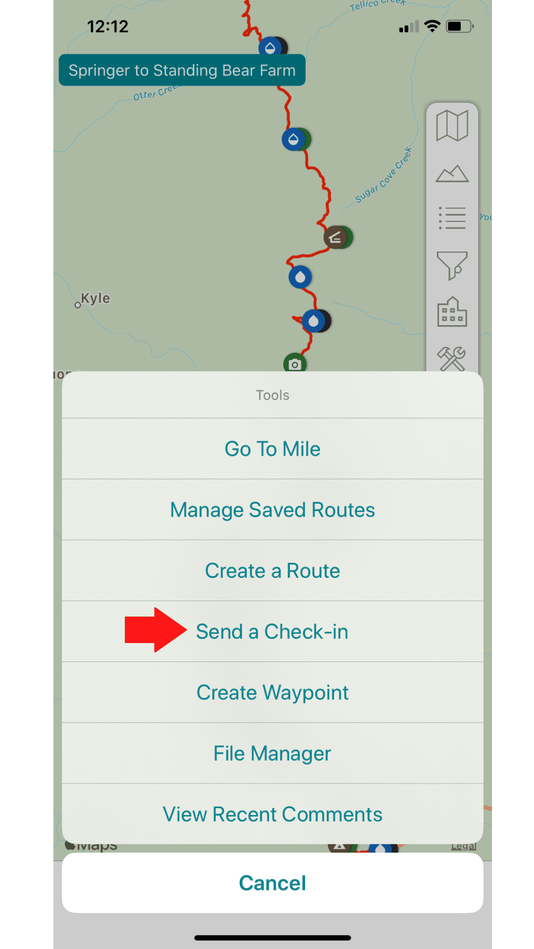
2. Tap “Send a Check-in”
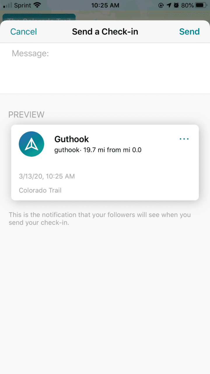
3. Write a message (optional) and send a check-in (Your phone must have cell service or be connected to wifi for the check-in to send)
OPTION 2:
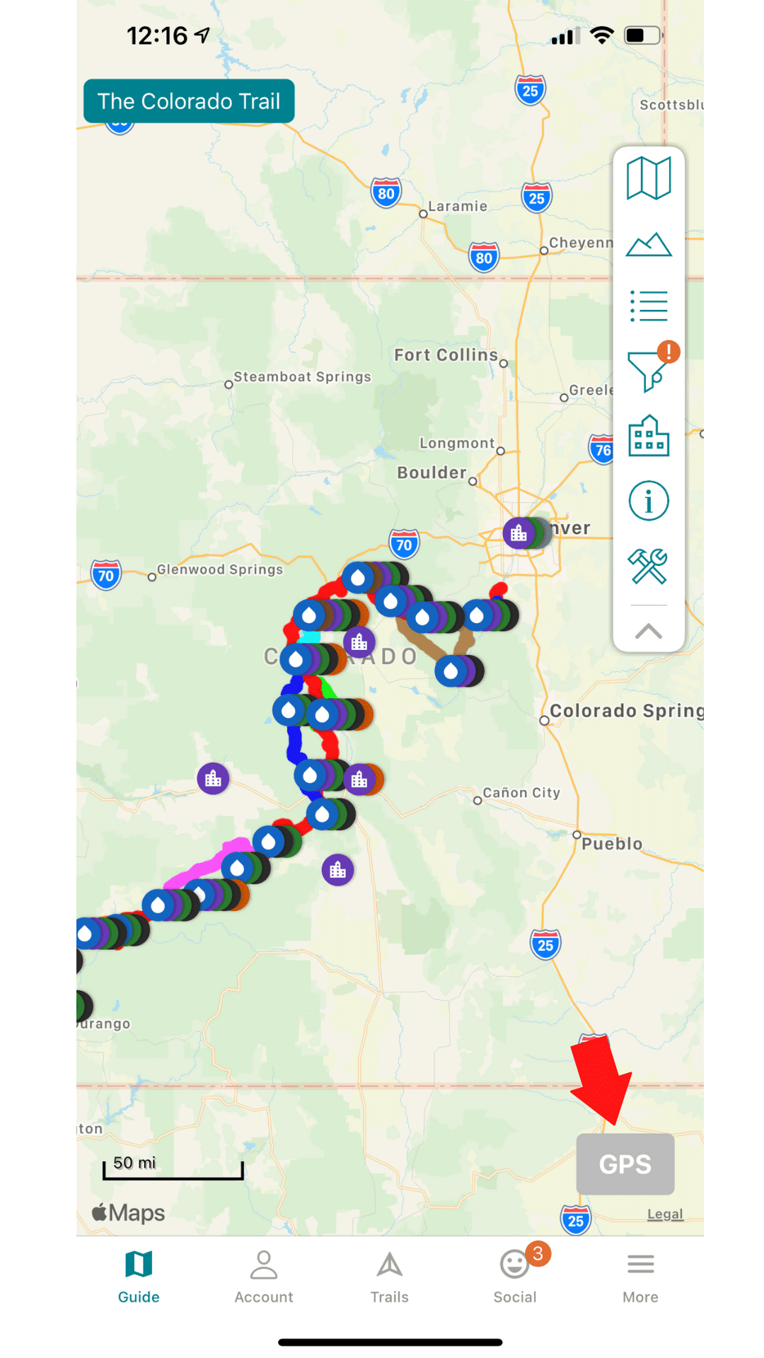
1. Go to the Map page and tap on the Grey “GPS” button in the bottom right hand corner
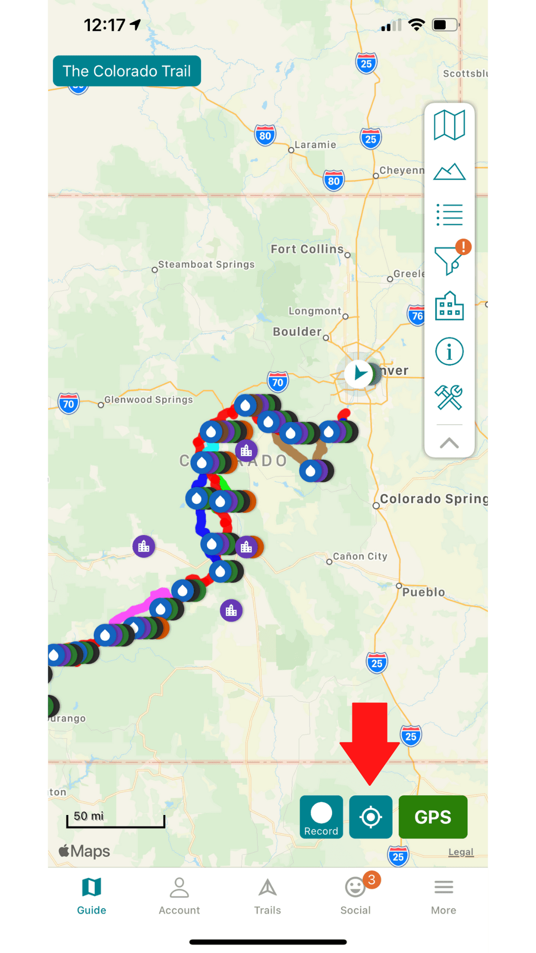
2. Tap on your “current location” button
3. Tap on your current location pop-up
4. Tap on “Send a Check-in” (Your phone must have cell service or be connected to wifi for the check-in to send)
OPTION 3:
1. Tap on the account tab on the bottom of your screen
2. Scroll down on your profile to the “Social” section
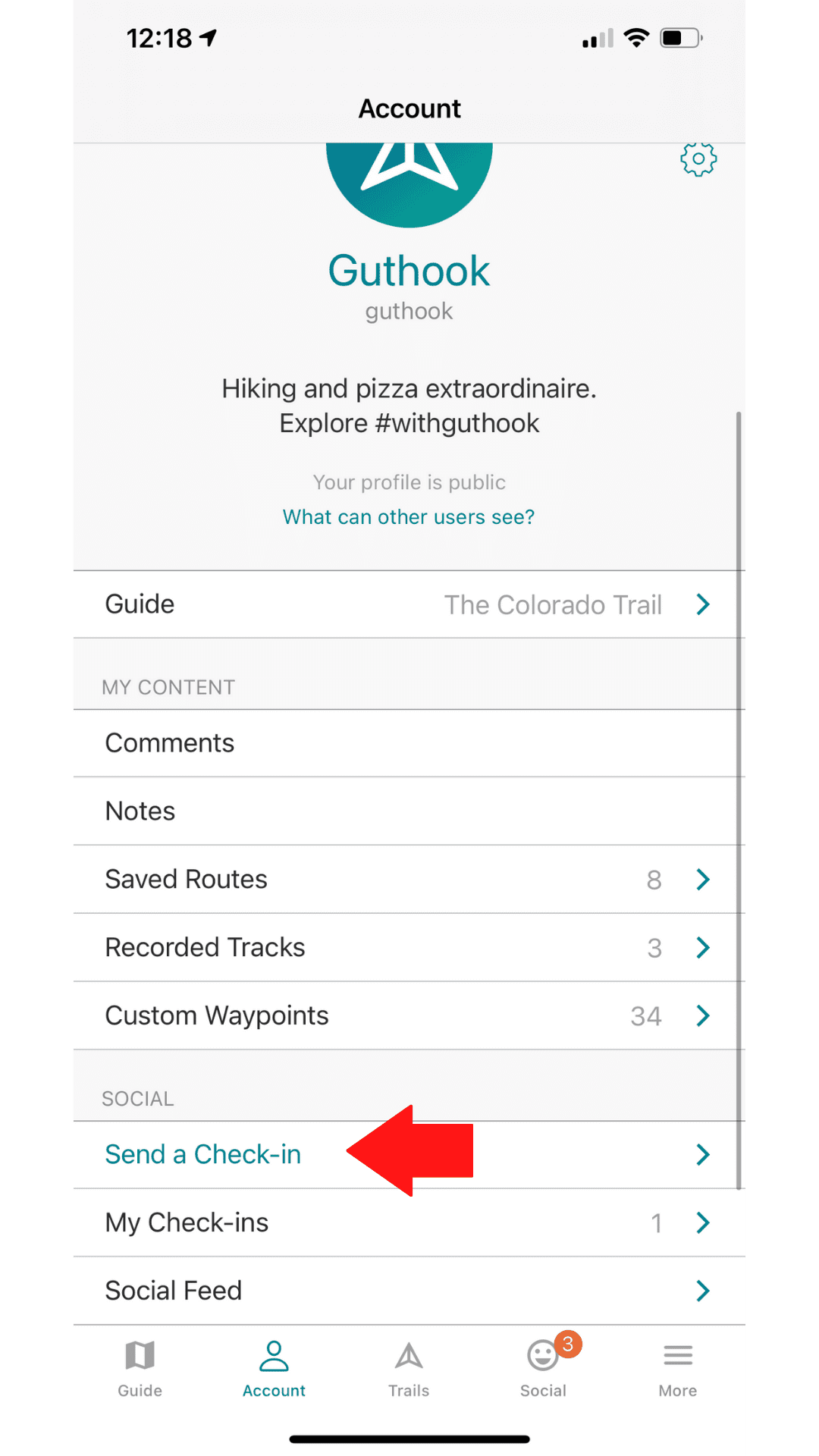
3. Tap on “Send a check-in” (Your phone must have cell service or be connected to wifi for the check-in to send)
Want to keep up with all that’s going on at Atlas Guides? Sign up for our newsletter!
Read more!
Check out more “Tech on the Trail” posts!
Download our popular hiking and biking guides!
Trail guides that get you to places you’ve dreamed of.
As the makers of Guthook Guides, Bikepacking Guides, and Cyclewayz, we help you navigate the most popular trails around the world on your smartphone. Our hiking guides and biking guides work completely offline. Let Guthook guide your next adventure!
Showers Lake Vista, Tahoe Rim Trail
Photo courtesy of the Tahoe Rim Trail Association
Showers Lake Vista, Tahoe Rim Trail
Photo courtesy of the Tahoe Rim Trail Association
Trail guides that get you to places you’ve dreamed of.
As the makers of Guthook Guides, Bikepacking Guides, and Cyclewayz, we help you navigate the most popular trails around the world on your smartphone. Our hiking guides and biking guides work completely offline. Let Guthook guide your next adventure!
Download our popular hiking and biking guides!
About the Author
Natalie McMillan
Natalie grew up hiking in Arizona where she fell in love with the outdoors. Her favorite hikes are to Havasu Falls in the Grand Canyon and Angel’s Landing in Zion National Park, UT. She loves taking pictures of people, places, and nature, which might explain why she has almost 47,000 photos currently residing on her phone. She takes care of all things related to social media and marketing and recently moved to Denver, CO from Flagstaff, AZ. You may find her frolicking around the trails and mountains of Colorado, or exploring the new city she gets to call home.
My Trail Story by Mindy
Planning an adventure? Check out our popular trail guides! 4.8 stars (17K+ ratings)
Photo by Mindy Bell
My Trail Story featuring Mindy Bell
Mindy Bell shares her experiences exploring England as she hiked on the Cotswold Way, Coast to Coast, and Hadrian's Wall Path.
Natalie McMillan My Trail Story 01/14/2020
Natalie McMillan
My Trail Story
01/14/2020
Staying on the trail with Guthook Guides
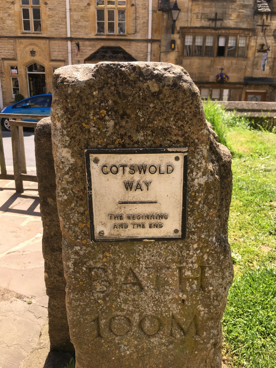
My good friends at Atlas Guides in Flagstaff design and code the “go-to” apps for staying on the trail while hiking – a challenge for me at times! They worked with the Trailblazer crew in Great Britain to develop a series of British hikes that I eagerly downloaded. I hiked sections of three different trails, while based out of enchanting cottages with lovely hosts. I deemed it “reconnaissance” hiking since I only did a few sections of each trail – but it was great to see different parts of England as well as hike the unique trails.
First up was the Cotswold Way. This trail begins in the most charming town of Chipping Campden – near the 14th century Woolstaplers Hall (now a museum). For those of you not up on woolly lingo, a wool-stapler buys wool from the producer, sorts and grades it, and sells it to manufacturers. The Cotswolds were a key center of the wool industry and I never walked a section of the trail that didn’t also include sheep. 🙂
The Cotswold Way also has loads of archeology – including the Crickley Site that shows occupation as early as 3,700 BC by some of the first Neolithic people in Britain. Another Neolithic site along the Cotswold Way is the Belas Knap Long Barrow. Excavations in the 1860’s found remains from 38 humans in the four chambers and behind the portal.
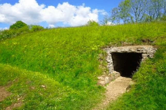
Photo by Mindy Bell

Photo by Mindy Bell
Each section I did was fantastic and my hubby and I also went out on a boat trip to an offshore island with PUFFINS! Not to mention diving GANNETS! Oh, and RAZORBILLS! It was glorious.
The strangest section of the Cotswold Way goes by the Cleeve Hill golf course. Cleeve Hill is a large common area – and during the spring and summer grazing sheep are allowed on the course! I got lost on the course (it all looked the same to me) and thankfully the app brought me back to a nature reserve – a much less homogenous landscape!
From the bucolic Cotswolds, we headed to Pembrokeshire. Several of my friends had just walked the full 186-mile Pembrokeshire Coast Path and raved about it. Though it wasn’t yet on the Guthook Guides app, I figured if I stayed close to the coast, but didn’t go over the cliffs, I would be fine. Each section I did was fantastic and my hubby and I also went out on a boat trip to an offshore island with PUFFINS! Not to mention diving GANNETS! Oh, and RAZORBILLS! It was glorious.
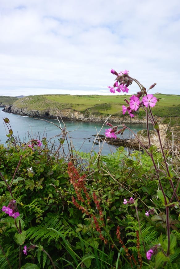
Photo by Mindy Bell
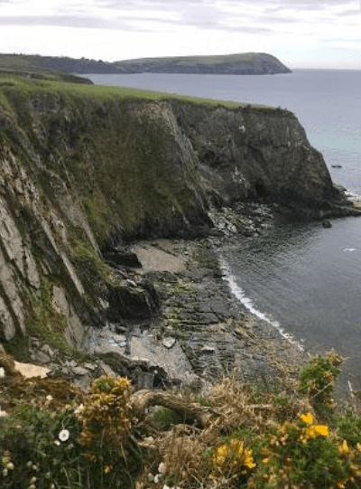
Photo by Mindy Bell
Next up was the Lake District where I hoped to hike part of the Wainwright Coast-to-Coast Trail. This 182-mile track, created by British hiker extraordinaire Alfred Wainwright, crosses three National Parks; the Lake District, Yorkshire Dales, and North York Moors. It is not well sign-posted so having the Guthook Guides app will likely save you extra hours of hiking. We connected with the trail near Patterdale, but didn’t hike very far. The fog limited our visibility to almost zero as we climbed, so we hung out in the lowlands with the sheep. I researched why we see so many painted sheep and got two answers – one is just identification of your sheep from your neighbors, and the other is to determine which ewes have mated – the ram is loaded up with a sack of dye and deposits it during mounting so the farmer can tell which ewes have been impregnated. The things I’m learning…
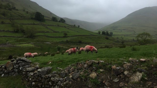
Photo by Mindy Bell
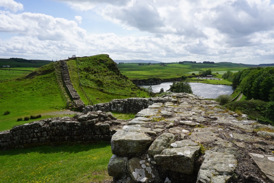
My final England hiking goal was the 84-mile Hadrian’s Wall Path, steeped in the history of the Roman Empire’s northern boundary. While trail guides tend to start the hike from the east, the app has a slick feature where you can change the direction you are hiking so you don’t have to read the guide backwards, no matter where you start or which direction you go.
I first toured the Tullie House Museum in Carlisle, near the west end, to learn more about the Roman history of this area. The museum had an entertaining and educational animated film where I learned that the wall was begun in AD 122 under Emperor Hadrian to separate the Roman Empire from the barbarians (Scots!) to the north. The history is interesting and I’d love to do the entire walk, reading more about the history as I went along. You can’t see much of the wall near Carlisle, but it is another charming town, and I enjoyed walking along the river and parks.
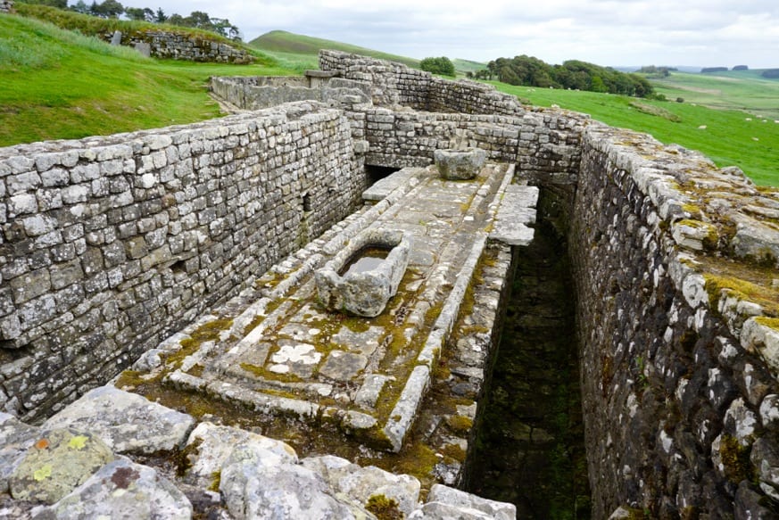
Photo by Mindy Bell
My husband and I drove to Housesteads Fort, the best-preserved of the 16 forts along the wall. We toured the fort and you can see my favorite part above! Then he dropped me off at Cawfields, Castlemile 42, and I hiked along miles of solid wall until I found him at the Twice Brewed Inn in the town of Once Brewed – or something confusing like that!
Photo by Mindy Bell
All said, I loved the hikes I did in England and want to do more!
Want to keep up with all that’s going on at Atlas Guides? Sign up for our newsletter!
Read more!
Check out some related blog posts!
Get our trail guide for this area!
Trailblazer
Our collaboration with Trailblazer guides includes hiking guides for the South Downs Way, Wainwright’s Coast to Coast, West Highland Way, Hadrian’s Wall Path, The Ridgeway, and Costwold Way.
500+ miles $24.99 full guide
England, South Downs Way
Photo courtesy of Trailblazer Guides
England, South Downs Way
Photo courtesy of Trailblazer Guides
Trailblazer
Our collaboration with Trailblazer guides includes hiking guides for the South Downs Way, Wainwright’s Coast to Coast, West Highland Way, Hadrian’s Wall Path, The Ridgeway, and Costwold Way.
500+ miles
$24.99 full guide
Get our trail guide for this area!
About the Author
Natalie McMillan
Natalie grew up hiking in Arizona where she fell in love with the outdoors. Her favorite hikes are to Havasu Falls in the Grand Canyon and Angel’s Landing in Zion National Park, UT. She loves taking pictures of people, places, and nature, which might explain why she has almost 47,000 photos currently residing on her phone. She takes care of all things related to social media and marketing and recently moved to Denver, CO from Flagstaff, AZ. You may find her frolicking around the trails and mountains of Colorado, or exploring the new city she gets to call home.
My Trail Story by Little Skittle
Planning an adventure? Check out our popular trail guides! 4.8 stars (17K+ ratings)
Photo by Becca Bergstrom
My Trail Story featuring Little Skittle
Becca Bergstrom, a.k.a. Little Skittle, reminds us that we all start somewhere and offers encouragement to anyone thinking of hiking in 2020.
Natalie McMillan My Trail Story 01/09/2020
Natalie McMillan
My Trail Story
01/09/2020
We All Start Somewhere
Let’s play two truths and a lie. One, my eyesight is so bad I can’t see past my outstretched fingertips without my glasses or contacts. Two, prior to hiking the Pacific Crest Trail, I never once spent a night alone camped in the backcountry. Three, I got a killer deal on a pair of Five Ten climbing shoes last Christmas, but they’ve yet to see the light of a climbing gym.
Photo by Becca Bergstrom
Can you guess which is the lie? If you guessed one or three, you’re wrong. I know, I know, you’re probably more shocked by the truth behind the third statement than the lie behind the second.
The new year meant I was about to take on my biggest dream and the greatest adventure I could ever imagine.
Before we start in on the lie, let me say that I had every intention of giving climbing a fair try. It’s just that as soon as we celebrated bringing in the new year, my obsession with the PCT grew tenfold so anything non-PCT related became a waste of time that could be better spent planning and preparing. The new year meant I was about to take on my biggest dream and the greatest adventure I could ever imagine. I wasn’t going to risk injuring myself before this incredible opportunity so taking on a new hobby could wait, especially such a physical one.
Photo by Becca Bergstrom
Shall we move onto the lie? I’ll preface it with this: I think it’s going to surprise many of you that the lie isn’t too far from the actual truth. Here goes; I only camped in the backcountry once prior to the PCT and it was only for one night. I picked a day in early June of 2017, before the summer rush of backpackers flooded all the popular spots.
I dug out my 42L Gregory Maya and all the other introductory backpacking essentials I’d been accumulating and storing in my closet for the last 6 months and loaded up the car for a solo night at Goat Lake in the North Cascades.
“I sipped whisky from my flask and watched the stars dance across the night sky before falling sound asleep.”
It went off without a hitch; the hike itself was pleasant enough with my fully loaded pack, I somehow had the lake all to myself and the weather was perfect for leaving the rain fly off my tent. I sipped whisky from my flask and watched the stars dance across the night sky before falling sound asleep. In the morning, I took my time watching the sun light up the lake basin while I ate breakfast. Shortly after, I packed up camp and began my hike back to the trailhead.
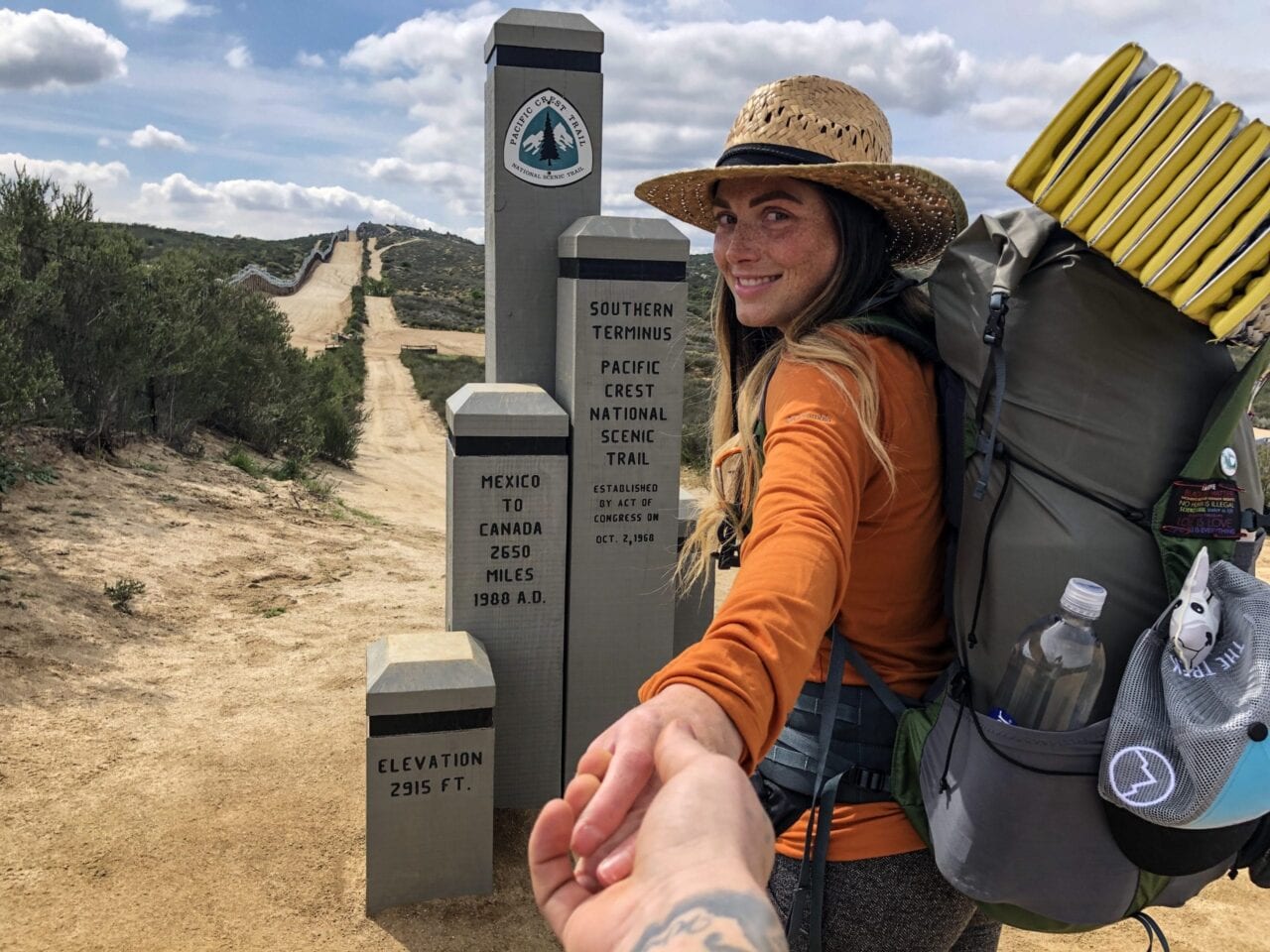
Photo by Becca Bergstrom
Fast forward to April 3, 2019. It’s just after 3pm and I’m taking a video of my boyfriend and I walking away from the monument at the PCT’s Southern Terminus, but in different directions; he, toward the rental car that would take him back to the San Diego airport, and me, heading North towards Canada. I turn the camera on myself to capture my emotional yet exciting first steps on the PCT. There isn’t another hiker in sight, which is how I planned it. Rumor has it that the monument can be very busy from sunrise until just after lunch with tourists, hikers, etc. so I wanted to do what I could to avoid the crowds. My pace is slow. I take my time soaking in all my “firsts,” like coming across my first water source and delving into my food bag for my first snack stop. Afternoon turns to evening and every campsite I come across is somehow already full. Finally, only 8.5 miles from the terminus, I find a random, right-along-trail spot that was both flat-ish enough and big enough for me to pitch my Zpacks Duplex tent. I toss my pack inside just as the sun dips below the horizon, painting the desert sky with the most beautiful blues and vibrant purples I’ve ever seen.
Here’s one more truth: you don’t NEED any experience to hike the PCT. That one and only overnighter was CUSHY in comparison. I think it’s fair to say that not a single moment of it prepared me in any way for the 135 days I spent walking from Mexico to Canada. Furthermore, I met several people along the trail who had even less experience than I did, yet they also dreamt of discovering what this trail could provide; what better way to learn how to backpack than to completely immerse yourself in the dirtbag, hiker trash lifestyle. One of these people belonged to my tramily. He was from Liverpool (i.e. he had zero experience). After a heavy night of drinking, he woke in the morning to find his browser history full of PCT videos on YouTube and an email from Amazon confirming his purchase of a Six Moons Design tent. Just a few months later he found himself at the Southern Terminus, ready to see what the hype was all about.
Photo by Becca Bergstrom
Photo by Becca Bergstrom
So for anyone with 2020 permits or dreams of other long-distance trails with hesitations regarding their experience level or lack of, remember that we all start somewhere and that somewhere can be humbling and sometimes comical, but also inspiring and admirable. Don’t be afraid to admit you’re new to the game or unfamiliar with something, even if it’s the very gear you brought. Your voice has the power to bring a surge of courage, confidence and also a sense of community to those who feel the same.
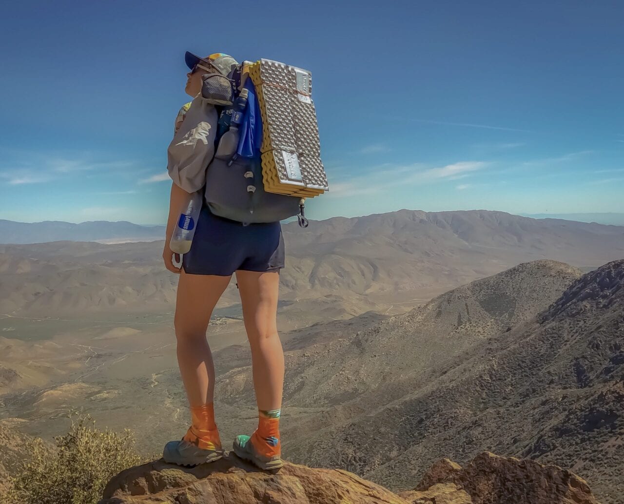
Photo by Becca Bergstrom
Want to keep up with all that’s going on at Atlas Guides? Sign up for our newsletter!
Read more!
Check out some related blog posts!
Get our trail guide for this area!
Pacific Crest Trail
The Pacific Crest Trail is an epic journey of three states and over 2600 miles. Its path travels from the US border with Mexico to the northern border with Canada.
2650 mi (4260 km) $29.99 full guide
Washington, Pacific Crest Trail
Photo by Justin Helmkamp
Washington, Pacific Crest Trail
Photo by Justin Helmkamp
Pacific Crest Trail
The Pacific Crest Trail is an epic journey of three states and over 2600 miles. Its path travels from the US border with Mexico to the northern border with Canada.
2650 mi (4260 km)
$29.99 full guide
Get our trail guide for this area!
About the Author
Natalie McMillan
Natalie grew up hiking in Arizona where she fell in love with the outdoors. Her favorite hikes are to Havasu Falls in the Grand Canyon and Angel’s Landing in Zion National Park, UT. She loves taking pictures of people, places, and nature, which might explain why she has almost 47,000 photos currently residing on her phone. She takes care of all things related to social media and marketing and recently moved to Denver, CO from Flagstaff, AZ. You may find her frolicking around the trails and mountains of Colorado, or exploring the new city she gets to call home.
8 Ways to Make Coffee While Thru-Hiking or Camping
Planning an adventure? Check out our popular trail guides! 4.8 stars (17K+ ratings)
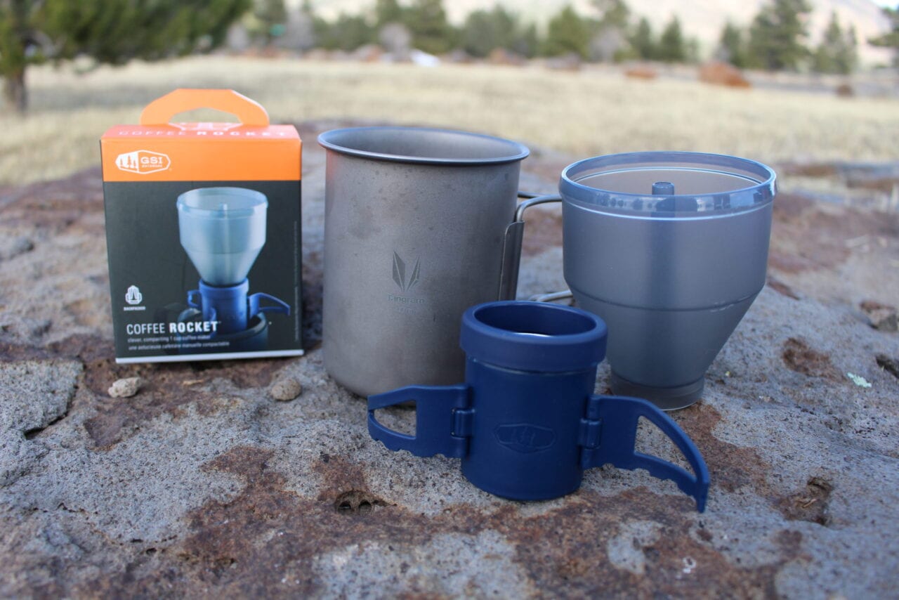
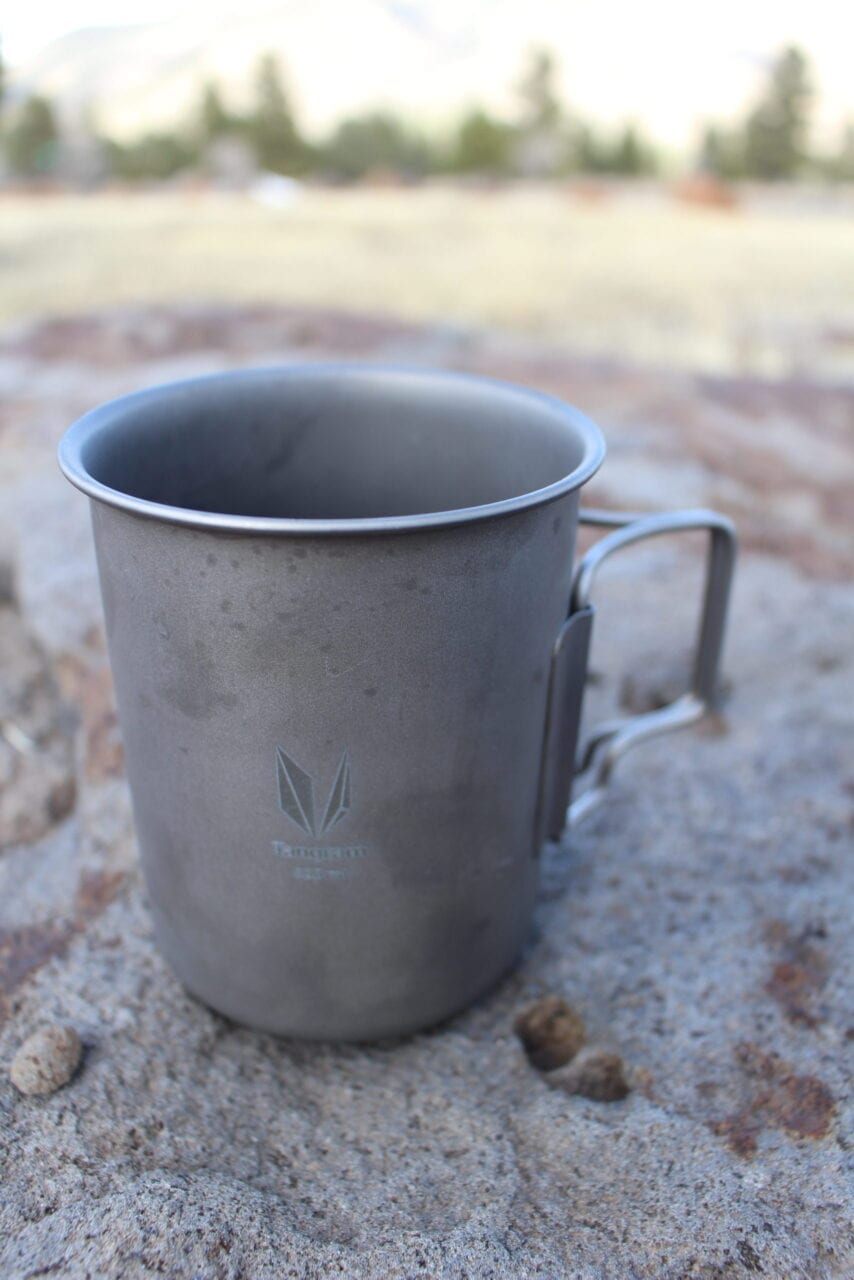
GSI Outdoors Coffee Rocket Maker
Photo by Natalie McMillan
8 Ways to Make Coffee While Thru-Hiking or Camping
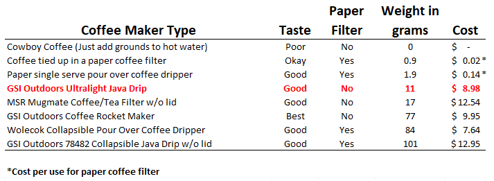
With a little planning it is possible to enjoy a good cup of coffee in the outdoors. We tested eight different ways for making coffee each with varying taste, cost, and weight. The best method for you will depend on your individual needs.
Paul Bodnar Tech on the Trail 12/13/2019
Paul Bodnar
Tech on the Trail
12/13/2019
We researched a variety of ways to make coffee while you’re backpacking or camping. Each method had its pluses and minuses, but we think you’ll find something here that works for you!
Preferred instant coffee? Check out our post about instant coffee in the backcountry: Instant Coffee on the Trail
We purchased all items and were not solicited to review any item in this blog post.
1. Cowboy Coffee
Yay: This is the easiest, most lightweight way to make coffee.
Nay: It doesn’t taste very good; requires two containers if you decant; messy to pack out used grounds
Directions: Heat up water to desired temperature and add ground coffee to taste. Let it sit for 2 to 4 minutes — any longer and you will extract the bitterness from the coffee. Drink it straight or decant to remove most of the coffee grounds. In our test we transferred the coffee to a mug to reduce the coffee grounds and it helped a lot.
Taste : This was the worst tasting coffee when compared to all the other methods. Even after decanting a lot of grounds were suspended in the coffee. This gave the coffee a grainy texture which wasn’t ideal.
Summary : Making cowboy coffee requires no equipment but makes a poor quality cup of coffee. For backpacking you will need a plan to responsibly pack out the loose, used grounds.
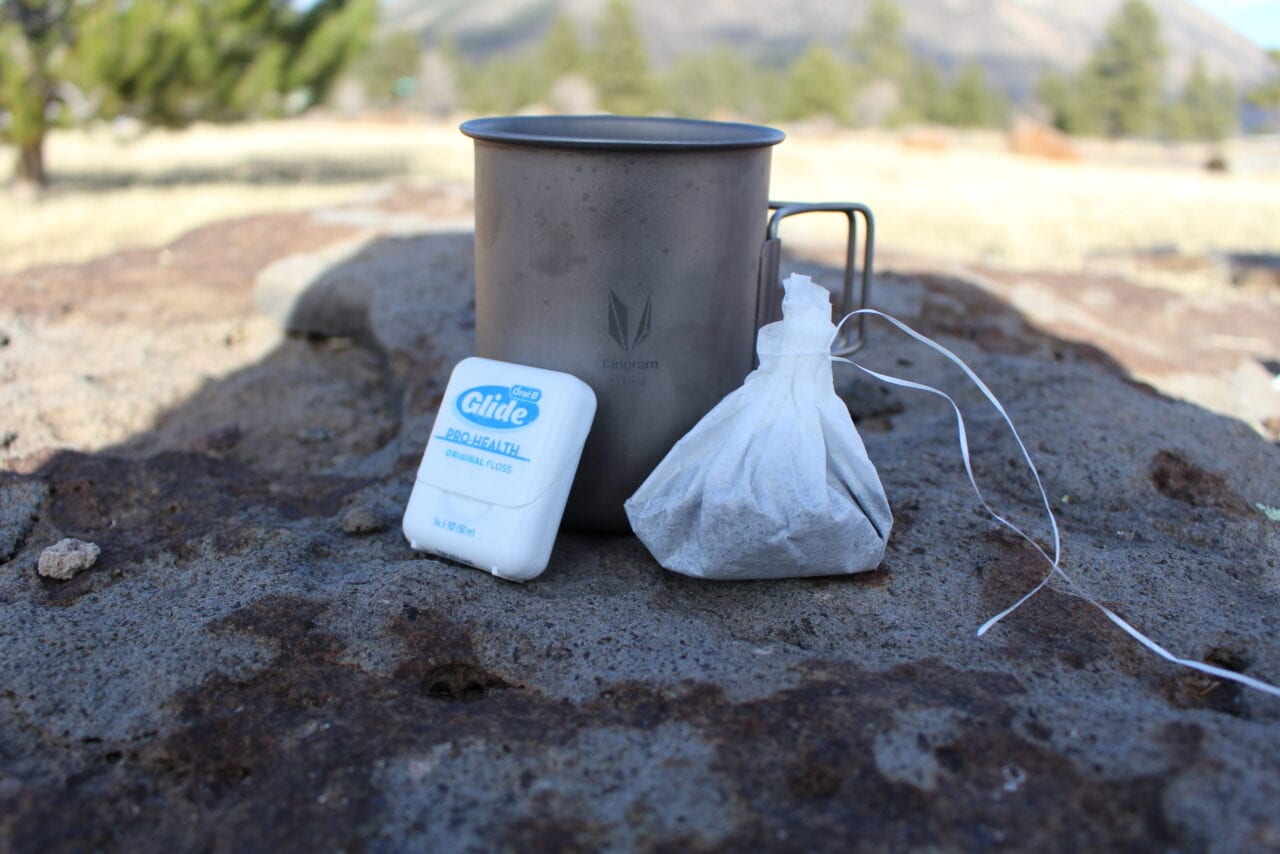
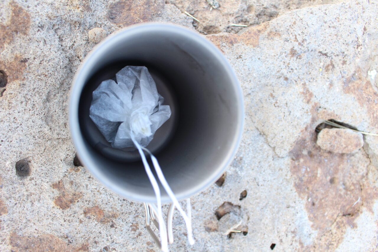
2. DIY Coffee Bag
Yay: This is one of the easiest, most lightweight, and affordable ways to make a cup of coffee; easy to pack out waste.
Nay: It has an odd flavor from the paper.
Directions: Place ground coffee in a paper coffee filter and then tie a knot using unflavored dental floss to seal the coffee inside. Heat up water to desired brewing temperature and then drop the bag into the cup or pot. Leave the bag in the cup for 2-4+ minutes, depending on how strong you like your coffee.
Taste: This was okay tasting coffee. But you can taste the coffee filter.
Summary: This makes an okay-tasting cup of coffee that is easy to make at a very low cost. You can easily pack out your waste by simply squeezing out the bag and putting it in your trash bag.
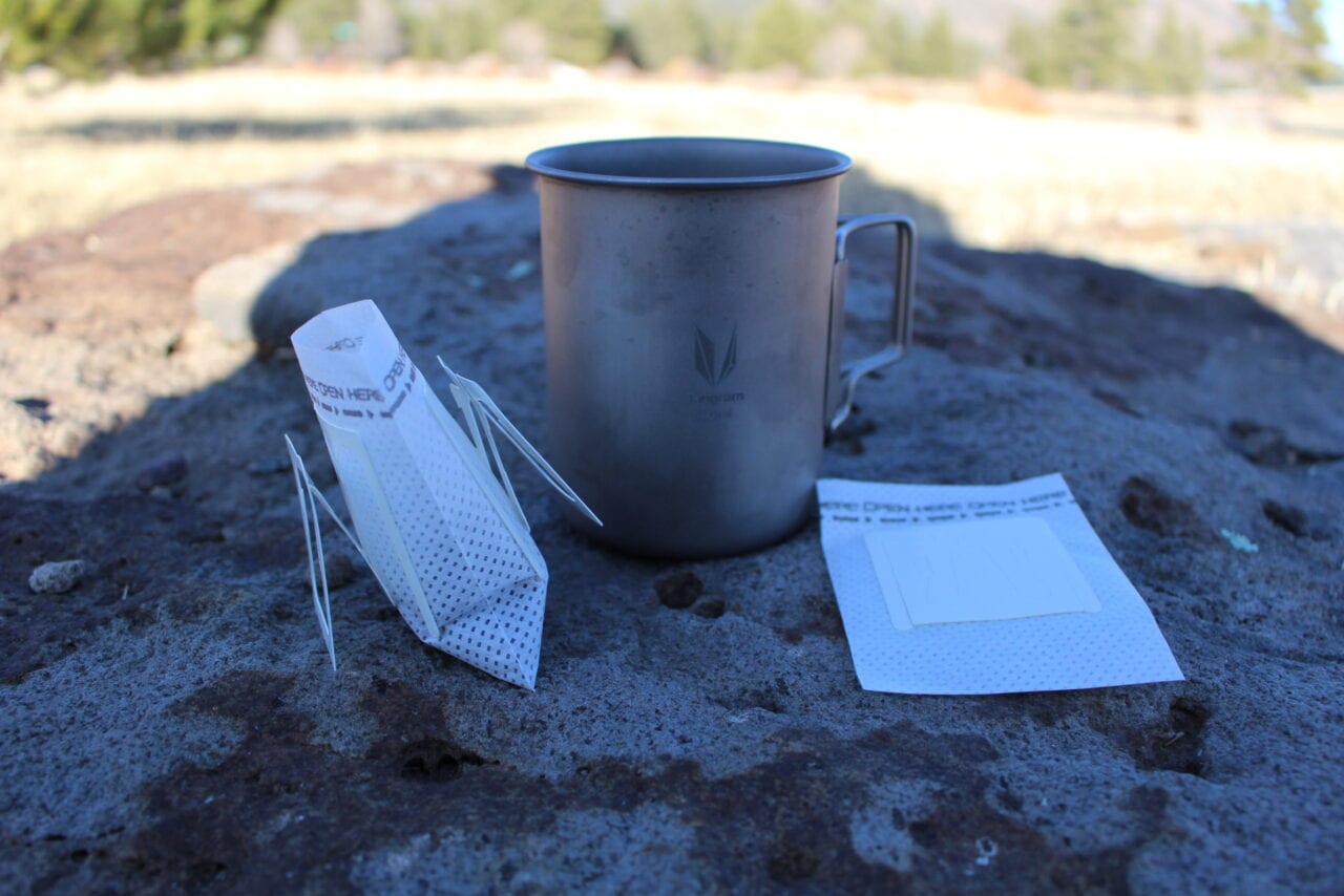
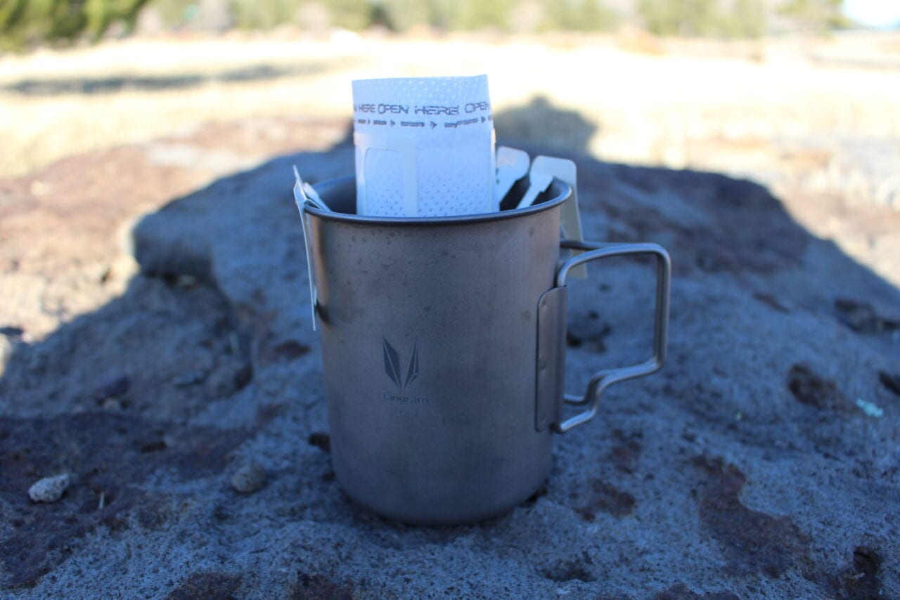
3. Single Serve Paper Pour Over Filter
Yay: This is one of the most convenient ways to make a decent-tasting cup of coffee and easy to pack out your waste.
Nay: You can taste the paper.
Directions: Place ground coffee in the single serve paper filter. Slowly pour heated water into the coffee filter and, presto! — you have a good-tasting cup of coffee.
Taste: This makes a good-tasting cup of coffee, but we did taste a hint of paper.
Summary: This makes a decent cup of coffee that is easy to make and pack out. The filters are lightweight, but come with a per-use cost that may not appeal to long-distance backpackers.
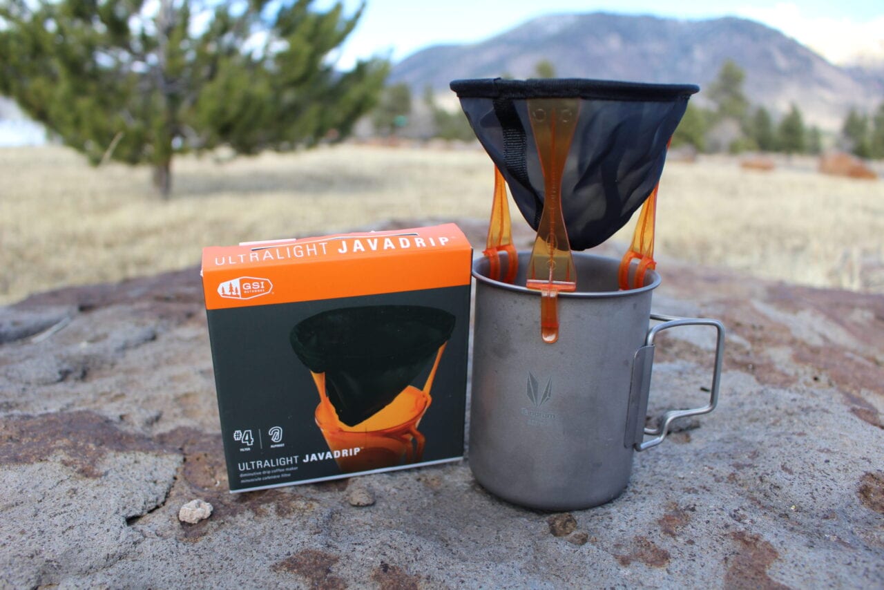
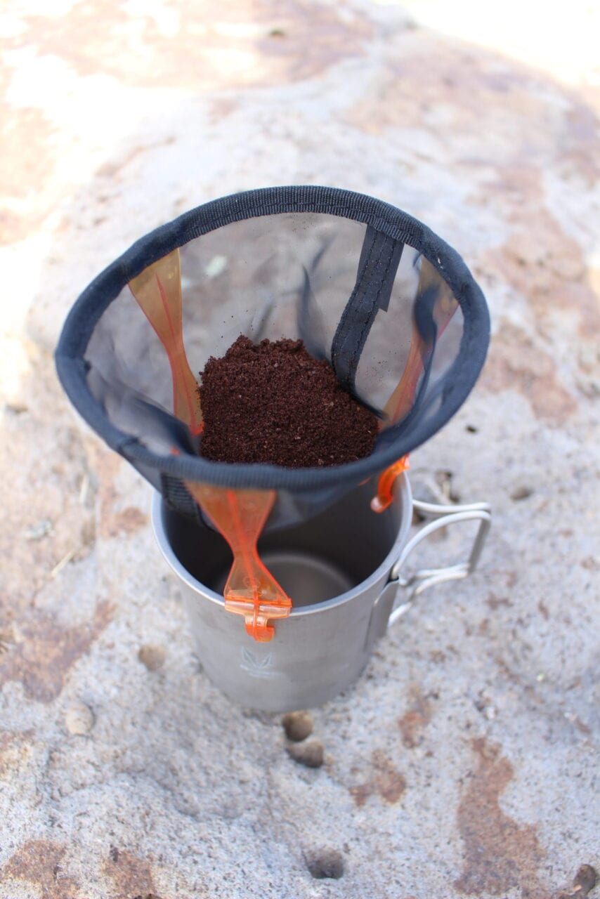
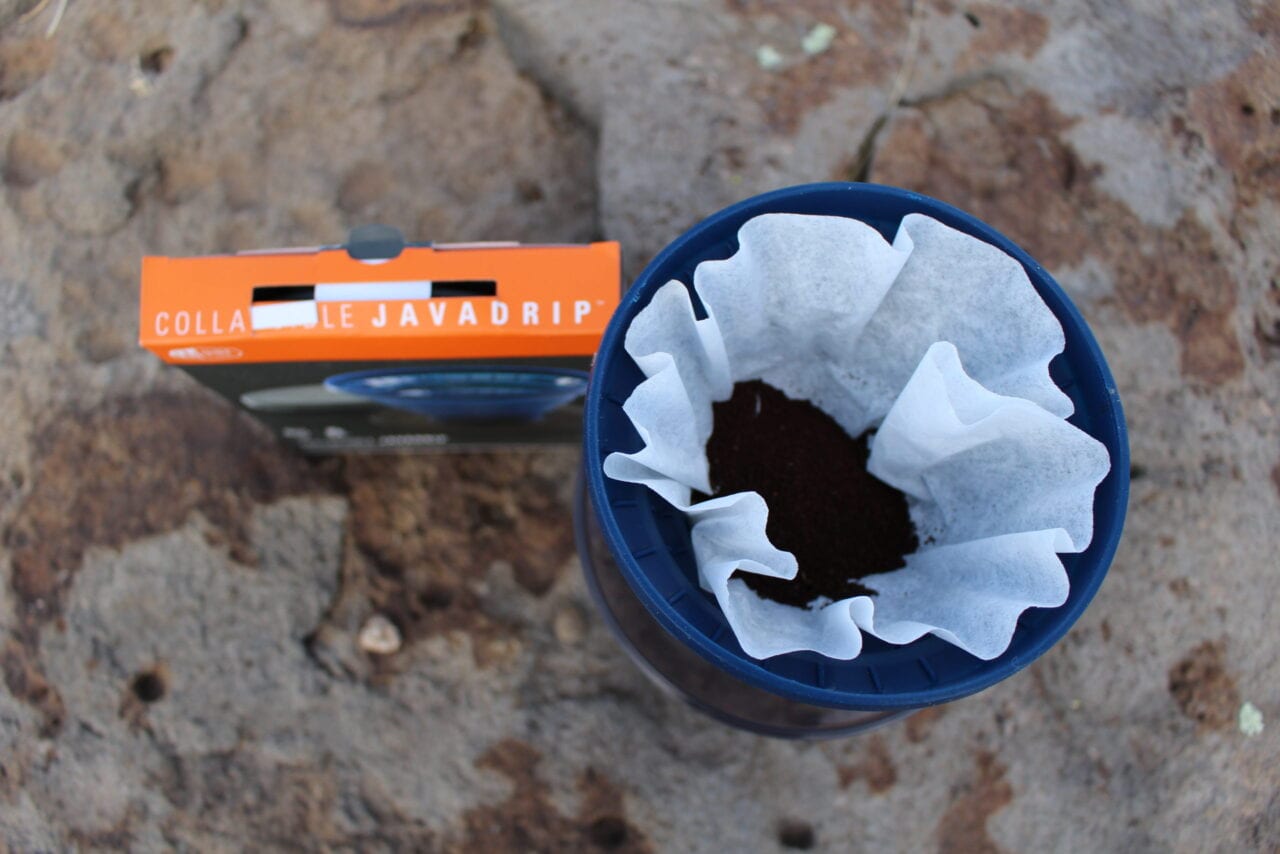
4. GSI Outdoors Ultralight Java Drip
Yay: This makes a very good light cup of coffee; doesn’t require a single use paper filter; lightweight; easy to pack out waste.
Nay: Unless you are very careful, it may not make it through a long-distance backpacking trip.
Directions: Place ground coffee in the mesh basket and clip the device to the side of your coffee cup. Slowly pour hot water over the grounds.
Taste: This makes a very good, though light (due to high flow rate), cup of coffee.
Summary: This makes a good cup of coffee and has the advantage of not using disposable single use filters. The design also makes it easy to see how much water you have already poured into the cup. (Some other coffee makers block this critical view.) It is lightweight (11 grams) and collapsible, making it easy to pack away in your cooking pot. Simply squeeze the mesh and invert the basket to put used grounds into your waste container to pack out. Bonus: You can also use this to make tea by lowering the mesh into the hot water (not clipping the plastic clips to the side of the cup).
This is my favorite coffee maker for backpacking.
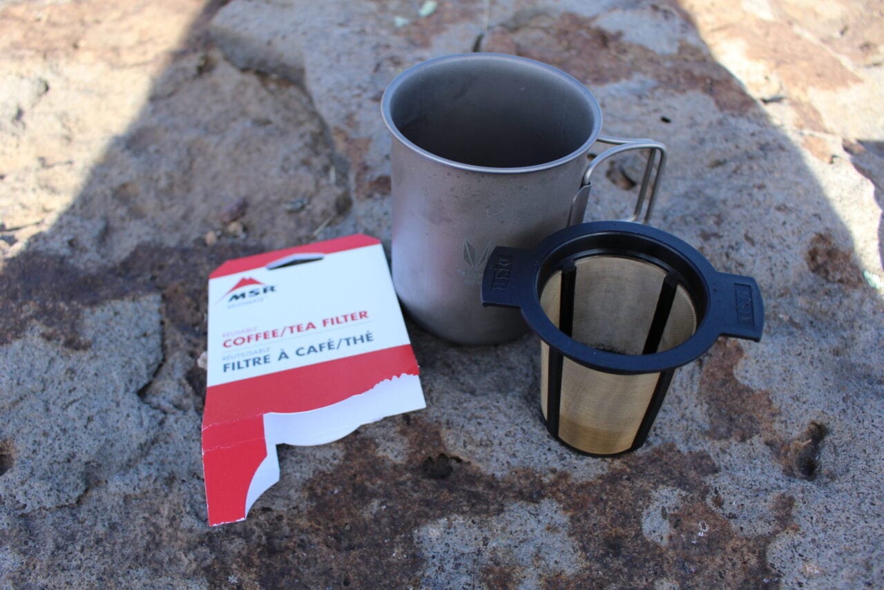
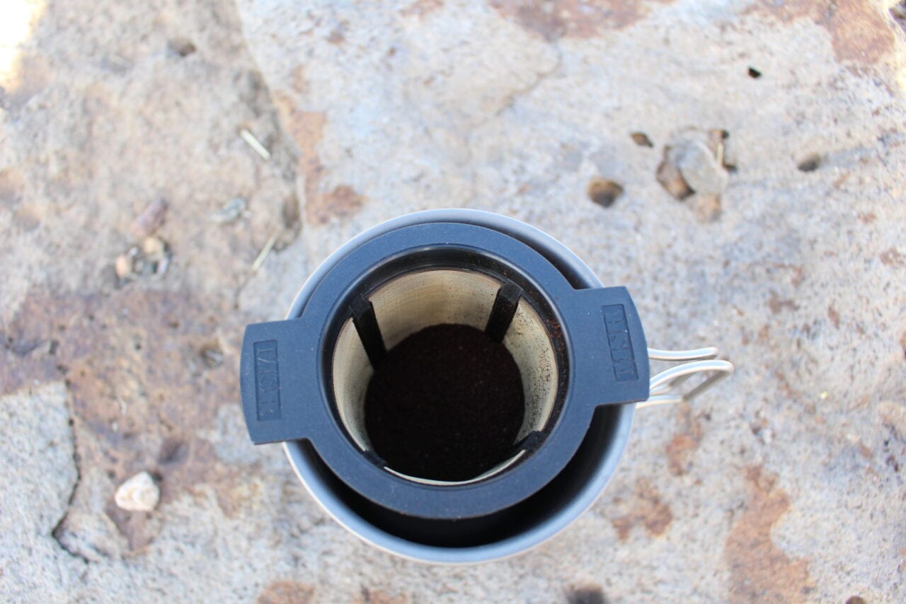
5. MSR Coffee/Tea Filter
Yay: This makes a good cup of strong coffee or tea; doesn’t require a paper filter; lightweight.
Nay: can be difficult to cleanly remove grounds from filter.
Directions: Place ground coffee in the mesh container and slowly pour hot water over the coffee. Either remove immediately or let the filter sit in the cup if you want a stronger drink (but not too long or you will get a bitter taste).
Taste: This makes very good coffee.
Summary: This is a versatile filter because you can easily make coffee or tea. It also doesn’t require single use paper filters so you’ll never have to worry about finding paper filter replacements. Leave the lid at home to save 9 grams.
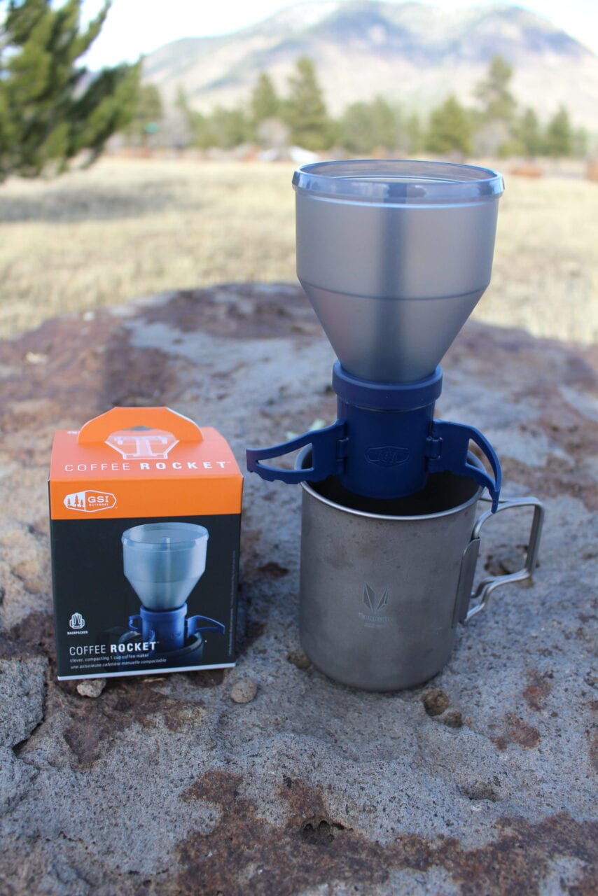
6. GSI Outdoors Coffee Rocket Maker
Yay: The GSI Outdoors Coffee Rocket Maker made the best tasting coffee.
Nay: Lots of parts and too heavy for most backpackers.
Directions: Fill the stainless steel filter with ground coffee in the blue base unit and then attach the water hopper on top. Place the entire device on top of your coffee cup. Slowly pour the hot water into the hopper.
Taste: This made the best tasting coffee out of all the methods tested due to the slow water flow rate.
Summary: This made the best tasting coffee. But its weight (77 grams), bulkiness and complexity would make most long-distance hikers squirm. The stainless steel filter has a maximum capacity of about 2 tablespoons, so you are limited to about 8 ounces of coffee per use. This coffee maker isn’t bad for overnight backpacking or camping, but not ideal for lightweight long-distance backpacking.
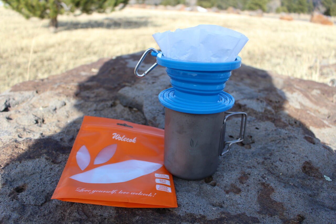
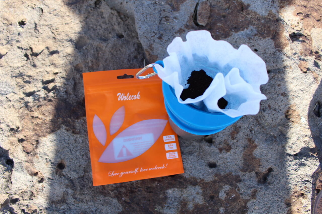
7. Wolecok Collapsible Pour Over Coffee Dripper
Yay: This makes very good coffee; it’s indestructible.
Nay: Requires a standard paper coffee filter; heavy for backpacking.
Directions: Expand the collapsible device and insert a standard paper coffee filter. Add the desired amount of ground coffee and then pour the hot water over the coffee. You have to be careful pouring water into this filter because you can’t see how much water you already added. — you can accidentally overflow your coffee cup.
Taste: This makes a good cup of coffee.
Summary: This makes good coffee due to slow water flow rate and is practically indestructible. It can handle temperatures from -40 degrees to 446 degrees Fahrenheit and the silicone is extremely flexible. The only downside is the weight (84 grams) and the fact that it requires a standard paper coffee filter. This would be a great camping coffee maker.
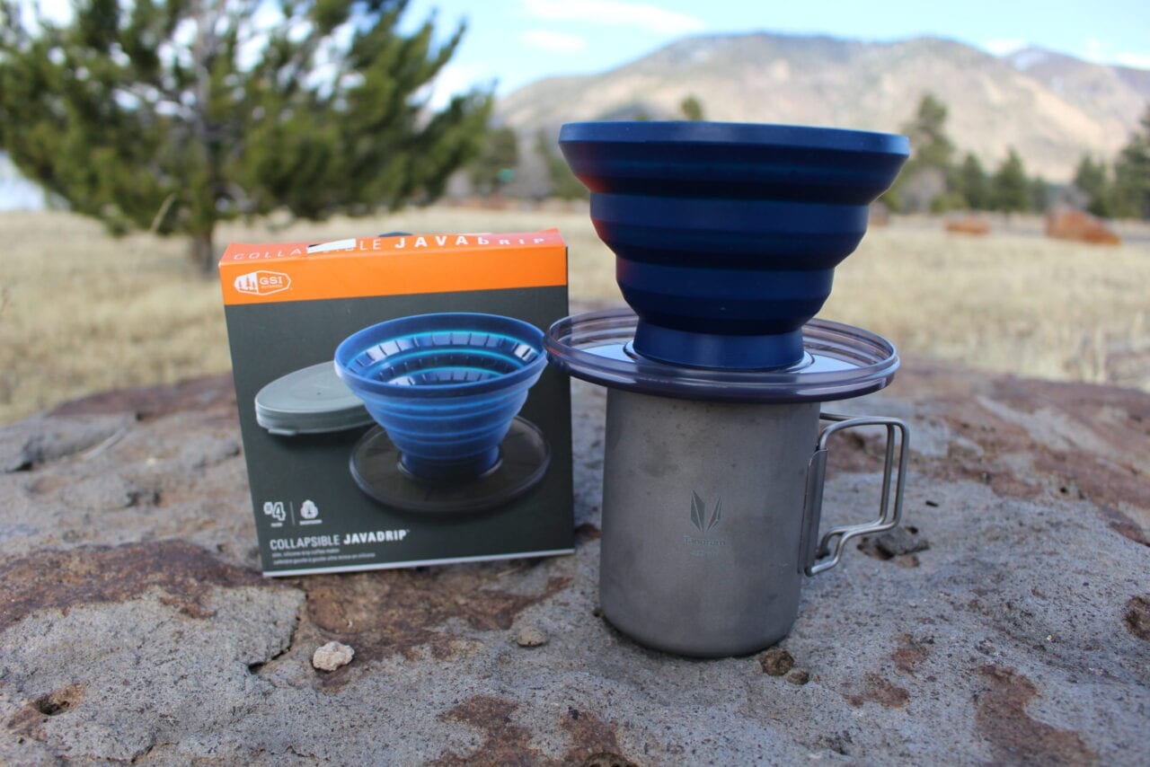
8. GSI Outdoors Collapsible Java Drip
Yay: This makes a good tasting cup of coffee
Nay: Requires a paper filter; this is the heaviest coffee maker tested.
Directions: Expand the collapsible device and insert a standard paper coffee filter into the coffee maker. Add the desired amount of ground coffee to the basket and then slowly pour hot water over the coffee. You have to be careful pouring water into this filter because you can’t easily see through the semi transparent filter base. If you aren’t careful it is easy to add too much water and overflow your coffee cup.
Taste: This makes a good cup of coffee.
Summary: The weight (101 grams or 135 grams with the lid) of this coffee maker makes it too heavy for most backpackers. It also has a breakable plastic base. I don’t see any reason to use this filter when compared to the lighter and more affordable Wolecok coffee maker shown above.
Coffee Maker Summary
My favorite backpacking coffee maker is the GSI Outdoors Ultralight Java Drip. Why? It makes good coffee, it’s easy to use, lightweight (11 grams), easy to pack, versatile (it can make tea too), doesn’t require paper filters and it is affordable.
My favorite camping coffee maker is the Wolecok collapsible pour-over coffee dripper. Why? It’s indestructable, easy to clean, and easy to store.
Want to keep up with all that’s going on at Atlas Guides? Sign up for our newsletter!
Read more!
Check out some related blog posts!
Download our popular hiking and biking guides!
Trail guides that get you to places you’ve dreamed of.
As the makers of Guthook Guides, Bikepacking Guides, and Cyclewayz, we help you navigate the most popular trails around the world on your smartphone. Our hiking guides and biking guides work completely offline. Let Guthook guide your next adventure!
Showers Lake Vista, Tahoe Rim Trail
Photo courtesy of the Tahoe Rim Trail Association
Showers Lake Vista, Tahoe Rim Trail
Photo courtesy of the Tahoe Rim Trail Association
Trail guides that get you to places you’ve dreamed of.
As the makers of Guthook Guides, Bikepacking Guides, and Cyclewayz, we help you navigate the most popular trails around the world on your smartphone. Our hiking guides and biking guides work completely offline. Let Guthook guide your next adventure!
Download our popular hiking and biking guides!
About the Author

Paul Bodnar
Paul has always liked hiking and thru-hiked the Pacific Crest Trail in 1997 after college. After years of working in chemistry, he wanted to create a career involving the outdoors, so he hiked the Pacific Crest Trail again in 2010 to do research for his guide book Pocket PCT. He realized that creating a smartphone app for navigating the outdoors would make it easier to keep the data current and provide a better way to navigate. While hiking with Ryan (aka Guthook) in 2010, they decided to work together to create the first comprehensive smartphone guide for the Pacific Crest Trail. Now with the help of a team of great people they have created over 50 guides for trails around the world.
My Trail Story by Early Bird
Planning an adventure? Check out our popular trail guides! 4.8 stars (17K+ ratings)
Photo provided by Deserrae Potts
My Trail Story featuring Early Bird
Deserrae Potts, a.k.a Early Bird, shares the story of how she went from a completely broke student and inexperienced backpacker to a thru hiker in one year.
Fatima Peña My Trail Story 11/15/2019
Fatima Peña
My Trail Story
11/15/2019
How I Went From Zero Experience and No Gear to a Thru Hiker in One Year
Trail Name: Early Bird
Trail: Appalachian Trail in 2019
Age: 21 years old
Hi my name is Deserrae, trail name “Early Bird,” and I thru-hiked the Appalachian Trail in 2019 immediately after I graduated college. This is the story of how I went from a completely broke student and inexperienced backpacker to a thru hiker in one year!
Photo provided by Deserrae Potts
My whole life, I have always been strongly drawn to spending time outdoors doing physical activity. It was common for me to regularly be frustrated that I didn’t have any skills, knowledge, gear, or even a partner to go and do the activities I had such a strong desire for. I got into climbing at the indoor campus gym while I was in college, but I was always frustrated with the fact that I didn’t have a solid partner or the money for any gear to get outside. I always found myself relying on other people to take me out and teach me skills, or even lead a route for me that I didn’t feel strong enough to complete. I couldn’t justify investing the very little money I had in the sport when my equipment would have a short expiration date and I still didn’t have a solid partner who would commit to actually using the gear with me. It felt like I was at a dead end so I found myself looking for something I could do on my own.
Searching for my own thing, I knew that backpacking was something I had always wanted to do. I followed a girl on Instagram who thru hiked the Pacific Crest Trail last year, and I would constantly see pictures and read stories of her cowboy camping and hiking alone. I couldn’t get over just how on earth I could ever do such a thing, but the more I saw her doing it, the more I thought I could probably do the same. I remember even reaching out to her and asking how she handled camping alone.
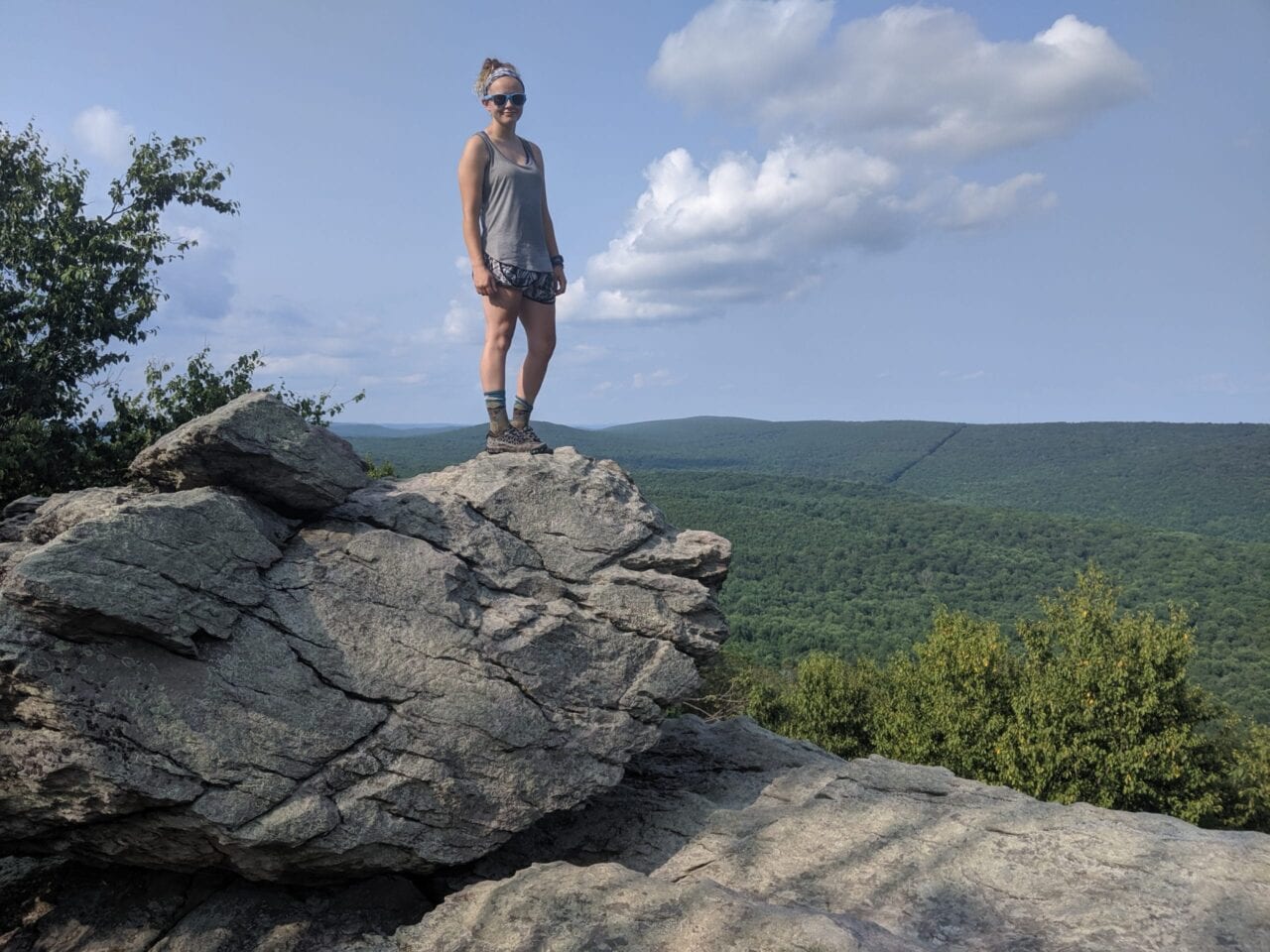
Photo provided by Deserrae Potts
Miraculously, I ended up being given a backpack and tent as a gift. Next I spent money on a sleeping bag, which seemed like a big deal to me who at the time was saving every penny I could and working like crazy to pay for my college degree. At one point I remember giving myself a $10 a week budget to do something fun, which included anything that wasn’t absolutely necessary for me to live or own. Even if I wanted to get a cup of coffee with a friend I would have to dip into the $10, and only have $7 left. As a result I’ve always been pretty careful about my decision making regarding money. To make a long story short, I absolutely did not have the funds to start backpacking, yet I still found a way. I went to yard sales all summer and I found a junky sleeping pad for only $2, but it worked for me! I saved up the funds to purchase a water filter and buy the cheapest stove and cook set sold on Amazon. Now that I felt like I had the absolute basics to get outside: a tent, backpack, sleeping bag, stove, and water filter, I just needed to find someone to go with. There was still no way I was going to go alone!
Photo provided by Deserrae Potts
I asked my friends to go with me several times but after hearing “no” and “I’m too busy” so many times I just gave up. I was so desperate I started to look for random people on Facebook to go with via the group feature, and that’s where I found “Mountain Chicks Midwest” (a group which has ceased to exist). They had a backpacking trip planned for the next weekend that worked for me. All I had to do was sign up, and show up to the relatively local location with my gear. That was it. No money involved. I definitely could not afford to pay $300 to go on a guided trip with an outdoors company like REI or the college program.
Photo provided by Deserrae Potts
I showed up to the trip with barely anything in my backpack, mostly because I didn’t own anything else to bring. I didn’t know a single person and I was the youngest one by far, being only 20 at the time. There were quite a few middle aged women, as well as a retiree. When we started hiking I was so nervous. My backpack looked considerably empty compared to everyone else’s, and they were all experienced, often going on day hikes or weekend trips. The first hill we climbed up absolutely killed me. I remember thinking that I couldn’t believe how hard backpacking was, but regardless, I was instantly in love with it.
My pack wasn’t adjusted correctly and my shoulder and neck were killing me. Too afraid to speak up in fear that I would be complaining about something else everyone wasn’t having a problem with, I didn’t say anything until we got to camp where one of the women kindly helped me learn how to adjust my pack the correct way so I wouldn’t hurt. At night I heard coyotes howling outside my tent, and I didn’t sleep at all because I was so paralyzed with fear. When the trip was over and I finally arrived home I felt more sore and beat up than I had expected. There were bruises on my hips and I was hoping I wouldn’t have to limp around for my 12 hour shift at the hospital the next day.
Photo by Deserrae Potts
After actually getting outside and doing it, I was hooked. Spending most of my life living in an Appalachian Trail state (Pennsylvania), I can’t remember not knowing the trail existed. In the back of my head I always knew it was something I wanted to do when I grew up, but I really didn’t understand or think about what it would take to actually complete it. I ended up with a job making more than I ever had (which was still close to minimum wage) and living in a place with rent cheap enough to save extra money. When I decided to graduate a year early, I realized that I would actually have funds to do what I wanted!
Photo by Deserrae Potts
I remember taking 21 credit hours, and when I wasn’t studying I was working 12 hour shifts. It was a difficult and extremely busy time, but I was determined that I would be thru hiking the trail less than a year from now. I became so obsessed with the trail that I could barely sleep. Constantly, I was praying about it, doing research, reading books, and watching videos. There were a lot of sacrifices I had to make in order to do it, but I wanted it so bad. In fact, I don’t really feel that I’ve ever worked so hard for something that I was so desperate to do in my whole life.
Photo by Deserrae Potts
Telling people what I wanted to do was scary. I was so worried that people would be disappointed that I didn’t really care about graduating college, or that I would bail out in my first week. There were several times I found myself doubting if I could really hike 2,200 miles by myself and almost didn’t even attempt it. Eventually I came to the conclusion that it doesn’t matter what other people think of my dreams and that I am the only one who would make it happen for me. Making the final commitment in my head was one of the biggest and most intimidating steps of the entire trail journey. Without that first step, I wouldn’t be sitting here writing about how I went from being a broke college student with zero experience to a thru hiker in a year.
Photo by Deserrae Potts
So if you’re thinking about thru hiking or backpacking and asking yourself how on earth you will pull it off, I’m here to let you know that where there is a will, there is a way. I promise, that whatever is stopping you has been overcome by someone else at some point and if they can do it, so can you!
(Disclaimer: At some point on my thru hike I have gone without every single one of these items listed in my absolutely necessary gear list, except for a backpack. Not that I recommend going without any of these items (except a stove), but where there is a will there is a way!)
Photo by Deserrae Potts
Want to keep up with all that’s going on at Atlas Guides? Sign up for our newsletter!
Read more!
Check out some related blog posts!
Get our trail guide for this area!
Appalachian Trail
The Appalachian Trail is one of the oldest National Scenic Trails in the US. Its path takes you from Springer Mountain in Georgia to Mt. Katahdin in Maine.
2200 mi (3540 km) $59.99 full guide
Pennsylvania, Appalachian Trail
Photo by Zoë Symon
Pennsylvania, Appalachian Trail
Photo by Zoë Symon
Appalachian Trail
The Appalachian Trail is one of the oldest National Scenic Trails in the US. Its path takes you from Springer Mountain in Georgia to Mt. Katahdin in Maine.
2200 mi (3540 km)
$59.99 full guide
Get our trail guide for this area!
About the Author

Fatima Peña
Fatima is Atlas Guides’ 2019-2020 student intern. She is an art major at Northern Arizona University.
Why is our app called Guthook?
Planning an adventure? Check out our popular trail guides! 4.8 stars (17K+ ratings)
Enough trail tools to take care of basic maintenance will fit in the side pocket of an ultralight backpack.
Photo by Ryan Linn
Why is our app called Guthook?
We’ve been asked more than a few times what the proper name of our app is. Is it “Guthooks” or “Guthook”? “Guthook’s Guide” or “Guthook Guides”? And just what is Guthook, anyway? What does it have to do with navigation for thru-hikers? Let’s find out!
Ryan Linn Inside Atlas Guides 11/07/2019
Ryan Linn
Inside Atlas Guides
11/07/2019
The best place to start this story is in the middle, when Paul and I released the first version of our app, “Guthook’s Pacific Crest Trail Guide.” That’s “Guthook’s” with a possessive apostrophe, indicating I (Guthook being my trail name) had created a guide to the Pacific Crest Trail. But Paul and I worked equally on the app, so it could just as easily have been “Tangent’s Pacific Crest Trail Guide,” (Tangent being Paul’s trail name). At the time, though, I had a 5 year-old blog called “Guthook Hikes!”, so we decided to boost the app with my name.
Guthook’s PCT Guide
That was seven years ago, though, and the name of the app has changed a few times. For a while, we had variations of “Guthook’s Guide” to various trails. Within a few years, so many hikers referred to “Guthook” as a daily part of their hike that I almost wished we had chosen a different name. My friends had been calling me Guthook since years before I hiked the Appalachian Trail, so when I heard hikers say things like “I look at Guthook all the time,” or “I checked out Guthook in my tent this morning,” I started to feel a tiny bit uncomfortable. But the ship had sailed by that point. No turning back now!
Eventually, when we combined our various trail apps into one, we decided on a simpler name. “Guthook Guides” is the official name, although if people use some variation of “Guthook,” it’s not hard to understand what they’re referring to. I find it amusing to continually hear people referring to “Guthooks,” which I guess is a plural of “Guthook,” though there’s only one of me.
And what exactly does “Guthook” mean? We get that question from time to time, too, although much less than you’d think. As I mentioned above, I’ve had the trail name since well before I began thru-hiking. The story isn’t very exciting – on a spring break trip with my college’s outing club, one of the club’s leaders decided that the freshmen needed intimidating names for our future forays into the wilderness. We were at a hunting and fishing store at the time, and the aisle stocked with various sharp tools provided a great array of names for us. Guthook, Bonesaw, and Meat Cleaver are a few that stuck.
You might wonder if it’s proper to use a name from before a thru-hike as your trail name, since you’re supposed to get your trail name on the trail. I’ve always said that anyone who claims there are rules about trail names is mistaken, though. Your trail name is whatever sticks, and what stuck for me was “Guthook.” What has stuck for the app that we’ve created is also “Guthook.”
Want to keep up with all that’s going on at Atlas Guides? Sign up for our newsletter!
Read more!
Check out some related blog posts!
Download our popular hiking and biking guides!
Trail guides that get you to places you’ve dreamed of.
As the makers of Guthook Guides, Bikepacking Guides, and Cyclewayz, we help you navigate the most popular trails around the world on your smartphone. Our hiking guides and biking guides work completely offline. Let Guthook guide your next adventure!
Showers Lake Vista, Tahoe Rim Trail
Photo courtesy of the Tahoe Rim Trail Association
Showers Lake Vista, Tahoe Rim Trail
Photo courtesy of the Tahoe Rim Trail Association
Trail guides that get you to places you’ve dreamed of.
As the makers of Guthook Guides, Bikepacking Guides, and Cyclewayz, we help you navigate the most popular trails around the world on your smartphone. Our hiking guides and biking guides work completely offline. Let Guthook guide your next adventure!
Download our popular hiking and biking guides!
About the Author

Ryan Linn
Ryan is also known as “Guthook,” which is where our apps get their name. Already an avid hiker, he hiked the Appalachian Trail, New England Trail, and Pacific Crest Trail before joining forces with Paul to create the Guthook Guides apps. Ryan handles iOS development for our apps from his office in Maine, and usually runs away to the forests and mountains throughout New England. He also volunteers with the Maine Appalachian Trail Club and the Natural Resources Council of Maine. Baxter State Park in Maine is his happy place.
My Trail Story by Chad Lubinski
Planning an adventure? Check out our popular trail guides! 4.8 stars (17K+ ratings)
Photo provided by Chad Lubinski
My Trail Story featuring Chad Lubinski
Being an outdoor enthusiast his whole life, Chad Lubinski set out on a PCT section hike to see if the long-distance hiking lifestyle was for him. He shares about his experience and what he learned being pushed out of his comfort zone.
Natalie McMillan My Trail Story 10/04/2019
Natalie McMillan
My Trail Story
10/04/2019
By: Chad Lubinski (no trail name yet)
PCT Section Hiker – 250 miles this summer
Spring 2020: 275 miles from Campo to Big Bear and possible JMT thru-hike
27 years old
I’ve been in love with the outdoors all my life. After living and graduating college in the Midwest (Go Packers!), I knew I needed something more. I packed everything I owned and made the move to Oregon. This same feeling came over me in the winter of 2018, when, after going through yet another seasonal depression (big mistake not to research how much rain Portland gets in a year!), I decided I wanted to adventure more and get out of my comfort zone by exposing myself to hikes longer than your typical weekend.
Photo provided by Chad Lubinksi
I decided to do a 100 mile section hike of the PCT in Oregon.
And… I wanted to hike it entirely solo.
Let me preface – to any thru-hiker reading this, 100 miles seems like a chip shot and I totally get that. I’m a fan of graduated practice and 100 miles was still outside my comfort zone at that point in my life. I wanted to make sure I would enjoy the long distance hiking lifestyle before going out and buying all the expensive gear I thought I should own. I also wanted to know if I’d be absolutely miserable or if I’d truly enjoy myself.
Photo by Chad Lubinksi
Back to the solo section hike.
Yes, I wanted to do everything “my way”. After watching hours and hours of YouTube videos and going on a few early backpacking trips, I figured I was dialed in. Hilariously, I only ended up downloading the Guthook app a few days before leaving as I didn’t think I would need it!
My lovely girlfriend, Karlee, dropped me off at the PCT trailhead at Willamette Pass. Ten minutes into my hike, I had already made a wrong turn and was starting to go under the ski lifts! Talk about being a rookie!
Oh Guthook, what would I do without you?!
This hike was a steep, yet enjoyable learning curve. On the first night, fate ended up bringing Salty Dog – a 68 year old hiker from North Carolina who thru-hiked the AT in 2015 and was finishing up the PCT this year – whistling into my camp at Bobby Lake. From then on, Salty and I became hiking partners for the duration of my hike. At first, I was curious to see how this would play out since my plan was to hike solo and learn everything on my own.
What happened was better than anything I could’ve anticipated.
Photo by Chad Lubinksi

Photo by Chad Lubinksi
Fast forward to day two: a dense, dark cloud of mosquitoes pleading to get into my tent, my ankle throbbing, and chafe between my thighs made me reconsider what in the hell I was actually doing after only my second day out. The doubts began swirling in my mind and the thought of completing 100 miles seemed extremely daunting, if not extremely doubtful. However, Salty’s particularly positive attitude about the situation put me at ease. We discussed the general craziness of what thru-hikers go through between our tent walls as the sun was still up (if you’ve ever been through Oregon during mosquito season, you’ll know why!). We agreed that one of the most important things a long distance hiker can own is the space in their mind to put up with suffering on a day-to-day basis, or – in Salty’s words – the ability to get “trail hardened” – letting the natural adaptation to the rigors of the trail set in before calling it quits.
My trail hardiness was tested on this hike as I experienced the gambit of conditions throughout the week – cold rain, a day of snow travel, mosquitoes, lava rocks, and heat. I saw several other hikers getting off trail early, as well as opting out of traveling through the snow that still lingered under the Three Sisters Mountains.
I started to reframe my mind around how I viewed each of the conditions I was subjected to; I began to view them as a pros vs cons. For example, it may have been rainy and miserably cold the third day, but there was no instances of running down the trail from mosquitoes, and the cold weather allowed for smaller carries of water between sources.
I was miserable well over half the time on trail, but absolutely loved it and couldn’t figure out why.
I had officially caught the bug.
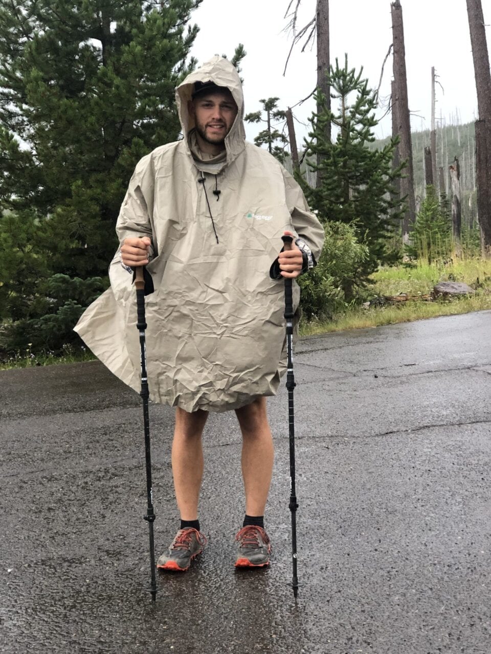
Photo by Chad Lubinksi
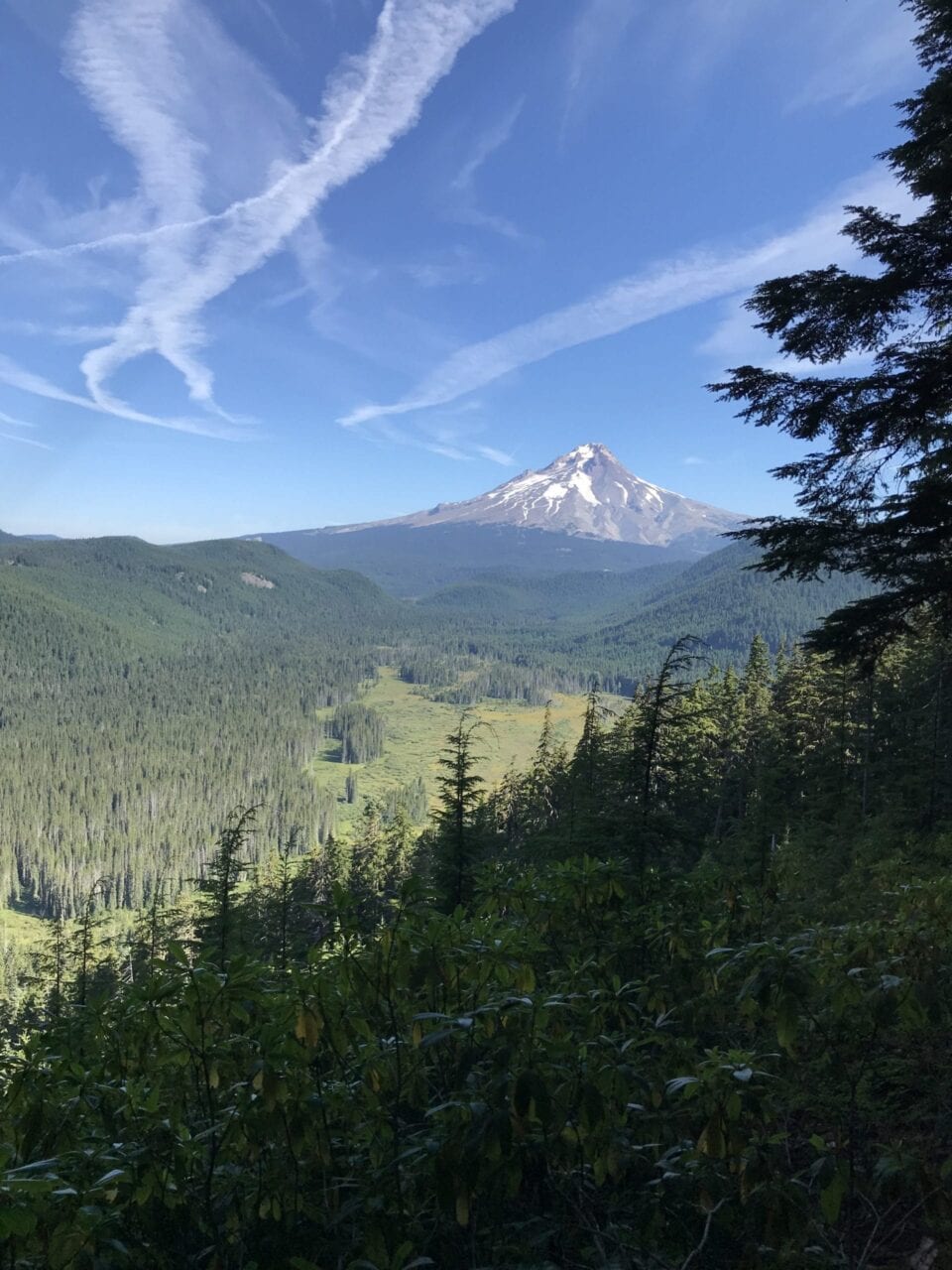
Photo by Chad Lubinksi
A month later, I used my new mindset to plan and complete my second section hike. This time I was going to do 150 miles. This time the hiking would be mostly solo with no primary mentor.
The first day I was dropped off it was pouring rain. I woke up the next day to more cold rain, fog, and wind. Salty’s mantra of “Never quit on a bad day,” and “There’s more good days than bad days on trail,” began playing on repeat in my head. For context, the weather was bad enough to make a thru-hiker I had camped with up and quit!
I was fortunate enough to be hiking during the tail end of the thru-hiking bubble. When I caught up to someone (or more like they caught up to me), you bet I was picking their brain. This meant I got to talk to many different thru-hikers about their experiences.
After eating lunch at Olallie Lake, I ran into a thru-hiker sitting next to the dusty trail. We hiked together during that warm evening for a few hours. I had expressed to him the disappointment I had with the weather at the start of my trip. His response was interesting and enlightening. He said that you have to look at obstacles like that as challenges to be overcome. Once you overcome them, you become a much better and more experienced hiker. He also told me that a trick to stay motivated for him was to challenge himself on a day-to-day basis – things such as making himself carry a minimal amount of water for X number of miles or dry camping. He said, “Otherwise, you’re just walking in the woods.”
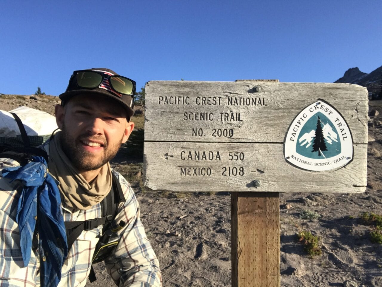
Photo by Chad Lubinksi
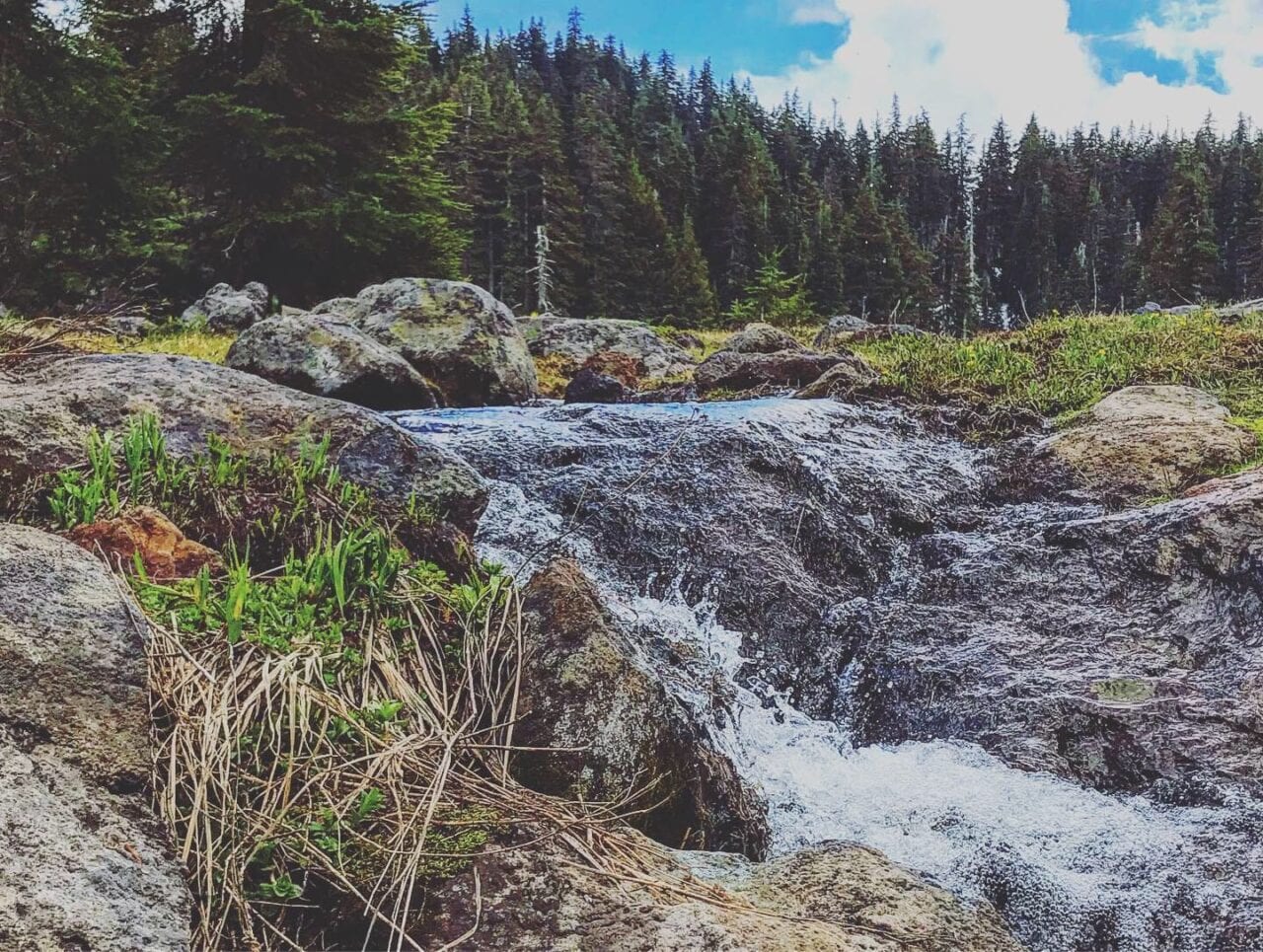
Photo by Chad Lubinksi
Each thru-hiker I met did things a little different, but the thing they had in common is that they were normal people. That’s right folks – anyone can hike a ton of miles, but the common denominator is a positive mindset, dropping the “know it all attitude” and learning from the people you meet on trail. It struck me that if I had been recording all the hikers I was informally interviewing on trail, I could’ve been the next up and coming hot podcast!
Another mindset piece I developed on this hike was the inclination to always be looking forward to small things throughout the day. This helped curb the monotony associated when hiking through boring sections (yes, the trail will get boring at times!) and allowed me to stay motivated each day. An example of this would be looking down at my watch and telling myself that I’ll allow myself to listen to music or a podcast in an hour. Looking forward to the giant distance between you and the finish line never did anyone any good.
The difference between this hike and my first was unrecognizable. The skills I learned in the first section hike were built on during the second. I ended up completing the 150 miles within the same amount of days as my 100 mile section hike (6). Additionally, I pulled off my longest day on trail – 28 miles!
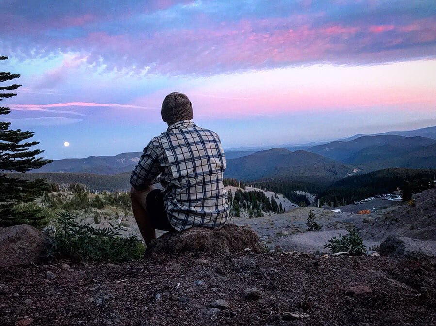
Photo by Chad Lubinksi
To sum it up, my advice to any aspiring long distance hiker is this: be willing to walk (literally!) outside your comfort zone, have little things to look forward to during the day, adopt a stoic philosophy, drop your ego, and LEARN from those on trail.
We are each far more capable than we think.
Although I’m not a thru-hiker, I encourage anyone that’s going to be pushing their comfort zone in the realm of hiking to take some of the things I learned from my hikes and put them in your tool belt. It could be the difference in whether you stay one more day to complete your trail hardiness break-in period… or walk out of the woods and back into your comfort zone, as I saw many times on my hikes.
I often wonder how everything would’ve transpired had I not met Salty Dog at Bobby Lake.
Photo by Chad Lubinksi
Want to keep up with all that’s going on at Atlas Guides? Sign up for our newsletter!
Read more!
Check out some related blog posts!
Get our trail guide for this area!
Pacific Crest Trail
The Pacific Crest Trail is an epic journey of three states and over 2600 miles. Its path travels from the US border with Mexico to the northern border with Canada.
2650 mi (4260 km) $29.99 full guide
Washington, Pacific Crest Trail
Photo by Justin Helmkamp
Washington, Pacific Crest Trail
Photo by Justin Helmkamp
Pacific Crest Trail
The Pacific Crest Trail is an epic journey of three states and over 2600 miles. Its path travels from the US border with Mexico to the northern border with Canada.
2650 mi (4260 km)
$29.99 full guide
Get our trail guide for this area!
About the Author
Natalie McMillan
Natalie grew up hiking in Arizona where she fell in love with the outdoors. Her favorite hikes are to Havasu Falls in the Grand Canyon and Angel’s Landing in Zion National Park, UT. She loves taking pictures of people, places, and nature, which might explain why she has almost 47,000 photos currently residing on her phone. She takes care of all things related to social media and marketing and recently moved to Denver, CO from Flagstaff, AZ. You may find her frolicking around the trails and mountains of Colorado, or exploring the new city she gets to call home.
IMPORTANT: Check-ins will only send to your followers when your phone is connected to WiFi or has cell service. Your phone cannot be in airplane mode to send a check-in.
Check-ins are stored on your phone until you are in cell phone reception/WiFi range and can not be used to contact Emergency Services.